Rev 210 http://www.ciclops.org/view/7959/Rev210?js=1 is in progress. Cloud monitoring images are now being done and one photo from Nov 26th is presented along with Celestia http://www.shatters.net/celestia/download.html grid and Solar System Simulation (SSS) http://space.jpl.nasa.gov/ images. These suffer from no details of the northern latitudes of Titan (above 50 degree N-latitude or so) and so the N polar seas such as Punga (P) are not shown. It could be I am not using the most recent versions of these otherwise great programs. The equatorial regions of Titan are well detailed however and one can use Celestia and SSS to identify the location of structures such as the Minerva (M) and Ksa (K) craters.
Click to view attachment
Full Version: Rev 210 Cloud monitoring and estuary glint (hopefully)
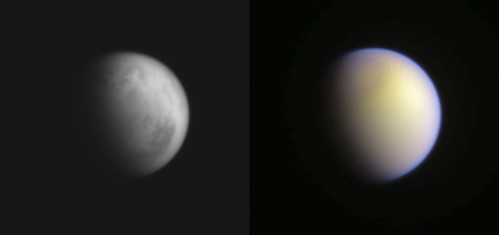
A couple of experimental 'golden' Titans, from the 26nd and 30th of November, using the CB3, MT1, and MT3 filtered images in both instances.
Click to view attachment
Click to view attachment
Click to view attachment
Click to view attachment
Two views of Titan on 30 November: stack cb3 on the left; red, grn, bl and uv on the right (unfortunately red was 512x512)
The T107 Titan flyby is less than 24 hrs away! Read the mission description here http://saturn.jpl.nasa.gov/mission/flybys/titan20141210/ .
A distant view of Titan on Dec4th shows sprawling Kraken in the north in the CL1 CB3 filtered image (initial part of the animation) and the colorful atmosphere in the RGB latter part of the image. Images courtesy Cassini Mission raw images http://saturn.jpl.nasa.gov/photos/raw/index.cfm
Welcome to the Titan blog Eli! Not sure how accurate it is but when it comes to the 512 red filtered images I usually change the image size to 1024 in photoshop elements so its the same size as the green and blue filtered images.
A golden globe award for your CB3 MT1 MT3 filtered images Ian!
Click to view attachment
Fantastic raw images from the Rev 210 T107 approach and flyby http://saturn.jpl.nasa.gov/photos/raw/inde...storedQ=2685855 are positioned on the ISS map http://www.ciclops.org//view_media.php?id=39721&js=1 below. Some interesting areas are identified with their official IAU http://planetarynames.wr.usgs.gov/SearchResults?target=TITAN names.
Click to view attachment
Click to view attachment
Question???
Some linear dark streaks appear in Titans upper atmospheric haze layers. What are these?Click to view attachment
1) Artifacts in the WAC camera or the CL1 VIO filter
2) Upper haze layer tracks made by Cassinis close encounter
3) Saturn ring shadows on Titans upper atmosphereClick to view attachment
4) Titan atmospheric changes now that the northern pole is warming up
5) Other things the experts will be telling me about?
How about cloud shadows? These should be long like this when we are near the terminator, analogous to "sun rays" or "crepuscular rays" we see on Earth. They look a bit off center though.
Swirls and contours at the edge of the north polar hood, I'd say. Localized differences in thickness of the high altitude haze will affect brightness in shorter wavelength filters as that haze is bluish. See this enhanced view of the north pole a year ago from another angle. If you look at this equatorial view from 2 yrs ago, it looks like shadowing is playing a major effect.
The northern polar hood is starting to get more and more structure at very short wavelengths
http://saturn.jpl.nasa.gov/photos/raw/rawi...?imageID=317581
http://saturn.jpl.nasa.gov/photos/raw/rawi...?imageID=318975
http://saturn.jpl.nasa.gov/photos/raw/rawi...?imageID=310663
http://saturn.jpl.nasa.gov/photos/raw/rawi...?imageID=317581
http://saturn.jpl.nasa.gov/photos/raw/rawi...?imageID=318975
http://saturn.jpl.nasa.gov/photos/raw/rawi...?imageID=310663
Thanks everyone! Hadnt noticed the CB3 image at 115K km (raw image W00090684) from which one can teased out some of the seas and hence ID the north pole. With that the bands become more obvious as part of the N polar hood in the RGB image, as discussed above.
Click to view attachment
Click to view attachment
Titan as imaged on Boxing Day 2014, using R,G,B, filters.
Slightly enhanced saturation to bring out more of the orange colour in the bottom of the image.
Click to view attachment
Slightly enhanced saturation to bring out more of the orange colour in the bottom of the image.
Click to view attachment
This is a "lo-fi" version of our main content. To view the full version with more information, formatting and images, please click here.