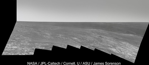
She's there! Opportunity drove down to the "Cook Haven" bright outcrops on Sol 3512.
Even better, news via Twitter that currents on the front right wheel are back to normal. Phew.
Full Version: Winter campaign at Cook Haven
It's been a while since we've seen DD/gusts at Endeavour - here's a new example from sol 3514:
http://qt.exploratorium.edu/mars/opportuni...0M1.JPG?sol++++
Compare with this frame if you're unconvinced:
http://qt.exploratorium.edu/mars/opportuni...0M1.JPG?sol++++
http://qt.exploratorium.edu/mars/opportuni...0M1.JPG?sol++++
Compare with this frame if you're unconvinced:
http://qt.exploratorium.edu/mars/opportuni...0M1.JPG?sol++++
Ooh, nice catch. I'm going to claim I missed that because I was looking at the ground.
Here's "Cape Douglas" on sol 3512, at Opportunity's current location. I'd guess that Cape Douglas might actually refer to the larger rocky area she's next to, but hard to say.
Here's "Cape Douglas" on sol 3512, at Opportunity's current location. I'd guess that Cape Douglas might actually refer to the larger rocky area she's next to, but hard to say.
Wow, now there's a rover on Mars as well. What a world we live in!
Phil
Phil
<checking calendar>
Uh, Phil, I thought rovers have been on Mars for a while...
Uh, Phil, I thought rovers have been on Mars for a while...
Sorry - all my attention has been diverted to the Moon for a few days!
Phil
Phil
QUOTE (jvandriel @ Dec 16 2013, 08:50 PM) 
The complete Navcam L0 view on Sol 3512-3514.
Jan, did you noticed the wide dust devil on the left? I do not recall any dust devil seen by Opportunity before, but probably my memory is failing...

Check post 286.
(Same dd image, I presume.)
(Same dd image, I presume.)
QUOTE (centsworth_II @ Dec 16 2013, 09:09 PM)
Check post 286.
(Same dd image, I presume.)
(Same dd image, I presume.)
Oops. I missed it! (and yes, my memory is definitely failing!)
Jan's panorama from just above in polar format. We are at the northern tip of a little outcrop that shows up clearly on the latest JPL route map.
Phil
Click to view attachment
Phil
Click to view attachment
The Dust Devil on Sol 3514.
( 1 image Sol 3514 and the other one Sol 3520 )
Jan van Driel
Click to view attachment
( 1 image Sol 3514 and the other one Sol 3520 )
Jan van Driel
Click to view attachment
Quick stitch of Sol 3527 Pan Cams with slight adjustments of contrast etc.
If I wasn't going out tonight I would do more on this interesting set of jpegs.
Click to view attachment
And thanks for the comments on the YouTube vid. Pitched at a different audience (although I went for as much accuracy as possible). But I hope they like it too. A great adventure.
If I wasn't going out tonight I would do more on this interesting set of jpegs.
Click to view attachment
And thanks for the comments on the YouTube vid. Pitched at a different audience
(although I went for as much accuracy as possible). But I hope they like it too. A great adventure.
QUOTE (jvandriel @ Dec 19 2013, 10:30 AM)
The Dust Devil on Sol 3514.
Here's a stretched difference of the (smoothed) 3514 and 3520 frames:
Click to view attachment
By matching features with an orbital view, I estimate the dd's distance as 2.9 km. That translates into a height of at least 230 metres. Since the dd extends to the top of the frame it is likely a fair bit taller than that. (You could estimate the full height from the length of the dark streak to its right, assuming that is its shadow.)
Oppy's up to 371 Whr now. Recently she was 100 Whr below this level, and 371 is pretty high for this time of year. I wouldn't be surprized if levels like this mean more driving flexibility.
The big panorama being created now includes the best view yet of Cape York from this area. Here is a composite of two frames:
Click to view attachment
and a 3x stretch to help interpret it. The distant horizon ridge would run up to the Santa Maria area.
Click to view attachment
Phil
Click to view attachment
and a 3x stretch to help interpret it. The distant horizon ridge would run up to the Santa Maria area.
Click to view attachment
Phil
Thanks for those, Phil. I can't wait to see this anniversary sequence in colour...
We haven't been to the distant ridge behind CY, but I see what you mean by it running to Santa Maria.
But we were in the direction of this frame, where we can also now see a distant ridge:
http://qt.exploratorium.edu/mars/opportuni...2M1.JPG?sol3539
This frame (more accurately the left side of the frame) is looking roughly towards where we made our big turn east after heading south from Victoria. I mentioned recently that our first sighting of Solander was around sol 2269 - that's also at the turn to the east. So we may now be seeing our route across the plains (though that depends how far away that distant ridge is).
My color version of Opportunity's Selfie of Sol 3538:
Click to view attachment
Click here for a larger version
Cheers, Udo
Click to view attachment
Click here for a larger version
Cheers, Udo
Here's the last MER Update by A.J.S. Rayl, containing a lot of goodies as usual.
I just would like to highlight a few details about the winter campaign and future plans after this season.
I just would like to highlight a few details about the winter campaign and future plans after this season.
QUOTE
Now that the rover is employing the lily pad strategy on Murray Ridge, "this winter for Opportunity will probably be like Spirit's first winter at Husband Hill," Stroupe said. That means, barring any unforeseen untoward event, the rover will continue to rove, lily pad to lily pad, and work throughout the harsh season.
QUOTE
The scientists have already spotted "a field geologist's dream," as Arvidson calls it, some 600 meters further south.
"It's a beautiful stratigraphic section of crust that's exposed on the western side of Endeavour's rim," said Arvidson. "You can walk up and down through time and along time following the outcrop."
"It's a beautiful stratigraphic section of crust that's exposed on the western side of Endeavour's rim," said Arvidson. "You can walk up and down through time and along time following the outcrop."
QUOTE (Phil Stooke @ Jan 7 2014, 07:28 AM)
The big panorama being created now includes the best view yet of Cape York from this area. Here is a composite of two frames:
Thanks Phil. That perspective really highlights the how and why of the illusion we were all ensnared by a couple years ago where Cape York seemed to be a vertical-rising peak from the overhead HIRISE images.
I wasn't going to post this and just wait until the color images came down, but here ya go. More to come. 
x-eyes of that amusing 'lil chunkster and stereo MI on SOL3541 reminds me of a rock I collected as a child in a volcanic steam vent in Hawaii.
Click to view attachment Click to view attachment
Click to view attachment Click to view attachment
Wondering where 'Pinnacle Island' came from? So was I; well, I still am. But it looks like it appeared between Sols 3536 and 3540. So in other words, it probably appeared during the turn on Sol 3540. Neat, huh?
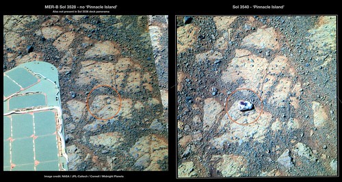
MERBSol3528-3540PinnacleIslandComparison on Flickr
MERBSol3528-3540PinnacleIslandComparison on Flickr
Fascinating little rock - totally different to the bedrock beneath
It looks different from the bedrock underneath, but is it? Looking at the bottom edge in particular, I could almost image it's a piece of bedrock that was broken off and flipped over.
Edit: Actually, I figured out what it reminds me of, a bit. Snake River. (Insert standard 'I'm not a geologist' disclaimer.)
Edit: Actually, I figured out what it reminds me of, a bit. Snake River. (Insert standard 'I'm not a geologist' disclaimer.)
Or "Tintina".
http://mars.nasa.gov/msl/multimedia/images/?ImageID=5145
But of coarse what we are seeing may or may not be similar materials.
http://mars.nasa.gov/msl/multimedia/images/?ImageID=5145
But of coarse what we are seeing may or may not be similar materials.
I think 'Tintina' was just the name for part of 'Snake River' that got broken off.
QUOTE (mhoward @ Jan 10 2014, 06:11 PM)
...it looks like it appeared between Sols 3536 and 3540...?
This rock must have popped out pretty far from under the rover's weight. A new record!
QUOTE (walfy @ Jan 11 2014, 07:41 PM)
This rock must have popped out pretty far from under the rover's weight. A new record!
Either that or it just fell out of the sky!


Then again, it does have kind of an iron-y, nickel-y look to it...
QUOTE (mhoward @ Jan 11 2014, 03:11 AM)
So in other words, it probably appeared during the turn on Sol 3540. Neat, huh?
Any chance it was trapped in the weel and released during the turn?Doesn't tell more about the rock but just wondering about this possibility.
I am guessing - just guessing - that our little friend might have come from here. (She drove over that spot on sol 3512.)
Color version:
Color version:
Here is the Mi cam panorama of that piece of rock from Sol 3541.
Jan van Driel
Click to view attachment
Jan van Driel
Click to view attachment
That's almost more confusing. An encrustation of gypsum, perhaps?
It really is a tiny piece and freshly separated (dust free). When Opportunity next moves it will be interesting to see the area obscured by the left front wheel where I would suspect it originated. A clast separated from the matrix rather than a fractured rock?
The pattern of the light-toned mineralization looks like it followed a set of cracks in the rock. Suggests aqueous intrusion to me.
What also catches my eye in this picture are the extremely fine lineations on some of the darker rounded rubble at the bottom of the image. Many of the tiny pebbles have very fine-grained scallops along the edges, others have hair-like, perfectly parallel grooves, some display aligned pits along their rounded surfaces. I'm guessing these are the remains of extremely thin strata, I guess I would find it harder to believe they're carved by eon-long persistent sand particle saltation.
-the other Doug
My immediate thought were that it might be a small piece of 'fool's gold' (FeS2 compound) but now nprev said gypsum I had a second look and indeed there's a small piece below that might have fallen off and it do look white.
I'm not sure, but it seems like a coal 
Probably gypsum although there are other possibilities. An APXS will narrow the field and we will no doubt get the good word in due course. Regardless the deposition implies a fracture which would explain this bit apparently breaking off so easily. There are a couple of displaced fragments of rock evident in mhowards image at post #318, located at the edge of the rock around 205 degrees from Pinnacle Island (taking the top of the image as north) which would seem to define the trajectory.
Good one, Paolo!!! (Long time no see, welcome back!)
(Long time no see, welcome back!)
Since there is no apparent trail leading to its current position, the rock must have flown through the air a fair distance. It seems difficult to explain how this could be triggered by the rover movement. Have we seen this kind of rover-induced rock mobility before?
It's on rock. It wouldn't leave a trail.
Phil
Phil
Ref my post #333, there are a few displaced 'pebbles' that, on rock, would seem to represent a trail.
Does that trail lead down-slope? I couldn't figure it out by a quick study of the images. If the rock is downhill from its origin, that would explain part of the distance it traveled maybe.
I never could find any trail of crumbs but the resting place is clearly downslope, apparently originating upslope on the crushed area as Moe pointed out. just how far that is, vertically as well, has proven difficult to pin down..
Click to view attachment
Click to view attachment
Interesting; I think there's more than a few pebbles disturbed. Here's a second attempt at a comparison, and you can see it looks like some bedrock has been disturbed (second circled area). (EDIT: Oops... actually not. On closer inspection, looks like it's just some dirt that got spread on the bedrock.)
Pinnacle Island is more or less northeast of the rover, so it's probably downslope.
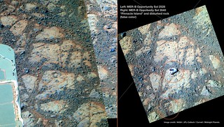
MERBSol3528-3540PinnacleIslandComparison2 on Flickr
Pinnacle Island is more or less northeast of the rover, so it's probably downslope.
MERBSol3528-3540PinnacleIslandComparison2 on Flickr
Oops... I guess I have to retract the previous post. On closer inspection, it just looks like some dirt got spread on the bedrock. Oh well! Mystery definitely not solved.
To me it just looks like the bedrock you're pointing to has had soil scattered onto it from the bottom direction on your image as PI skidded past.
Edit: you retracted before I finished posting!
I suppose that a loose piece of rock positioned just right as a wheel goes over it could be spat out at considerable speed, since the weight on the rock could be substantial. And that's even though the rover moves very slowly.
Edit: you retracted before I finished posting!
I suppose that a loose piece of rock positioned just right as a wheel goes over it could be spat out at considerable speed, since the weight on the rock could be substantial. And that's even though the rover moves very slowly.
This is a "lo-fi" version of our main content. To view the full version with more information, formatting and images, please click here.