I've downloaded most of the rdrs now so I thought I'd have a play with the data.
This is an image of the South Pole, The area shown is about 200kmx200km. I haven't tried to be accurate with the vertical scale.
Here's a contour map of the same area, the contour interval is 200m.
Full Version: South Pole image from LOLA data
I'm getting severe orbit streaking when I create high resolution(~5m) gridded datasets from the RDRs. Has anyone noticed orbit streaks in the 5m resolution GDRs?
Heres a shaded relief map of the south pole, centered on 89.8S 270E. The area shown is 100kmx100km. The heighest point is 2078m the lowest is -2999 m. Orbit streaks are visible but not too bad in this image because it is using a lower resolution dataset (80m).
Heres a shaded relief map of the south pole, centered on 89.8S 270E. The area shown is 100kmx100km. The heighest point is 2078m the lowest is -2999 m. Orbit streaks are visible but not too bad in this image because it is using a lower resolution dataset (80m).
It will take time to remove all the streaks, which are caused by track-to-track errors in the orbit determination. They can be removed by comparing tracks that cross each other, but that will wait until later in the mission or after it. These are, after all, only interim products. (Incidentally, the low resolution Magellan altimetry at PDS is realy bad for that. A cleaned-up version was created at some point but does not seem to have been archived)
Phil
Phil
My anti-virus doesn't like that mars3d site for some reason 
QUOTE (Hungry4info @ Jan 2 2011, 01:35 PM) 
My anti-virus doesn't like that mars3d site for some reason
Ditto
Does it give any indication what the virus is?
I just went there, no alarms from NAV Pro.
Firefox/Mozilla is giving me an Attack Site warning.
------- TEXT --------
Reported Attack Page!
This web page at www.mars3d.com has been reported as an attack page and has been blocked based on your security preferences.
Attack pages try to install programs that steal private information, use your computer to attack others, or damage your system.
Some attack pages intentionally distribute harmful software, but many are compromised without the knowledge or permission of their owners.
-----------TXT ---------------
url http://google.com/safebrowsing/diagnostic?.../www.mars3d.com
Google
Safe Browsing
Advisory provided by Google
Diagnostic page for www.mars3d.com
What is the current listing status for www.mars3d.com?
Site is listed as suspicious - visiting this web site may harm your computer.
Part of this site was listed for suspicious activity 1 time(s) over the past 90 days.
What happened when Google visited this site?
Of the 20 pages we tested on the site over the past 90 days, 3 page(s) resulted in malicious software being downloaded and installed without user consent. The last time Google visited this site was on 2010-12-21, and the last time suspicious content was found on this site was on 2010-12-21.
Malicious software is hosted on 1 domain(s), including nt02.co.in/.
This site was hosted on 1 network(s) including AS4323 (TWTC).
Has this site acted as an intermediary resulting in further distribution of malware?
Over the past 90 days, www.mars3d.com did not appear to function as an intermediary for the infection of any sites.
Has this site hosted malware?
No, this site has not hosted malicious software over the past 90 days.
How did this happen?
In some cases, third parties can add malicious code to legitimate sites, which would cause us to show the warning message.
------------------------------------------
Maybe a redirect?
------- TEXT --------
Reported Attack Page!
This web page at www.mars3d.com has been reported as an attack page and has been blocked based on your security preferences.
Attack pages try to install programs that steal private information, use your computer to attack others, or damage your system.
Some attack pages intentionally distribute harmful software, but many are compromised without the knowledge or permission of their owners.
-----------TXT ---------------
url http://google.com/safebrowsing/diagnostic?.../www.mars3d.com
Safe Browsing
Advisory provided by Google
Diagnostic page for www.mars3d.com
What is the current listing status for www.mars3d.com?
Site is listed as suspicious - visiting this web site may harm your computer.
Part of this site was listed for suspicious activity 1 time(s) over the past 90 days.
What happened when Google visited this site?
Of the 20 pages we tested on the site over the past 90 days, 3 page(s) resulted in malicious software being downloaded and installed without user consent. The last time Google visited this site was on 2010-12-21, and the last time suspicious content was found on this site was on 2010-12-21.
Malicious software is hosted on 1 domain(s), including nt02.co.in/.
This site was hosted on 1 network(s) including AS4323 (TWTC).
Has this site acted as an intermediary resulting in further distribution of malware?
Over the past 90 days, www.mars3d.com did not appear to function as an intermediary for the infection of any sites.
Has this site hosted malware?
No, this site has not hosted malicious software over the past 90 days.
How did this happen?
In some cases, third parties can add malicious code to legitimate sites, which would cause us to show the warning message.
------------------------------------------
Maybe a redirect?
I also get a Firefox "Attack Page" warning. This is on Firefox 4.0 Beta 8.
Thanks for all the info guys, particularly stewjack.
I have now cleaned the infected pages, firefox and google may continue to show warnings until google does another check on the site. That could take days/weeks.
I have now cleaned the infected pages, firefox and google may continue to show warnings until google does another check on the site. That could take days/weeks.
FYI, on IE8, no prob. Using Firefox 3.6 (yes, I know) just now got the warning.
QUOTE (nprev @ Jan 3 2011, 01:18 AM)
FYI, on IE8, no prob. Using Firefox 3.6 (yes, I know) just now got the warning.
Thanks, I think firefox checks against google's list of sites with malware. So I am expecting it to continue to give warnings until google updates its list.
You can request a review through Google Webmaster Tools:
http://www.google.com/support/webmasters/b...py?answer=45432
http://www.google.com/support/webmasters/b...py?answer=45432
QUOTE (Fran Ontanaya @ Jan 3 2011, 01:30 AM)
You can request a review through Google Webmaster Tools:
http://www.google.com/support/webmasters/b...py?answer=45432
http://www.google.com/support/webmasters/b...py?answer=45432
Thanks, I've done that and google is now showing the site as clean.
I can produce 3d relief maps pretty easily now so if anyone would like to request a map of an interesting area then please do. Bear in mind that the best quality results will be from areas near the poles.
QUOTE (Mars3D @ Jan 2 2011, 04:40 PM)
I have now cleaned the infected pages,
Be sure and change your passwords and also look for nefarious user accounts on your site.
QUOTE
I'm getting severe orbit streaking when I create high resolution(~5m) gridded datasets from the RDRs. Has anyone noticed orbit streaks in the 5m resolution GDRs?
The heighest point is 2078m the lowest is -2999 m. Orbit streaks are visible but not too bad in this image because it is using a lower resolution dataset (80m).
The heighest point is 2078m the lowest is -2999 m. Orbit streaks are visible but not too bad in this image because it is using a lower resolution dataset (80m).
the poles "should" be much better than the mid latitude +45 to -45
Now there is the scientific removal but that will be in a few years .When there is much more data , that can be averaged better.
There is also an"Artistic " smoothing without bluing that i used for the 256 px./ deg. full map I made .
that involved using a heat flow pde that " G'mic" ( grastoration / Cimg.h ) uses .
an example

now that is NOT near the pole and thus needs a very BIG correction
just took a look at the south pole 10 m rdr IMG ,that is a bit striped
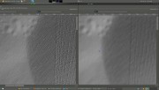
for the images below
1) the image on the left is a crop and ONLY had a "emboss" applied to it for viewing the 16 bit image
2) for the one on the right , the same plus some "destripping " in Gmic
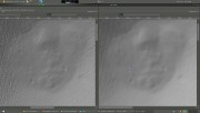
for the images below
1) the image on the left is a crop and ONLY had a "emboss" applied to it for viewing the 16 bit image
2) for the one on the right , the same plus some "destripping " in Gmic
Current orbits are good to 15-20m, so I am not surprised that the orbit errors show up at 5m resolution. We're working on it (for example, by developping new gravity field models), but 5m is currently not achievable. (For reference, the original requirement was 50m). Maybe after GRAIL gives us a perfect gravity field!
Also, keep in mind that each laser footprint is ~5m in diameter, so your maps will have very sparse coverage at those resolutions.
Also, keep in mind that each laser footprint is ~5m in diameter, so your maps will have very sparse coverage at those resolutions.
This is a "lo-fi" version of our main content. To view the full version with more information, formatting and images, please click here.