Help - Search - Members - Calendar
Full Version: Go For Vostok
Unmanned Spaceflight.com > Mars & Missions > Past and Future > MER > Opportunity
Pages: 1, 2, 3
dot.dk
Done with the heatshield and on the road to Vostok wink.gif


Time to put the pedal to the metal! How far is the maximum drive distance in one SOL? Will Oppy be able to make a new one day drive record despite the dust in the sky?
djellison
Unlikely to break that 140m record - but 100m is doable, easily.

They may want to hop from feature to feature though - there's a lot of them out here

Impossible to tell how far they've gone from the Heatshield though. There's end of drive L7/R1 direction of drive mosaics - and lots of navcam, but not quite enough navcam to show us where the heatshield is yet smile.gif

I think they turned in place at the end of the drive - something thye often do to optimize the UHF pases ( i.e. limit line of sight blockage by PMA, HGA, LGA etc )

Doug
dot.dk
Yeah I too wanna know how far away they are from the heatshield biggrin.gif

But now Oppy has a chance to steal the total drive distance record from Spirit. Looks like Oppy is stealing all the limelite from Spirit laugh.gif
Poor Spirit sad.gif
mook
Oppy might be stealing the limelight from Spirit, but Spirit's gonna have the best views in the house for some time yet....
dot.dk
QUOTE (dot.dk @ Jan 26 2005, 09:19 AM)
Oppy might be stealing the limelight from Spirit, but Spirit's gonna have the best views in the house for some time yet....

Until Oppy reaches Victoria Crater wink.gif

Man, that thing gotta be HUGE ohmy.gif
Bert
Hi all,

Guest/lurker of the first hour here, finally breaking the spell! tongue.gif

I was looking at the "Route to Victoria" image ( http://mer.rlproject.com/index.php?showtopic=349 ) and I wondered where exactly Vostok Crater is in that image.

Does anyone know?
Bert
Nevermind.

I found the answer here:

http://marsrovers.jpl.nasa.gov/gallery/pre...h-A357R1_br.jpg
mars_armer
Not sure if anyone has already posted this, but here's the initial driving plan from the heatshield to Vostok:

dot.dk
Wow great map biggrin.gif

But I really doubt those small craters are gonna show anything. They will only be small depressions on the plains. But then we will get to Vostok quicker smile.gif
djellison
Those little craters are just like Fram I'd imagine...

Vostok looks like it'll be a very interesting place though - almost like a stone age banjo enclosure smile.gif

Oh - PS - where in hells name did you get that picture smile.gif Is this another Pando situation? (From a happy-to-help insider, I could tell you, but I'd have to shoot you)

Wherever it came from thank you biggrin.gif

PPS - for those confused, north is left on that image.

Doug
mars_armer
QUOTE (djellison @ Jan 26 2005, 03:54 PM)
Oh - PS - where in hells name did you get that picture smile.gif  Is this another Pando situation? (From a happy-to-help insider, I could tell you, but I'd have to shoot you)

Wherever it came from thank you biggrin.gif

I'm not sure what Pando's situation is, but your guess is pretty good about mine. I have a couple of happy-to-help insiders. I don't know if they are breaking any rules in forwarding information, so I want to be careful about posting.

I debated whether to post the picture, but it seemed so informative I decided to take a chance. I imagine JPL will soon be releasing something similar, since there won't be much else for them to talk about during this driving phase.
tedstryk
Good to see Oppy getting moving. I mean, remember, even Spirit's longer treck is only 2.5 miles....comparable to the outbound leg of a short dayhike. While the distance it has travelled has been remarkable, I think of how much of the nearby Great Smoky Mountains I could explore in a 2.5 mile hike (Granted, that would be limited by tree cover during portions of the year making it worse here on earth). I wonder how far Oppy will go....
paulanderson
In the same TPS interview where he talks about Peace rock, Squyres also mentions Vostok in the last paragraph:

http://planetary.org/news/2005/mer-update_0121.html

"In coming sols, Opportunity will continue her journey southward along the Meridiani plains, to an area called Etched Terrain, "hop-scotching from crater to crater," as Squyres put it. The next target is Vostok -- a circular feature that is crater-like in appearance but is unusual. But from now one, she'll be giving those cobbles a second look."

I had also just heard him in a radio interview (Planetary Radio from TPS, January 3) where he said he had doubts that Vostok is actually a crater (or not a typical one at least) and he was quite interested in getting to it.

Paul
djellison
There's a new Director Update ( Jeff Favretto - he does cool ones biggrin.gif )

He mentioned that Opportunity was instructed to drive 80 metres today and it is hoped it will do ONE HUNDRED AND SIXTY METERS tomorrow

let me say that again

ONE HUNDRED AND SIXTY METERS.

If they do it - it's a new mars distance record smile.gif - and it'll put the heatshield as just a few pixels on Navcam and bring us to that first crater on the crater-hop image - which looks mainly like a bit of a Fram - but seing as it follows a new record and we're likely to set quite a few over the next few months - I think we should give them names of land speed record holders smile.gif

So - Next stope - Green Crater ( followed by Noble, Gabelich, Breedlove, Arfons....)

Doug
Sunspot
QUOTE (djellison @ Jan 27 2005, 12:27 AM)
There's a new Director Update ( Jeff Favretto - he does cool ones biggrin.gif )

He mentioned that Opportunity was instructed to drive 80 metres today and it is hoped it will do ONE HUNDRED AND SIXTY METERS tomorrow

let me say that again

ONE HUNDRED AND SIXTY METERS.

If they do it - it's a new mars distance record smile.gif - and it'll put the heatshield as just a few pixels on Navcam and bring us to that first crater on the crater-hop image - which looks mainly like a bit of a Fram - but seing as it follows a new record and we're likely to set quite a few over the next few months - I think we should give them names of land speed record holders smile.gif

So - Next stope - Green Crater ( followed by Noble, Gabelich, Breedlove, Arfons....)

Doug

An excellent idea on crater names. It's just past 1pm at Meridiani - so I presume Opportunity has hit the road by now biggrin.gif

edit: A note of clarifiaction, the 80 metre drive was JUST completed and seen in the most recent navcam images etc? And the 160 is currently underway?
djellison
QUOTE (Sunspot @ Jan 27 2005, 12:51 AM)
edit: A note of clarifiaction, the 80 metre drive was JUST completed and seen in the most recent navcam images etc? And the 160 is currently underway?

That's how I read it - he said the long drive would be tomorrow (i.e. 27th ) - which is, well, today GMT biggrin.gif


Doug
djellison
Well - the parallax calculator puts the 'big piece' as 81.6m +/-15 and a size of 2.6m which sounds about right


Doug
Sunspot
.....so they didnt drive this most recent sol then?

I hope his "160m drive" statement isn't another "we'll be leaving the crater in a week" lol
djellison
QUOTE (Sunspot @ Jan 27 2005, 10:32 AM)
"we'll be leaving the crater in a week" lol

six months later.... wink.gif

Not sure when they've driven and when they've not. I THINK, looking at navcam - they drove did the 80m drive straight after the final MI sequence on the heatshield - then perhaps because of a restricted sol or something - didnt drive, and then tonight it'll do the big drive

Notice the quite long delay between frames on this end of 80m drive sequence..

http://qt.exploratorium.edu/mars/opportuni...cam/2005-01-25/
I was going to suggest that the long 3 minute gap between frames might be a symptom of multi-spectral imaging, but no - looking back - it's normal for the end of sol L7/R1 3x1 mosaic


Doug
dot.dk
Looks like old Oppy still have some juice left biggrin.gif

At 160m/day we could move over 1 km a week. Victoria here we come tongue.gif
Too bad it will be far from the average speed sad.gif
Sunspot
At what point suring the drive south will the etched terrain start to become visible? Also the rasied rim of Endurance is qutie prominent from this location - I wonder if Victoria Crater will be visible on the distant horizon in a similar manner. - but from a much greater distance
djellison
Etched terrain starts about, erm well. - from the heatshield...

'Green' Crater - 220 m
Vostok Crater - 1100 m
Very closest obvious etched terrain - 2200m SW
Subtle Etched Terrain - 2600m S
Large 'crater like' etched terrain feature - 3500m SSW
'End' of etched terrain before Victoria Crater - 5400m S
NW rim of Victoria Crater - 5600m S
S rim of Victoria Crater - 6400mS

Distance from Eagle to Endurance. - 700m smile.gif


Other stats....
Diameter of Victoria Crater EW - 715m
Diameter of Victoria Crater NS - 770m
Diameter of Victoria Crater central dune field - 270-300m
Width of Victoria Crater NW 'entrance ramp' - 30m
Width of Victoria Crater W 'entrance ramp' - 60m
Diameter of crater-like feature in etched terrain 320m
As the Crow Flies - Eagle to Victoria - 6600m
Diameter of Eagle Crater - 25m
Diameter of End Crater - 170m
Diameter of End Crater Dune Field - 40m
Diameter of Vostok Crater - 30-50m

Sizes
Scaling factor - Eagle to Vostok Crater - 160%
Scaling factor - Eagle to Endurance crater - 680%
Scaling factor - Eagle to Victoria - 2920%
Scaling Factor - Endurance to Victoria - 430%

Angles
715m crater width in pixels
Range : Pancam : Navcam
6000 : 425 : 156
3000 : 856 : 315
1500 : 1770 : 650

Technically - Victoria should be fairly obvious at this range - however - Mars is quite a bit smaller than earth - distance to Horizon = 83.38 X height^.5

Pancam height is 1.54m - thus horizon is about 3.27km away - so we will not see Victoria for some time to come with MER.

With Hazcam, the horizon is approx 1.9km away

Bottom line - we'll need to travel about as far south from Vostok as Vostok is south from Endurance before we see Victoria - unless it's really really tall smile.gif
Height (m) Visible from (km) Pixel Width of 720mCrater
0 | 3.27 | 784
1 | 4.27 | 599
2 | 5.27 | 484
3 | 6.27 | 407
4 | 7.27 | 351
5 | 8.27 | 308
6 | 9.27 | 275
7 | 10.27 | 248
8 | 11.27 | 226
9 | 12.27 | 207
10 | 13.27 | 192
12 | 15.27 | 167
14 | 17.27 | 147
16 | 19.27 | 132
18 | 21.27 | 120
20 | 23.27 | 109
22 | 25.27 | 101
24 | 27.27 | 93
26 | 29.27 | 87
28 | 31.27 | 81
30 | 33.27 | 76
35 | 38.27 | 66
40 | 43.27 | 59
45 | 48.27 | 53
50 | 53.27 | 48
60 | 63.27 | 40
70 | 73.27 | 35
80 | 83.27 | 31
90 | 93.27 | 27
100 | 103.27 | 25


Doug
babakm
I also wonder if there is a slight downhill from the blueberry fields to the etched terrain. Some of the sat imagery suggests that. Has anyone seen topo/3d maps of the area?
Sunspot
Some facinating number there Doug, thanks for that.

These two pancam images from sol 315 are looking south past the heatshield, no obvious features visible sticking up above the distant horizon. Although, there is a dark linear feature visble in the second image a couple of pixels thick.

http://marsrovers.jpl.nasa.gov/gallery/all...0P2351L7M1.HTML

http://marsrovers.jpl.nasa.gov/gallery/all...0P2351L7M1.HTML
tedstryk
I imagine when we see Victoria will be determined by obstructions and how high its rim rises above the plain. If the etched terrain doesn't get in the way, we may see it sooner than calculated if any of the rim is raised enough.
djellison
QUOTE (tedstryk @ Jan 27 2005, 04:46 PM)
I imagine when we see Victoria will be determined by obstructions and how high its rim rises above the plain. If the etched terrain doesn't get in the way, we may see it sooner than calculated if any of the rim is raised enough.

That was the point in doing the maths to calculate at what range the rover would first see something of 1, 5, 10, 20 metres high appear over the horizon.

Victoria is big. Very big. Now - if it's say 1/20th as tall as it is wide - thats 35 metres

Lets say we need half of that to appear over the horizon before we 'see' the crater

So - 16 metres should be visible form a range of 19km, the crater would be 132 pixels wide, and that 16 metres perhaps only 3 pixels tall.

Tip - use L2 filters to look for it - they bring out rock outcrops as very very very bright -

( http://marsrovers.jpl.nasa.gov/gallery/all...30P2213L2M1.JPG of endurance for instance )

Now - to be honest - I'm astonished we've not seen it yet - especially from the heigh advantage given to us at Pan Position 2 ( sols 122ish )

Doug
Sunspot
There is a little bump on the horizon in this image from sol 121, I think we are looking south.

http://marsrovers.jpl.nasa.gov/gallery/all...9P2263L6M1.HTML

A few more on the right side of this image, although I suspect were looking in a different direction to Victoria.

http://marsrovers.jpl.nasa.gov/gallery/all...9P2263L6M1.HTML
djellison
Yup - I'm looking at PDS stuff form Sol 121 and 122 - will report back as and when i have any luck finding something. With L2 it SHOULD be very clear - but it isnt

Doug
djellison


I'm fairly sure that's Victoria - it's just about the right size w.r.t pixels. It may be that it doesnt have particularly high crater walls - at this distance it doesnt look like it has any at all - but it is 6k away biggrin.gif

Doug
Sunspot
Great picture there smile.gif

Take a look at the latest pancam shots

http://qt.exploratorium.edu/mars/opportuni...FWP2359R1M1.JPG

It's going to be difficult to get our bearings out on the plains, but i'm assuming it's a view south in the drive direction - there is definately someting on the horizon.
Bill Harris
Do we have access to data that shows the azimuth fo each image? I'm sure that NASA can calculate that from the engineering data, but it would be nice to have that for our guesstimates.

But the closer we get the more prominent Victoria will appear.

--Bill
djellison
There is azimuth data in the header for each -img file in the pds but not for the jpg releases.
arccos
What is the object no. 4 in mars_armer's picture?
djellison
QUOTE (arccos @ Jan 28 2005, 08:41 AM)
What is the object no. 4 in mars_armer's picture?

It's. umm...

a mars thing

tongue.gif

Doug wheel.gif wheel.gif wheel.gif
dot.dk
Looks like Oppy has performed the mega drive, but once again we can't see where we are tongue.gif
Fred
I think these bumps on the horizon could be the etched terrain that exends north to the west of Victoria. This picture was taken to the right of that horizontal line in Doug's picture that might be Victoria.

Sunspot
QUOTE (mars_armer @ Jan 26 2005, 03:34 PM)
Not sure if anyone has already posted this, but here's the initial driving plan from the heatshield to Vostok:


I wonder if the very dark patch that looks a little like the heatshield impact site might be a recent meteorite impact?
Sunspot
JPL have posted a new text update on the rover site, the first drive covered 86.3m, and they are heading for a crater called "Argo" Could the dark patch in the top left of this image be Argo?

http://qt.exploratorium.edu/mars/opportuni...00P2360R1M1.JPG
djellison
Argo is the JPL name for Green Crater smile.gif

Doug
Pando
That looks like a nice drive smile.gif

dot.dk
That's the 80 meter drive isn't it?
djellison
yup

Doug
djellison
http://www.jpl.nasa.gov/missions/mer/fligh...28-Jones-T1.mov

They got 154 metres on the long drive, and are planning a similar length drive today

ohmy.gif

300m in 2 days biggrin.gif

Obviously a LOT of crater hoping and stop-offs en route - but at that rate, they could actually cover the ground to Victoria in, hell - 8 working weeks tongue.gif

That deserves wheel.gif wheel.gif wheel.gif

Doug
ilbasso
To avoid the overworked wheel that we had on Spirit, will they be alternating forward and backward drives? Or does traversing the easier terrain in itself less stressful on the drive mechanism?
Sunspot
QUOTE (djellison @ Jan 29 2005, 02:15 AM)
http://www.jpl.nasa.gov/missions/mer/fligh...28-Jones-T1.mov

They got  154 metres on the long drive, and are planning a similar length drive today

ohmy.gif

300m in 2 days biggrin.gif

Obviously a LOT of crater hoping and stop-offs en route - but at that rate, they could actually cover the ground to Victoria in, hell - 8 working weeks tongue.gif

That deserves  wheel.gif  wheel.gif  wheel.gif

Doug

A weekend drive? The flight directors report mentions back to back driving.. but from looking at the hazcam image, they dont seem to have performed the drive mentioned in the report.

The navcam shots show they;re pretty close to the crater now, looks like a small version of Eagle.

http://qt.exploratorium.edu/mars/opportuni...00P1617L0M1.JPG


Navcam image of the drive :

http://qt.exploratorium.edu/mars/opportuni...00P1617R0M1.JPG
dot.dk
Back to back driving means they will just zoom past this small crater?

On another note it is great to see more frequent flight director reports biggrin.gif
djellison
QUOTE (dot.dk @ Jan 29 2005, 01:03 PM)
Back to back driving means they will just zoom past this small crater?

On another note it is great to see more frequent flight director reports biggrin.gif

Umm - actually -yeah, I think so. 150+150+80 - 380 metres - further than that crater I believe

Doug
Sunspot
These two navcam frames show they have passed the crater....
TheChemist
Too lazy to work on a Saturday rolleyes.gif
Here is an (amateurish, be gentle smile.gif
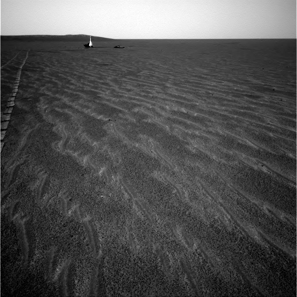
) panoramic view from NavCam images.
dot.dk
That's a great panorama wink.gif
This is a "lo-fi" version of our main content. To view the full version with more information, formatting and images, please click here.
Invision Power Board © 2001-2024 Invision Power Services, Inc.