Finally, Spirit's making some progress towards Larry's Leap. It'll be refreshing to see different topography for a change.
One item I'm curious about and I've seen only a few messages here on it. What is the general concensus here about the feature called the "Ultreya Abyss"? The orbital images don't show much: there _is_ a low albedo feature there but I can't say that it is a opening. Early in the mission, I recall that Spirit was to go to Ultreya after contacting the West Spur but those plans changed by the time she got to Columbia Hills. I imagine that the planners wanted something different than the basaltic plain and wanted to examine layered exposures.
--Bill
Full Version: Ultreya Abyss
If they eventually will reach the Summit of Husband Hill we may have a look at it 
The so-called 'Abyss' has created some stir among fans in markcarey.com blog, but I don't think NASA is too excited about it or they would be on their way there already. It seems to be simply a darker-colored sand collected downwind which is in the shadow of the mountain. If you do some comparisons from orbital images of Bonneville crater vs. the 'Ultreya', there isn't anything exciting there. The appearances are very similar and we all know now what Bonneville looks like (sorry ustrax)...
Yes, I have to agree. Ustrax's images (particularly the ones detailing the proposed aquifiers for the abyss) are rather fanciful. As for why NASA changed their minds regarding their proposed route, IIRC it was because of the drop-off in power that Spirit was receiving required them to be on a north-facing slope, preferably with an uptilt. The current path satisfies both requirements to maximise the lower solar energy of the Martian winter.
I suppose it's possible that the dark area is indeed an 'abyss' of some kind or another.. but I think it's unlikely. That said, I do think we'll find out eventually, probably from Spirit. Why would dark sand collect all in one place, anyway? Heck if I know..
QUOTE (Bill Harris @ Jan 7 2005, 04:55 PM)
Early in the mission, I recall that Spirit was to go to Ultreya after contacting the West Spur but those plans changed by the time she got to Columbia Hills. I imagine that the planners wanted something different than the basaltic plain and wanted to examine layered exposures.
I'm coming in late, but I'm glad you brought that up. I've wondered about it for a long time. I don't recall that they said they were particularly interested in the low albedo area, although that interested me.
I thought the original plan was to head around to the southeast of West Spur, and climb Lookout Rock to see if there were layered deposits thought to be in the vicinity.
I think Spirit might have a look at it from above Husband Hill if the slopes permit but I'm equally interested in the crater right in front of Spirit, I think it'd be a 200-meter drive and the floor looks quite interesting although the terrain looks a bit rough..
Thanks for the feedback. I've wondered about Ultreya for some time but wanted to get "another perspective" on it. From the MOC images the area does look compelling, but too much of a gamble to have gone to directly. Evidently, what they found on the Gusev plain was different that what was originally suspected and the Columbia Hills were more appealing. I think thay the expected to see more evidence of an ancient lakebed but found a basalt plain.
It would be a shocker if they found a big black Monolith in Ultreya once Spirit was able to look into it...
--Bill
It would be a shocker if they found a big black Monolith in Ultreya once Spirit was able to look into it...
--Bill
I think the stay in the bottom of endurance crater helped opportunity. The
lower areas seem to be warmer and have higher air pressure. We saw frost
and that may have been what cleaned opp's solar panels.
Spirit could use a therapeutic stay at the bottom of the abyss - get the
panels cleaned off and warm up a bit. If indeed the abyss is deep then Spirit
may get a chance to steal the limelight back from Opportunity for a bit.
I had the original, planned route map from last May, but for some reason I was not able to upload it with my last post. So, I found the link to the press release image. The caption there describes why they were interested in the so-called inner basin. I assume the low-albedo area east of Lookout Point in this image is the Ultrea Abyss you are talking about.
http://marsrovers.jpl.nasa.gov/gallery/pre.../20040521a.html
Now, it looks as if we'll get an even better overview of the area from Larry's Leap.
http://marsrovers.jpl.nasa.gov/gallery/pre.../20040521a.html
Now, it looks as if we'll get an even better overview of the area from Larry's Leap.
Yes, that is the earlier route that I mentioned. Larry's Lookout looks eastward and Husband Hill will be between the lookout and the Inner Basin. If Spirit goes to the top of Husband Hill and/or south of this hill she might be able to look into the Inner Basin.
Of course this is one of a gazillion enigmas on Mars, we'll get around to it eventually...
--Bill
Of course this is one of a gazillion enigmas on Mars, we'll get around to it eventually...
--Bill
I really don't think it's an enigma. The low-albedo area is interesting, but most likely just an area of dark soil. The Inner Basin they speak of is the entire low area E and SE of Lookout Point, including Home Plate and some of the potentially layered rocks.
I've been eager to see this area for a lot of reasons, but I don't expect we'll see a cave or deep hole in the dark area.
I think we'll see some intriguing outcrops that will entice Spirit down into the basin.
I've been eager to see this area for a lot of reasons, but I don't expect we'll see a cave or deep hole in the dark area.
I think we'll see some intriguing outcrops that will entice Spirit down into the basin.
Of course - that area is S / SE facing, and so will have to wait till summer before being visited. To venture there now would, I imagine, kill Spirit very quickly indeed - a matter of a few sols.
Doug
Doug
I'm curious why everyone believes that basin contains darker soil. My first impressions looking at the pictures was that the area was simply in shadow when photgraphed from the orbiter. I would assume that any subsequent imaging was attempted when lighting conditions were much the same.
I've seen a number of orbital pictures from Mars that were 3D anaglyphs. Why haven't we seen any from the two landing areas in 3D? Obviously they have the offset shots to be able to have created the perspective views. What I'd truly love is for ESA to image one or both of the landing spots. Has its orbit simply not taken it over those areas yet?
I've seen a number of orbital pictures from Mars that were 3D anaglyphs. Why haven't we seen any from the two landing areas in 3D? Obviously they have the offset shots to be able to have created the perspective views. What I'd truly love is for ESA to image one or both of the landing spots. Has its orbit simply not taken it over those areas yet?
Don't know about the dark soil, we'll have to see. There are more dark patches in the crater 'on top' of Columbia Hills.
It would be great if Mars Express turned its cameras at the Mer landing sites but there has been a Nasa anaglyph of Spirit's location. Don't know for sure for Opportunity.
MSSS
It would be great if Mars Express turned its cameras at the Mer landing sites but there has been a Nasa anaglyph of Spirit's location. Don't know for sure for Opportunity.
MSSS
QUOTE (azstrummer @ Jan 9 2005, 11:42 AM)
I'm curious why everyone believes that basin contains darker soil. My first impressions looking at the pictures was that the area was simply in shadow when photgraphed from the orbiter. I would assume that any subsequent imaging was attempted when lighting conditions were much the same.
I've seen a number of orbital pictures from Mars that were 3D anaglyphs. Why haven't we seen any from the two landing areas in 3D? Obviously they have the offset shots to be able to have created the perspective views. What I'd truly love is for ESA to image one or both of the landing spots. Has its orbit simply not taken it over those areas yet?
I've seen a number of orbital pictures from Mars that were 3D anaglyphs. Why haven't we seen any from the two landing areas in 3D? Obviously they have the offset shots to be able to have created the perspective views. What I'd truly love is for ESA to image one or both of the landing spots. Has its orbit simply not taken it over those areas yet?
Regarding the dark soil, I'm simply making an educated guess, agreeing with Pando's comment above, and also noting that many of the craters on Mars are floored with a darker soil. This area and the ones to the north mentioned by Nix are noticeable depressions that conceiveably could be dark for the same reason as the craters. I'm sure that shadowing is partly to blame, but I don't think it is the sole cause of the darkness.
When I was reading about this 'Ultreya' region I did come across a site that had an anaglyph and a stereo pair of this area. There is also a link to that markcarey discussion where someone posts links to the original images at the MSSS site.
http://www.marsgeo.com/Spirit/Ultreya.htm
The anaglyph is not that great and I'd really like to see one for the whole of Columbia Hills, but I haven't gotten around to learning how to make them, yet.
If I'm not mistaken, Spirit is nowhere close to Ultreya Abyss. The map/route that was posted earlier in this thread was from prior to Spirit reaching the Columbia Hills. The lookout point it's referring to is not the same lookout point that Spirit is headed to. The first image below is the older map, the next image is the more recent map...


So right now, talk of investigating the "Ultreya Abyss" is premature to say the least.
Eric P / MizarKey
So right now, talk of investigating the "Ultreya Abyss" is premature to say the least.
Eric P / MizarKey
I don't think anyone's talking about it in the sense that Spirit's going to be exploring it any time soon. The only reason anyone got excited, was because someone over on markcarey.com saw the original intended route of Spirit passed by a region of low albedo, and interpreted the dark patch as being a fantastical system of caves. Images of Spirit spelunking through the Martian substrata only served to fire the flames of imagination of the other forum participants...
Now, personally, I'm more interested in getting to the top of Husband Hill, and having Spirit snap the panorama to end all panoramas. It will not only answer the question of Ultreya, but will also be a view that won't be bettered on Mars until at least 2007.
Now, personally, I'm more interested in getting to the top of Husband Hill, and having Spirit snap the panorama to end all panoramas. It will not only answer the question of Ultreya, but will also be a view that won't be bettered on Mars until at least 2007.
QUOTE (mook @ Jan 9 2005, 08:57 PM)
I don't think anyone's talking about it in the sense that Spirit's going to be exploring it any time soon...
Now, personally, I'm more interested in getting to the top of Husband Hill, and having Spirit snap the panorama to end all panoramas. It will not only answer the question of Ultreya, but will also be a view that won't be bettered on Mars until at least 2007.
Now, personally, I'm more interested in getting to the top of Husband Hill, and having Spirit snap the panorama to end all panoramas. It will not only answer the question of Ultreya, but will also be a view that won't be bettered on Mars until at least 2007.
Even from the top of Husband hill Spirit won't be able to see the area of "Ultreya Abyss". It may be able to see the 'Home Plate' and the other layered outcroppings but I don't think the angle is right for the abyss.
I wish they'd update the rover site...at least 10 days behind the current Sol.
Eric P / MizarKey
....talking of what sol it is.....where on the web can I found out the exact time/sol it is on Mars for each of the rovers? The flash animation on the JPL rover site that had this info went crazy when the clock ticked over to 2005 lol
To me it looks like the "Mars clock" on the JPL site is fixed 
.....hey, so it is 
QUOTE (MizarKey @ Jan 10 2005, 02:13 PM)
Even from the top of Husband hill Spirit won't be able to see the area of "Ultreya Abyss". It may be able to see the 'Home Plate' and the other layered outcroppings but I don't think the angle is right for the abyss.
I wish they'd update the rover site...at least 10 days behind the current Sol.
Eric P / MizarKey
I wish they'd update the rover site...at least 10 days behind the current Sol.
Eric P / MizarKey
It's a little hard to tell. From the elevation map, it looks like you might at least be able to see a corner of it, but you're probably right that you won't be able to see the whole thing. But then, presumably once Spirit is at the top, a short day trip to the south should be able to gain a view over most of the basin, including the 'abyss'.
At the rate they are going it will be summer when spirit reaches the top and they will have no trouble driving down the south slope.
Yes, definitely "at the rate they are going" it is going to take a while. Given Spirit's current slip and slide rate, it's going to take a pretty good effort to get out of its sandbox.
It was somewhat distressing to look at the old press releases saying that we would be at the Lookout Point in June. Okay, maybe it will be June, they just didn't specify which year!
It was somewhat distressing to look at the old press releases saying that we would be at the Lookout Point in June. Okay, maybe it will be June, they just didn't specify which year!
There is an image of the inner basin that was briefly visible just before Spirit reached the West Spur (Sol 153 I think).
I tried to correlate the features from the 3d view into the pancam shot which was taken approximately at the location pointed to by the yellow arrow, and I also added the current route and location where Spirit is at this point.
The inner basin is a bit eerie especially when viewed in stereo (there was a stereo image either in this forum or somewhere else but I can't find it).
Super Pando! I missed that one but find it on my disk. Thanks. It's a great view!!!
Marvelous.
Marvelous.
I'd missed that "quick peek" into the inner basin. At that time I was focused more on looking at the section exposed in the Columbia Hills ahead of us.
I'll poke around the Spirit image archives in the timeframe. Thanks!
--Bill
I'll poke around the Spirit image archives in the timeframe. Thanks!
--Bill
It's amazing to me they only got that tiny glimpse into the inner basin. I guess at the time the thinking was that they were heading to a much better vantage point and that there was no need to complete the view then. The route around the South end of the hills would've produced some awesome views of the inner basin. If I remember right, shortly after they got that fleeting glimpse image, the problem with Spirit's wheel appeared and they began their gyrations in Engineering Flats. Guess that's when the change of plans for Spirit's route also came about. Think the images of the rock outcrop above them was too tantalizing. Too bad there was no vantage point of the inner basin from up there.
That little glimpse was such a tease. Hopefully we'll see a huge pan of the area in the future.
That little glimpse was such a tease. Hopefully we'll see a huge pan of the area in the future.
Spirit FR wheel problem ( which has now gone away ) was being watched from about 2 weeks prior to the Sol 154 arrival at the hills
Doug
Doug
I think Ultreya is for real; that is, it's a depression of some sort. The stereo images I've posted on my site view Ultreya from four different perspectives and in my mind, I see a collapse feature from all angles. I was also able to do a bit of geological interp and the units I delineated bear that out as well.
http://www.marsgeo.com/Spirit/Ultreya.htm
There's a link to view the stereo pairs in crosseyed as well, if the parallel method doesn't work for you. I'll try to post an updated anaglyph with the geological interp and also one of the entire Columbia Hills.
Further evidence that it's a true depression comes from this MOLA image. Ultreya is extremely dark (ie extremely low) relative to the other topographic features of the area.
http://marsrovers.jpl.nasa.gov/gallery/press/spirit/20041207a/sol324_travDEM-A332R1.jpg[url="http://http://marsrovers.jpl.nasa.gov/gallery/pre...vDEM-A332R1.jpg://http://marsrovers.jpl.nasa.gov/gall...-A332R1.jpg " target="_blank">
http://marsrovers.jpl.nasa.gov/gallery/pre...vDEM-A332R1.jpg
Cheers,
Aldo.
[url="http://www.marsgeo.com/"]http://www.marsgeo.com/://http://marsrovers.jpl.nasa.gov/gall...ww.marsgeo.com/
http://www.marsgeo.com/Spirit/Ultreya.htm
There's a link to view the stereo pairs in crosseyed as well, if the parallel method doesn't work for you. I'll try to post an updated anaglyph with the geological interp and also one of the entire Columbia Hills.
Further evidence that it's a true depression comes from this MOLA image. Ultreya is extremely dark (ie extremely low) relative to the other topographic features of the area.
http://marsrovers.jpl.nasa.gov/gallery/press/spirit/20041207a/sol324_travDEM-A332R1.jpg[url="http://
http://marsrovers.jpl.nasa.gov/gallery/pre...vDEM-A332R1.jpg
Cheers,
Aldo.
[url="http://www.marsgeo.com/"]http://www.marsgeo.com/://http://marsrovers.jpl.nasa.gov/gall...ww.marsgeo.com/
Well, here's one evidence that suggests that it's simply an imaging anomaly. In the image below (edited from an image on your site), the dark feature also exists in the canyon east of Tennessee Valley, where Spirit is now headed. Note the difference between the two sides. The dark feature almost disappears on the right side, leading me to believe that light is playing tricks on you - the grayscale is simply saturated at low end and it's not a 'bottomless pit.'

Our Earthly experience trains us to expect to see things even if they are in shadow.
If we see nothing in a shadow, we assume there is a hole. This may be a good assumption on Earth,
but may be a mistaken assumption on Mars.
That's the problem with a thin atmosphere that scatters sunlight weakly. On Earth the thick atmosphere
scatters sunlight so that even areas not directly in sunlight recieve scattered light. The result is "transparent shadows" in which detail can be seen.
On Mars, the lack of such light scattering results in dark, opaque, shadows that cannot be seen into.
When I look at the dark area you circled in stereo, it doesn't have any depth to it. I see a cliff face with a shadow. But when I look a Ultreya in stereo it has depth to it. Have you viewed the images in stereo? Notice the pink coloured blocks in my interp that seem to be in different levels of falling into the hole.
We'll just have to wait & see for what view Spirit will give us........time will tell
We'll just have to wait & see for what view Spirit will give us........time will tell
I was merely pointing out the similarities in the dark areas. When I look at the dark feature ("Ultreya") in stereo all I see is, well, a 'dark' area no detail there that I can see. That doesn't mean that it's a hole. It simply means that the imaging system couldn't resolve the dark feature; the image is clipped at the low end of the grayscale, just as it did portions of the Bonneville crater and we know what it looks like.
Same can be said with the circled left image above - it's just as dark as the 'Ultreya' area. 3-d viewing is not as effective since the right side is different - detail can be seen there that destroys the 3-d .
So in effect yes, we'll have to wait either for Spirit to take a look, or some better MGS images that I'm sure they have taken but have yet to be released.
no detail there that I can see. That doesn't mean that it's a hole. It simply means that the imaging system couldn't resolve the dark feature; the image is clipped at the low end of the grayscale, just as it did portions of the Bonneville crater and we know what it looks like.Same can be said with the circled left image above - it's just as dark as the 'Ultreya' area. 3-d viewing is not as effective since the right side is different - detail can be seen there that destroys the 3-d .
So in effect yes, we'll have to wait either for Spirit to take a look, or some better MGS images that I'm sure they have taken but have yet to be released.
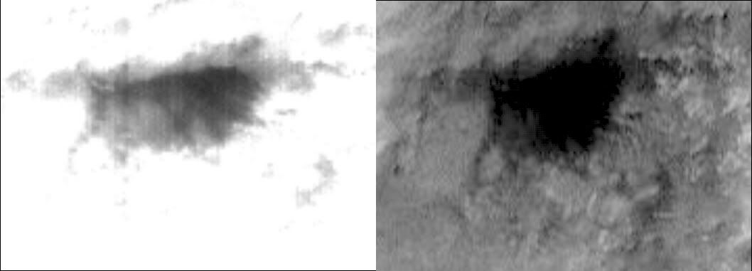
I went back to the original IMG images from MOC. The 0 brightness nature of the 'abyss' only comes from a stretching of the brightness values done on the jpg/gif releases of these images.
These are brightness stretched from the raw images to retain a bit of the detail inside the abyss.
E03-00012:

R02-00357:

Both images are taken with very low sun angles (40 degrees above horizon for E03-00012 and 39 degrees above horizon for R02-00357) which might help explain the shadowed effect.
Note the dark band running across the 'abyss' in the R02-00357 image. R02-00357 was taken 2 years after the first, and shows many dust devil tracks (click the above images to see the larger frames). I wonder if this dark band cutting across the 'abyss' is itself a dust devil track across the dark material in the basin.
Yes There does appear to be some data in the dark area but to me it appears to be dark soil and / or shadow. I'm tempted to see something else but, ..I don't know, we'll just really really have to wait. 
It would be neat to go down there, but right now I just want to get to the top of Husband hill. It would be really cool to park there for a while, take a complete pan in all colors, and send back multiple low compression images of each area in at least one color for super resolution imagery. That would produce one hell of a pan.
Ted
Ted
Someone asked if there is an anaglyph of the Columbia Hills and the "Ultreya Abyss". This is the only one as far as I know:
http://www.marsunearthed.com/Specials/Colu...ltreyaAbyss.GIF
Here's a side by side comparison of some MOC images of the area.
http://www.marsunearthed.com/Specials/Colu...aHillsComp3.JPG
These dark patches, which are spread all over this area, look to me like pockets of dark fine material. It's not clear if this material is local or is blown in from somewhere else. My theory (probably not original) is that there are places where the surface comes into contact with subsurface layers or pockets of dark, fine material which is probably volcanic in origin. This same thing can be seen in other MOC images from other regions.
That was a nice anaglyph of the hills, but the dark end is still saturated. This is no mystery. There is no humongous sinkhole. The unsaturated images show normal topography in the supposed 'abyss.' As far as I can tell, Ultreya Abyss is history.
I'm going to bed, and that's where this topic should be put.
I'm going to bed, and that's where this topic should be put.
I didn't intend to ignore your last paragraph...Right, it is either dark stuff brought in from elsewhere, or dark stuff that has been unearthed, maybe with some help from the shadows.
While were waiting for direct imaging of "Ultreya" to be made hopefully sometime in early 2006, heres a peek at what it might turn out to look like, given that the dark (in some wavelengths) patch on the side of the hill imaged in Spirit images from sol 582...


...would appear to correlate to the same 'dark' area near the top of the mgs images below.
So, just a bunch of 'dark' soils? (even so, that 'dark' soil... whats it? why in these patches? doesnt seem associated with any conspicuous outcrop...)

...would appear to correlate to the same 'dark' area near the top of the mgs images below.
So, just a bunch of 'dark' soils? (even so, that 'dark' soil... whats it? why in these patches? doesnt seem associated with any conspicuous outcrop...)
We're at the border and it's...dark...
http://i16.photobucket.com/albums/b14/ustr...treyaborder.jpg
How...darker can it get?
http://i16.photobucket.com/albums/b14/ustr...treyaborder.jpg
How...darker can it get?
There is detail in the dark. A little ImageJ magic reveals:
The two images are not for xeyed 3d but just to compare ground features
The two images are not for xeyed 3d but just to compare ground features
My own personal opinion, at this point, is that Ultreya represents an ancient impact into the land that now makes up the Columbia Hills. It's a roughly circular depression, and while there are several ways to make those on Mars, by far the most common is impact cratering.
The next question is, why is there so much dark material in this depression, and why does it seem to sweep out of a linear contact along the north-northwest edge of Ultreya? My best guess is that the Ultreya impact excavated a bed of very dark material (either a continuous bed that is also exposed a few other places in the Hills, or a relatively small dark deposit). Wind comes in to the depression, swirls around in a clockwise direction, and over millions of years has eroded the very dark dust from this contact and strewn it along feather-like arcs toward the east-southeast.
So, I am *really* looking forward to seeing the side of Ultreya that will remain obscured the longest... because that's where this contact appears to be located.
-the other Doug
QUOTE (dvandorn @ Aug 26 2005, 02:47 PM)
My own personal opinion, at this point, is that Ultreya represents an ancient impact into the land that now makes up the Columbia Hills. It's a roughly circular depression, and while there are several ways to make those on Mars, by far the most common is impact cratering.
Hi Doug,
Ok but what about all those very dark nodules scattered around in front of Ultreya?
Could they be eaten and brunt bones chucked out by a martian fire breathing dragon that lives under Columbia Hills?

Those dark "nodule"-like boulders are arrayed on the southern "rim" of the Ultreya depression, are they not? They could well be what remains of the contact with the dark material on the southern side of the Ultreya "crater".
If there is a deposit of dark material, it's likely that it's larger than just the tiny patch that happens to be exposed in the northern wall of Ultreya, after all.
As for Dragons -- when I see unequivocal evidence of thoat tracks on Mars, I'll start believing in Martian dragons...
-the other Doug
If there is a deposit of dark material, it's likely that it's larger than just the tiny patch that happens to be exposed in the northern wall of Ultreya, after all.
As for Dragons -- when I see unequivocal evidence of thoat tracks on Mars, I'll start believing in Martian dragons...
-the other Doug
But what about all the other 'dark' areas...
They are just as dark, almost as large, and look almost as intriguing as "Ultreya" does from orbit.
And now, a couple such areas have already been imaged from Spirit and so it gives us the insight into the composition of the dark areas, which from the orbital images look very similar.
Im still betting "Ultreya" will be some rocky outcrops surrounded by dark sands...
...but I might be surprised when we find a bunch of free-range chickens feeding off the scraps tossed from the lair of the Columbia Hills Dragon.
reefer to my earlier post #43: http://www.unmannedspaceflight.com/index.p...opic=585&st=30#
Just for the record, here's what I believe is the area where Ultreya lays:
http://i16.photobucket.com/albums/b14/ustrax3/est.jpg
http://i16.photobucket.com/albums/b14/ustrax3/est.jpg
This is a "lo-fi" version of our main content. To view the full version with more information, formatting and images, please click here.