So, I think we can say now that we are in post-EDL operations, now that the solar panels have been verified. Still on the list of things to come:
1. Full panoramic from Phoenix, I would expect it to be coming in pieces over the next day, every hour and a half or so.
2. Imagery from HiRISE and possible Mars Express, which might show Phoenix while landing. The odds of success are slim, but it sure would be cool!
3. Imagery of HiRISE on it's landing spot. I find this unlikely to come by this Wednesday release, for a few reasons. First of all, it's likely due to a late parachute opening that Phoenix overshot it's landing a bit. If it overshot it far enough, then it would miss a HiRISE window (Remember, the FOV on HiRISE isn't that high...) Secondly, it takes about 4 advanced notice to change an image location, so the next opportunity won't be for a while. Given also the length of a downlink, I put a HiRISE image for the 4th of June.
Anyways, please post your topics on Sol 1 (Or is it 0) of Phoenix. I have a hunch we'll have to do a post for each of the first few days, but...
By the way, for those trying to see the Phoenix Images, and want to download the JPGs, look at http://phoenix.lpl.arizona.edu/ , and then click view images now, then the image you want, then look at the right. You will see an area to download the image now, in JPG format.
Full Version: First day
I believe they're calling this Sol 0.
Congratulations to NASA, JPL and the entire Phoenix team.
And congratulations also to Rui and his judges for choosing Doug's illustration as their contest winner. Doug nailed it, and Rui recognized it.
Congratulations to NASA, JPL and the entire Phoenix team.
And congratulations also to Rui and his judges for choosing Doug's illustration as their contest winner. Doug nailed it, and Rui recognized it.
QUOTE (tuvas @ May 26 2008, 04:31 AM) 
So, I think we can say now that we are in post-EDL operations
Most definitely

I have to leave to get a plane in a few minutes, kuddos to you all.
Whouuuuuuuuaaaa, we're on a NEW Mars again
The upper soil seams to be soft enough. Have you seen how "dirty" the foot is ?
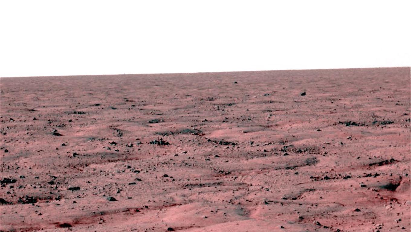
You know, I think one thing we've learned is that each landing from now on is in fact going to be a "new Mars". The Viking rocky desolate stereotype appears to have been broken decisively.
This place feels very, very different. It looks like a mine dump, but this place is not what it appears to be at first glance by any means. Our first alien tundra...
This place feels very, very different. It looks like a mine dump, but this place is not what it appears to be at first glance by any means. Our first alien tundra...
QUOTE (nprev @ May 26 2008, 03:47 AM)
The Viking rocky desolate stereotype appears to have been broken decisively.
Yeah? Go look at Ant's colourisation on the other thread... it's stunning...!!
Indeed it is!  I was talking about big, huge freakin' rocks like there are around V1 & V2. (BTW, anybody ever sit back & think just how incredibly lucky we were for BOTH of those? Each lander came within mere meters of rocks big enough to destroy them, and to this day we don't know what sort of stony daggers are pointed against their bellies, nor how far away they are from vital areas...)
Others have commented on the weathered appearance of the rocks around Phoenix. Could repeated CO2 deposition/sublimation do this, or is the wind perhaps a little more constant in Vastitas Borealis? Sure looks like there's nothing to stop it...
I was talking about big, huge freakin' rocks like there are around V1 & V2. (BTW, anybody ever sit back & think just how incredibly lucky we were for BOTH of those? Each lander came within mere meters of rocks big enough to destroy them, and to this day we don't know what sort of stony daggers are pointed against their bellies, nor how far away they are from vital areas...)Others have commented on the weathered appearance of the rocks around Phoenix. Could repeated CO2 deposition/sublimation do this, or is the wind perhaps a little more constant in Vastitas Borealis? Sure looks like there's nothing to stop it...
Truly beautiful..... I think Peter Smith will have a hard time deciding where to dig.... at small scales what a wonderful cornucopia to delve into....
Hard to believe how worried we were just a few hours ago.... now Phoenix is in it's element, to do what it is designed to do... congrats to that entire team....
Luv it!!!!!
Can't wait for the Sol 0 press briefings for tonight and into tomorrow...
Craig
Hard to believe how worried we were just a few hours ago.... now Phoenix is in it's element, to do what it is designed to do... congrats to that entire team....
Luv it!!!!!
Can't wait for the Sol 0 press briefings for tonight and into tomorrow...
Craig
So, last pic, after, I will go to bed.
A mosaic from 4 pic (always very approximative in colors).
A mosaic from 4 pic (always very approximative in colors).
Beautiful as always, Ant; thank you!
Anybody notice that rock about midway up the field in the near distance? It looks like an owl staring at Phoenix (shameless attempt to name a rock, here... )
)
Anybody notice that rock about midway up the field in the near distance? It looks like an owl staring at Phoenix (shameless attempt to name a rock, here...
)
QUOTE (nprev @ May 25 2008, 07:07 PM)
Anybody notice that rock about midway up the field in the near distance? It looks like an owl staring at Phoenix
Exactly how much beer did you say you had?
--Greg :-)
To all UMSFers,
What a great evening (east coast US)!
The pictures coming down are a wonderful surprise.
The colorized versions from you guys are amazing!
What a great community!
Thanks to JPL, UA, and all of you!
What a great evening (east coast US)!
The pictures coming down are a wonderful surprise.
The colorized versions from you guys are amazing!
What a great community!
Thanks to JPL, UA, and all of you!
QUOTE (Greg Hullender @ May 25 2008, 08:19 PM)
Exactly how much beer did you say you had?
Apparently somewhere between not enough & too much! No miniBigfoots in evidence, though...
Whatever that light-colored "splinter" is in the one horizon view, in the mid-to-far field between us and a bump on the horizon, it's real. It casts a shadow that is plainly visible beyond it. And it really does appear to be as skinny as it looks.
My bet is that it's the heatshield, which sliced into the ground edge-on.
-the other Doug
My bet is that it's the heatshield, which sliced into the ground edge-on.
-the other Doug
Is it my imagination or could one of the landing pod legs landed on a sheet/slab of ice?
http://www.nasa.gov/images/content/229920m...8_10C96L1M1.jpg
http://www.nasa.gov/images/content/229920m...8_10C96L1M1.jpg
Cool thought, oDoug! I'd been regarding it as an artifact; can hardly wait to see the second look!
The Other Doug,
It could be a flare effect that we see in many MER shots of very reflective objects, but I am in agreement with you that that is a man made object.
I can wait to get the calibrated (vs. JPG) images to play around with!
It could be a flare effect that we see in many MER shots of very reflective objects, but I am in agreement with you that that is a man made object.
I can wait to get the calibrated (vs. JPG) images to play around with!
Heatshield having done an opportunity I think. If it were the backshell, we'd have a parachute next to it.
Doug
Doug
Yeah, that was my thought, Doug. I thought about lens flare and cosmic ray hit, too -- but the thing casts a shadow. Lens flares don't cast shadows.
-the other Doug
-the other Doug
red/blue <whatever the real wavelengths are...> color, no balancing to get "natural".... just showing the most detail.
Ed,
where are the filter numbers used in each image?
where are the filter numbers used in each image?
What a great way to start the day! It's about 8 AM here in Italy.
What happens next? I can't find a timetable for the next actions/communication opportunities
At closer look at the artifact near the horizon definately looks like it's an object, it's about 10 pixels in length. The flare reminds me of the shots we have of Opportunity's heat sheild that also caused a significant image flare from the CCD. Perhaps we can get some "super resolution" shots of it, as obviously, we're as close as we can get. I hope the parachute is a little closer.
Did NOT catch the filter numbers, it's pretty obvious which is longwave and which is shortwave. Green filter is a mindless average of "red" and "blue"
I see somebody else posted essentially the same pic. Only difference is I did a "sharpen" on my ver. to "crisp" things up. I have to compsite up the other color pairs. also. Very little in the way of reddish "dust", none of the fine "drifts" as seen at the Viking 2 site, where they were common in polygonal troughs (obviously much younger), though "protected" areas in low spots and between rocks do seem smoother and red, as though there's a thin dust coating in the area.
The surface is pervasively granular, as though 20% of the material was poorly sorted gravel. I'm NOT sure at all that a lot of that stuff is in fact rock, though much of it in the color pic I made up is bluer than the "soils" and clearly is not highly weatered reddish material.
No "duricrust" visible, but 1 frame out of a landing site ain't much.
Re the "object" on the horizon.. it looks too sharp, as though not imaged by the optics. I'm 90% convinced it's just a cosmic ray hit, like gadzillions of'm on the MER rovers.
amazing terrain indeed, but remember we're near the Pole 
Good morning everyone... is there anybody in there?
(Mmm, it looks like there was a party here a few hours ago and now everybody is sleeping.)
It was great to start the morning with such great news! I've just finished reading the threads here at UMSF from the point I left yesterday --yes, I was *sleeping* during EDL. It seems I'm against the mainstream.-- and will now continue on other sites.
Two quick questions:
1. Did NASA already pinpoint the exact location of the Phoenix Lander?
( newsarticle stated: 68.2 North - 234 East )
2. How long before Mars Reconnaissance Orbiter will snatch a photo of the landing area?
Exciting times indeed
the other Phil
1. Did NASA already pinpoint the exact location of the Phoenix Lander?
( newsarticle stated: 68.2 North - 234 East )
2. How long before Mars Reconnaissance Orbiter will snatch a photo of the landing area?
Exciting times indeed
the other Phil
I managed to sleep three hours...
A hard working day ahead...
A hard working day ahead...
Hi,
Here is another false colour knock up job.
Does anyone have a filter guide. I looked around the net for one - but could not find.
Also the images at LPL are not listing their filter numbers so you have to guess what they are with trial and error.
But this came out eventually and does the trick.
Will be interesting to see what the "real" colours are.
I'm guessing there should be color images available in a few hours.
Cheers,
Simon Mansfield
SpaceDaily.com
Congratulations to the Phoenix team! This is certainly terrain for a static lander: homogeneous on scales larger than the polygons.
Half of all the spacecraft to have survived landing on Mars are still active!
This is certainly terrain for a static lander: homogeneous on scales larger than the polygons.Half of all the spacecraft to have survived landing on Mars are still active!
QUOTE (Simon @ May 26 2008, 01:05 AM)
Does anyone have a filter guide. I looked around the net for one - but could not find.
Also the images at LPL are not listing their filter numbers so you have to guess what they are with trial and error.
Also the images at LPL are not listing their filter numbers so you have to guess what they are with trial and error.
Filter characteristics and filename conventions : Phoenix Surface Stereo Imager
As to the exact filenames, they can be found in this gallery at nasa.gov. The web addresses have the filename (eg ...SS000EFF896228409_10CA8R8M1.html) In that example, it's an R8 filter image.
(rubs eyes) Morning everyone...
Wow, I had an AMAZING dream... I dreamed I sat by my computer for, like, 9 hours, jumping in and out of chat rooms and talking with dozens, hundreds of UMSFers and people all around the world, all sharing a love of science and discovery and exploration, all looking forward to, then celebrating, the arrival of a probe at Mars...! I dreamed I sat here, crunching peanuts and watching the expressions on the faces of people in Mission Control change from 'apprehension' to 'fear' and then 'joy'... I dreamed that I leapt into the air as images of a pebble-strewn polar martian plain appeared on my screen, one after the other, dizzyingly fast, to a soundtrack of whoops and cheers and yells of delight...
Anyone else have that dream..?
QUOTE (Stu @ May 26 2008, 10:20 AM)
watching the expressions on the faces of people in Mission Control change from 'apprehension' to 'fear' and then 'joy'... I dreamed that I leapt into the air as images of a pebble-strewn polar martian plain appeared on my screen, one after the other, dizzyingly fast, to a soundtrack of whoops and cheers and yells of delight...
Anyone else have that dream..?
Anyone else have that dream..?
Oh yes
The two things that will linger in the memory are those mentioned above - the tension of the altitude countdown and its reflection in the faces of the team, and the first view. Wonderful stuff; just glad its a Bank Holiday here though I hope Phoenix aint expecting the day off...
It was a great night and made all the better that we all enjoyed the tension and joy together.
That landscape looks so desolate but a mere centimetres below that surface lie such possibilities.
That landscape looks so desolate but a mere centimetres below that surface lie such possibilities.
Given the extremely flat terrain, without obstructions, I'm expecting to see the parachute and backshell lying on the ground when we get photos of the other side of the spacecraft...
The bright object in the distance I'm sure is the backshell inverted to expose the shiny interior, as happened on both Spirit and Opportunity.
QUOTE (Steve G @ May 26 2008, 08:46 AM)
I hope the parachute is a little closer.
I certainly hope it isn't any closer as that might spark another round of: "clearance fever". I hope the chute has pulled the backshell far away.

QUOTE (PhilCo126 @ May 26 2008, 09:51 AM)
Two quick questions:
1. Did NASA already pinpoint the exact location of the Phoenix Lander?
( newsarticle stated: 68.2 North - 234 East )
2. How long before Mars Reconnaissance Orbiter will snatch a photo of the landing area?
Exciting times indeed
the other Phil
1. Did NASA already pinpoint the exact location of the Phoenix Lander?
( newsarticle stated: 68.2 North - 234 East )
2. How long before Mars Reconnaissance Orbiter will snatch a photo of the landing area?
Exciting times indeed
the other Phil
Click to view attachment
I don't know if you have found the answers to your questions but in case you haven't I thought I would give them ago.
1. The red circle on the attached image (taken from Emily's blog) is Phoenixs estimated location and the associated error margin. We were told there is a 90% or so chance of it being in the red circle. Its calculated from the UHF signals and the inertial measurement units on Phoenix. So really they just have a good idea where it is not an exact fix. If you notice its to a large degree outside the blue landing ellipse, the parachute opened 7 seconds after its nominal time. The reason for which is still not known.
2. AS for MRO imaging they will be trying today based on the estimated position and they think they should have Phoenix imaged in just a few days.
What kind of downlink are we expecting in terms of images etc?
I'm so used to the Firehose photostreamTorrent from the rovers that my expectations are probably a bit too high
Congrats to all involved also, Mars is a busy place these days.
I'm so used to the Firehose photo
Congrats to all involved also, Mars is a busy place these days.
What a wonderful night (do you ear the song ? ).
So, an other try with the 3 pointings made probably in red and blue filters. I have made a synthetic green layer to have the RVB trichromy.
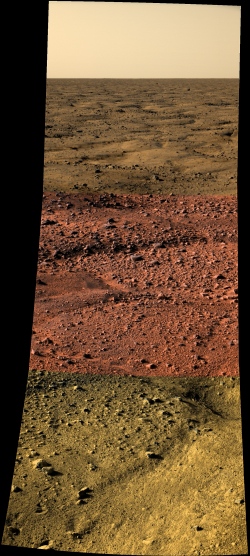
Other pics (solar panels pan and anaglyph of pod) are here, a special page of my website : http://www.astrosurf.com/merimages/Images_de_phoenix.html
? ).So, an other try with the 3 pointings made probably in red and blue filters. I have made a synthetic green layer to have the RVB trichromy.
Other pics (solar panels pan and anaglyph of pod) are here, a special page of my website : http://www.astrosurf.com/merimages/Images_de_phoenix.html
This has been incredible. I was able to follow it on my phone and see the first pics when they were released. I tried to post here, not sure what happened to it. Congratulations to the Phoenix team! 
What a night! I also stayed up until the first pictures came down and went to bed around 4:30 am
That makes working today quite hard.
Thank you everybody for posting these fantastic pics! I am so excited about this new mission and hope to see the first Martian water ice soon!
I just found what seems to be a "true" color image of the horizon, on Spiegel Online:

Source: http://www.spiegel.de/wissenschaft/weltall...,555297,00.html
I could not find it on the NASA pages, however.
Edit: Now I did: http://www.nasa.gov/mission_pages/phoenix/...r_postcard.html
It is an approximate-color image "inferred from two color filters, a violet, 450-nanometer filter and an infrared, 750-nanometer filter".
The colors are very close to what we already know from the two rovers, I think.
Congratulations to the Phoenix-Team! Outstanding job! Can't wait to see more!
Michael
That makes working today quite hard.
Thank you everybody for posting these fantastic pics! I am so excited about this new mission and hope to see the first Martian water ice soon!
I just found what seems to be a "true" color image of the horizon, on Spiegel Online:
Source: http://www.spiegel.de/wissenschaft/weltall...,555297,00.html
Edit: Now I did: http://www.nasa.gov/mission_pages/phoenix/...r_postcard.html
It is an approximate-color image "inferred from two color filters, a violet, 450-nanometer filter and an infrared, 750-nanometer filter".
The colors are very close to what we already know from the two rovers, I think.
Congratulations to the Phoenix-Team! Outstanding job! Can't wait to see more!
Michael
QUOTE (Ant103 @ May 26 2008, 12:28 PM)
Other pics (solar panels pan and anaglyph of pod) are here, a special page of my website : http://www.astrosurf.com/merimages/Images_de_phoenix.html
Ant
Your anaglyph of the pad is just great - is it just me or has Phoenix broken thro' a surface crust? Is that a bit of the ice crust poking up?
Hey people,
I'm one of the hundreds of people that have been lurking here yesterday!
For my first post I have a question: does anyone know what was the event that triggered the parachute deploy? I'm wondering if it was a specific altitude, speed, density, or something else. If it's something like that, then the Martian atmosphere models will have to be recalculated. The 7 seconds delay of the parachute deploy at that speed caused a significant deviation from the center of the landing ellipse.
Folks
Forgive my inorance, or inattention if its already been pointed out, but is it possible to hazard a guess as to the scale involved in the nearby features above ie what is the approx width of the closest of the polygons?
Forgive my inorance, or inattention if its already been pointed out, but is it possible to hazard a guess as to the scale involved in the nearby features above ie what is the approx width of the closest of the polygons?
"Smith said such pithy things as: "I know it looks a little like a parking lot, but that's a safe place to land. That makes it exactly where we want to be. Underneath this surface, I guarantee there's ice. You can see lots of pebbles, and soil, and all these troughs you see in between the polygons. These are probably about 15 feet [5 meters] across."
"This is probably the cutest polygon that I have ever seen...." "
(from Emily's blog)
So, when's the next batch coming?
"This is probably the cutest polygon that I have ever seen...." "
(from Emily's blog)
So, when's the next batch coming?
Excellent, thank you. That makes the front square just about the same size as the patch of lawn I see right now if I look out of my window - really does help to (quite literally!) bring home the magnitude of what has been acheived.
QUOTE (PFK @ May 26 2008, 12:16 PM)
Folks
Forgive my inorance, or inattention if its already been pointed out, but is it possible to hazard a guess as to the scale involved in the nearby features above ie what is the approx width of the closest of the polygons?
Forgive my inorance, or inattention if its already been pointed out, but is it possible to hazard a guess as to the scale involved in the nearby features above ie what is the approx width of the closest of the polygons?
If you go to this page http://fawkes3.lpl.arizona.edu/images.php?gID=440&cID=8 and mouse over an image, the pointing elevation of the camera is shown. From that and the fact that the cameras are situated about 2 m above the surface, plus the knowledge of the field of view of the camera (14°, see here: http://www.lpi.usra.edu/meetings/lpsc2008/pdf/2156.pdf), you can calculate the distances and the scales of the objects (assuming that the lander is level and the ground, too, which it pretty much is).
Distance of the center of the image from the camera:
dc = h / sin(a)
Top
dt = h / sin(-b/2 - a)
Bottom
db = h / sin(b/2 - a)
Where a is the pointing angle (eg. a = -27.1185° for the lowest part of the mosaic), b the field of fiew (b = 14°) and h is the camera height (h = 2 m).
So the center of the lowest frame (see below) has a distance from the camera of about 4 m.
The width of the frame at center is:
wc = 2 d tan(b/2) = 2 h tan(b/2) / sin(a)
So the width of the field is about 1 m and so is the polygon in the lower part of the mosaic. The larger pebbles to the left (image below) are about 5-8 cm in diameter.
I hope I got the maths approximately right. It seems the polygon is a little smaller than said by Smith?
Michael

Great landing, awesome pics, congrats to all involved. Still a bit of a shame to be at the pole without skis! Click to view attachment
Click to view attachment
This is a "lo-fi" version of our main content. To view the full version with more information, formatting and images, please click here.