I was trying to see if "Rolling Rock" correlated to any of the boulders we could see in the Duck Bay pan of Cape Verde. My guess is that the rocks we are seeing are the grouping between D1 and D2. Hopefully from the top of Cape Verde we'll be able to see down to "Rolling Rock" and the trail.
Cropped version of Nix's anaglyph of Cape Verde with MRO view:
Click to view attachment
Full Version: Rocks in the Victoria panoramas
I agree with your identifications, hendric. But it looks like we won't see rolling rock from Verde - according to this navcam shot from sol 959 our view in that direction isn't much better than from our Duck Bay stop, with Beacon cape still blocking our view. I don't think it would help even if we moved as far as we can to the tip of Verde, which is only a few metres.
Perhaps we'll move next onto Beacon cape and we might get a view from there.
Perhaps we'll move next onto Beacon cape and we might get a view from there.
It's interesting that the material trailing out of Victoria is on the North side, where the dunefield is skewed and where most of the rocks appear. Maybe those rocks have all been exhumed? The north side also has steeper-looking cliffs (A,B,C,D,E) vs the south side (H-N).
http://www.physics.usyd.edu.au/~jcanvin/me...ys_jpl_half.jpg
Thanks James for the excellent map!
http://www.physics.usyd.edu.au/~jcanvin/me...ys_jpl_half.jpg
Thanks James for the excellent map!
Are you sure that the northside cliffs are steeper? It could be that the angle of the sun gives that appearance.
From the MOC generated DEM you can tell that the SE slopes are a lot shallower than the NW slopes.
Doug
Doug
QUOTE (hendric @ Oct 12 2006, 03:47 PM) 
It's interesting that the material trailing out of Victoria is on the North side, where the dunefield is skewed and where most of the rocks appear. Maybe those rocks have all been exhumed? ...
The prevailing winds, as suggested by the eroded cliff material dust being blown out of the crater (dark streaks) are probably prompting boulders and rocks to pop out "every so often". If the north side is being exhumed we shoudlnt see boulder tracks, which seems to be there, although maybe they are being removed and the ones we see are actually quite "recent".
Although it is hard to call whether the north side is actually being exhumed or buried, the offset of the dunefield as you say, towards the north seems to suggest that it is indeed being exhumed, or at least part of it being that the south side in the cliff's wind shadow is being buried as much.
QUOTE (djellison @ Oct 13 2006, 07:40 PM)
From the MOC generated DEM you can tell that the SE slopes are a lot shallower than the NW slopes.
Doug
Doug
Hopefully the truth of this will be borne out by the forthcoming hirise stereo image. Do you know when it is scheduled to be taken?
Here's a nice image:
http://marsrovers.jpl.nasa.gov/gallery/pre...-B993R1_br2.jpg
http://marsrovers.jpl.nasa.gov/gallery/pre...-B993R1_br2.jpg
Here's a little mystery -- to me at least.
What is this latest pancam image of? (Dated 10/24)
If I didn't know better I'd say it was taken from the crater floor, but all the other reasons (many!) that this is unlikely aside, the other thumbnails and such sent on 10/24 are clearly taken from the rim.
Can anyone put this pic into context for me?
Click to view attachment
Looks familiar...Endurance?
Nico
Nico
Just a bit of the Duck Bay pan looking toward just beyond the end of C.V.
Doug
Doug
QUOTE (djellison @ Oct 25 2006, 05:00 PM)
Just a bit of the Duck Bay pan looking toward just beyond the end of C.V.
below and slightly left of center in this view:
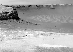
Here is the navcam view to show that area in context.
http://marsrovers.jpl.nasa.gov/gallery/all...VP0657L0M1.HTML
http://marsrovers.jpl.nasa.gov/gallery/all...VP0657L0M1.HTML
Does anyone else think that the following image contains a "rolling rock" trail? Just below dead centre there appears to be a series of bounce marks and then they stop at a largish rock.
http://www.lyle.org/mars/imagery/1P2229145...57R2M1.JPG.html
Cheers
Brian
http://www.lyle.org/mars/imagery/1P2229145...57R2M1.JPG.html
Cheers
Brian
Yup - almost certainly - we can see several from orbit as well.
Doug
Doug
Brian:
Possible yours, *and* another one!
Click to view attachment
It could be some sort of wind effect, though (remember the size and length of 'Serpent'?) with a series of eddies behind a rock.
Bob Shaw
Possible yours, *and* another one!
Click to view attachment
It could be some sort of wind effect, though (remember the size and length of 'Serpent'?) with a series of eddies behind a rock.
Bob Shaw
Hi Bob,
It is just that similar sized rocks closeby have no trails (of eddies or bounce marks). I will see if I can match up with some other pictures from further round the crater.
Cheers
Brian
It is just that similar sized rocks closeby have no trails (of eddies or bounce marks). I will see if I can match up with some other pictures from further round the crater.
Cheers
Brian
Well - other rocks may have done the same thing, but long enough ago that the bounce marks have since been blown to nothing by the wind. Given that rover tracks were blown to nearly nothing within a year, this wouldn't be suprising.
Doug
Doug
Yep, those are boulder trails, and they've been visible for some time now. 
QUOTE (djellison @ Jan 26 2007, 03:34 PM)
Well - other rocks may have done the same thing, but long enough ago that the bounce marks have since been blown to nothing by the wind. Given that rover tracks were blown to nearly nothing within a year, this wouldn't be suprising.
Lots of confounding factors though; different wind speeds from out on the plain, probably different sediment loads, differently size holes... Come to think of it, the rover tracks would be (originally) sharp edged troughs; the sharp edges would be the first to disappear, both as the "lip" blurs and the bottom corners are the first to fill, so the tracks might be effectively invisible after a relatively short time. I bet the deeper tracks would still be visible to the naked eye the ground, but as parallel shallow linear depressions with soft edges and a smoothly contoured cross-section. Boulder bounce or roll marks would be naturally concave to start with, er... so perhaps boulder track's recent after all.
Personally I'm hoping both rovers survive a long time even after becoming immobile, like the Vikings. It would be great if nature could arrange for the inevitable final wheel-killing events to leave us high up on a nice north-facing slope in the middle of a wind or DD alley so we could watch those sort of processes over longer time periods, as well as watch for low frequency events like impacts and boulder falls from steep slopes, as Odyssey managed to successfully.
Speaking of rocks and winds and such-like, the latest batch of NavCams Cape Desire Nav seem to show the concretions forming very clear ripple/windrow patterns as we tiptoe toward the tip of the prominence. If I read the pattern correctly, stronger winds than hitherto seen elsewhere are blowing out of the crater, over the tip, and off to the northwest. (The same direction as the dark streaks up ahead.) Farther away from the brink, the blueberries were much more scattered in their pattern, implying weaker and/or less directional prevailing winds. It's possible that the average wind velocity (now or in the not-too-distant past) is increasing as we get closer to the streak area. I wonder if the blueberry ripples (hmm...make a nice ice cream flavor! ) will continue to increase in density, amplitude, sorting and 'cleanliness'? That could explain the lower albedo. I'm feeling more content as a "Clean Streaker" these days. 
Opinions?
) will continue to increase in density, amplitude, sorting and 'cleanliness'? That could explain the lower albedo. I'm feeling more content as a "Clean Streaker" these days. Opinions?
Hi, new to the forum. Glad I found it, as I've had no one else IRL to talk to about MER, and Mars in general. I've assumed too that the dark streaks indicate strong winds coming up from the bays. Any comments on the possibility/effectiveness of taking a small drive into one of those bays, maybe C5/D1 (the first dark streak) and using the strong wind (if it's blowing through at the time) to clean some of the dust off of the solar panels?
n1loc
n1loc
Welcome in the Forum, n1loc!
I think Oppy doesn't actually need such a risky cleaning, while would be great if her sister in Gusev would have a similar "opportunity"...
I think Oppy doesn't actually need such a risky cleaning, while would be great if her sister in Gusev would have a similar "opportunity"...
Willkommen, bienvenue, welcome!
Fremde, etranger, stranger, (mind if I call you n1?)
I have little doubt that, if there are any cleansing winds funneling out of those bays up ahead when we get there, JPL will give them a chance to tidy up Oppy. We will need maximal efficiency in the solar collectors whenever we hazard to descend into the crater, since there will be increased likelihood of unfavorable tilting and shading down below.
Of course if the winds are loaded with black "dirt" ("Dirty Streaker Hypothesis"), then we may want to waste no time in the area, but move on into the clear beyond.
Didn't know where to put this...
This one looks quite interesting, lots of stuff embeded into it.
Does anyone have an idea of what type of rock this might be?
Tesheiner...Does it have a name?
This one looks quite interesting, lots of stuff embeded into it.
Does anyone have an idea of what type of rock this might be?
Tesheiner...Does it have a name?
Yeah, I saw that too, ustrax. Looks like it's got some sort of a hole that got filled up with dirt...volcanic, or yet another meteorite?
Looks like a crystal to me. Most surfaces are flat. Apart from the hole, the bright mark above it looks interesting. It looks like the rock was scratched just recently. Can it be the rover's wheel?
I'd have to say that it's either a breccia or a welded ashflow tuff. In either case, the rock matrix could very well be crystalline, since it started out as a rock melt. The rock fragments embedded in it were caught up in the rock melt, but didn't melt themselves (though some of them may have partially melted, and all were probably altered).
Since breccias are most commonly formed by impacts (the impact melts some of the target rock, and that melt incorporates cooler fragments of other rocks as it travels through its trajectory), and we're on the ejecta blanket of a reasonably large crater, I'd say that Occam's razor suggests this is a small breccia.
-the other Doug
It's just a guess since we don't have much to go on, but doesn't this cobble have some similarities to the well studied Santa Catarina and the many similar cobbles lying about? The hole seems to be filled with dust or dirt, but a vesicle of that size is an interesting observation. I wonder how they spotted it.
Yes, Tom, the one hole on the top does seem to be dust-filled, but the rock has several other clasts. Most of them just seem to have eroded at the same rate as the matrix.
I'd have to say it's definitely a clastic rock, and that means it's either an aggregate, a breccia or a welded ashflow tuff. And it doesn't look like an aggregate to me.
-the other Doug
I'd have to say it's definitely a clastic rock, and that means it's either an aggregate, a breccia or a welded ashflow tuff. And it doesn't look like an aggregate to me.
-the other Doug
I remember being surprised when Santa Catarina was identified as a meteorite, so I did a little reading to learn about meteorites that contained lithic fragments. There are certain types of chondrites that contain a variety of lithic fragments or clasts that are indicative of processes that formed the parent body. ...fascinating stuff...
I guess we don't truly know that this is the same stuff, but it appears to be.
I guess we don't truly know that this is the same stuff, but it appears to be.
This is a "lo-fi" version of our main content. To view the full version with more information, formatting and images, please click here.