Help - Search - Members - Calendar
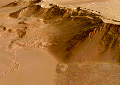
Full Version: New Olympus Mons image
Unmanned Spaceflight.com > Mars & Missions > Orbiters > Mars Express & Beagle 2
SigurRosFan
http://www.esa.int/SPECIALS/Mars_Express/SEMIPVMVGJE_0.html - Eastern scarp of Olympus Mons (Press Information)

http://www.esa.int/SPECIALS/Mars_Express/SEMIPVMVGJE_1.html - Eastern scarp of Olympus Mons (Images)

Image was taken on Nov. 23, 2004:


Lava flows are up to 200 million years old and the network-bearing area was geologically active as recent as 30 million years ago.
Richard Trigaux
I alway wondered where this huge scarp is coming from... This is an unique feature in all the shield volcanoes. It cannot result from volcanic activity itself, and it is clear on the picture that the more recent lava flows are above it. It is a bit as if there was a piece of land lifted up, coinciding witht he volcano shield.

One of my favorite hypothesis is that there were huge landslides all around Olympus Mons, due to some rain or moisture which reached a certain altitude, but left the highest parts. Some say it was rather glacial activity. But in any way it is strange that this scarp is just at the bottom of the volcano slope.
SigurRosFan
QUOTE
I alway wondered where this huge scarp is coming from... This is an unique feature in all the shield volcanoes.

It is a unknown surface phenomenon of shield volcanoes? huh.gif
Decepticon
I remember reading Olympus Mons is not the tallest feature on Mars?


Is this true?
Jyril
No, Olympus Mons is the tallest mountain.

I remember there was a claim many years ago that Arsia Mons could be higher than Olympus Mons. Obviously that wasn't true.
Nix
Amazing images ohmy.gif

Nico
David
Olympus Mons is so huge that you could probably land a rover on it, and nothing that the rover could show you would even tell you that you were on a mountain.

I know -- let's do it! laugh.gif
Richard Trigaux
QUOTE (Richard Trigaux @ Mar 3 2006, 04:38 PM) *
I alway wondered where this huge scarp is coming from... This is an unique feature in all the shield volcanoes. It cannot result from volcanic activity itself, and it is clear on the picture that the more recent lava flows are above it. It is a bit as if there was a piece of land lifted up, coinciding witht he volcano shield.

One of my favorite hypothesis is that there were huge landslides all around Olympus Mons, due to some rain or moisture which reached a certain altitude, but left the highest parts. Some say it was rather glacial activity. But in any way it is strange that this scarp is just at the bottom of the volcano slope.


Part of the mystery of Olympus Mons art these strange formations in the north west of it: large spans of terrain which look as it was cut by many crisscrossing faults, the overal form of these spans suggesting a flow.

Maybe there was here some special tectonic, which raised Olympus Mons and produced these terrains, a kind of local or reduced plate tectonics. Anyway there is a huge mystery.
edstrick
MOLA proved that Arsia or one of the 3 tharsis volcanoes is a bit higher than Olympus, but Olumpus is much taller above it's base.
Richard Trigaux
QUOTE (edstrick @ Mar 5 2006, 08:48 AM) *
MOLA proved that Arsia or one of the 3 tharsis volcanoes is a bit higher than Olympus, but Olumpus is much taller above it's base.


Olympus Mons is much more voluminous than any other marsian volcano. Its overal diametre is huge.

Perhaps if Olympus Mons was raised by some tectonic process, this volume is in fact much smaller.

But why a tectonic process would have cut a piece of terrain just the shape and size on the volcano? Because there was (is) a magmatic chamber just that size?
edstrick
There's clear evidence for catastrophic landslides off parts of the basal scarp. Whether the "Olympus Mons Aureole" terrains on the northwest to southwest sides are catastrophic land-slide deposits is much less than clear. There's gravity anomalies over some of them that suggests underlying magma bodies or something. It's all very strange.
tty
Huge peripheral landslides may be a quite normal process for large shield volcanoes. Quite a few have occurred around the Hawaian islands which of course are the largest shield volcanoes on Earth, though the vidence is mostly underwater and therefore difficult to study. This may be a case where Martian geology can throw light on geological processes here on Earth.

Incidentally understanding how and when those Hawaian megaslides occur is highly important since they cause tsunamis orders of magnitude larger than the recent one in the Indian Ocean.

tty
edstrick
One of the mid-sized Hawiian islands has coral chunks at some elevation like 1 or 1.5 km high on the side of a volcano where it faces another islands across that open water between several islands.....

Tossed there by a landslide tsunami.

The term for that is a "Bad Day".
Richard Trigaux
QUOTE (tty @ Mar 5 2006, 06:28 PM) *
Huge peripheral landslides may be a quite normal process for large shield volcanoes. Quite a few have occurred around the Hawaian islands which of course are the largest shield volcanoes on Earth, though the vidence is mostly underwater and therefore difficult to study. This may be a case where Martian geology can throw light on geological processes here on Earth.

Incidentally understanding how and when those Hawaian megaslides occur is highly important since they cause tsunamis orders of magnitude larger than the recent one in the Indian Ocean.

tty


I have read an article recently on such landslides, with a map. It seems that they are all around the islands, but at random, not forming a regular shape. In more, the overal slope of hawai islands seems stronger undersea than above sea. This can be explained as basaltic lava flows cool more quickly under water than above, so they make stronger slopes and then more prone to landslides. If this explanation is true, it don't fit for Olympus Mons. I don't see any example of basaltic shield volcanoes having landslides. Landslides happen in free air, on Earth, for composite volcanoes, like Mount Shasta, but the overal slope is stronger than with a basaltic volcano.
Richard Trigaux
QUOTE (edstrick @ Mar 5 2006, 10:26 AM) *
There's clear evidence for catastrophic landslides off parts of the basal scarp. Whether the "Olympus Mons Aureole" terrains on the northwest to southwest sides are catastrophic land-slide deposits is much less than clear. There's gravity anomalies over some of them that suggests underlying magma bodies or something. It's all very strange.


I was not thinking of landslides for the aureole terrains. Landslides usually are flat or with soft hummocks. Here we have sharp hills, as if crisscrossed by faults with two different angles.


My feeling is that it suggests some plate tectonic shapes, for instance if you look between patagonia and Antartica, on a undermarine map, you see an huge arc of mountains, with islands like Falklands, South Georgia, South Sandwich, etc. This arc strongly suggests a flow, and it is indeed one, the pacific plate pushing through the Alantic plate, through the opening between South America and Antarctic. Also in ocean bottoms we often have crisscrossed terrains.

Would it be possible that we have here a magma chamber huge enough to have a plate tectonics on its surface????? And if so, why Olympus Mons is not sinking into it? The only explanation is that the pressure under this huge volcano forbids the melting of lava, so the terrain remains firm under the volcano. But its lower parts were taken appart by this strange local tectonics, creating this so huge scarps, which fits exactly the contour of the volcano.

The only experience we have on Earth of large magma chambers is that of the Yellowstone, but it don't seems to exhibit any tectonics. In more, on Earth, the roof of huge magma chambers turns upside down in a very short ime, leading to a giant explosion. It don't create a shield volcano. So in the case of Mars, Olympus Mons would be necessarily older than the aureole terrains, and extinct since their appearance.


I cannot explain it, but my intuition alway suggested Mars had not an overal mantle like Earth. The solidification of the planet would have solidified the mantle, but radioactive elements ould have concentrated in the last pockets of fluid terrain. So they formed isolated magma chambers, not an overal mantellic magma like on Earth. With time, such magma chambers would climb and arrive in the surface. When it does, it could create a local plate tectonics. There would be one under Olympus Mons, which created it in the past, the largest, the most active, and the faster now arrived at the surface. But others would be in other places, still climbing, especially in Elysium, or also others in Tharsis.

Evidence of this would be obtained in studying radioactive elements in Olympus Mons and Aureole terrains. A priority target for a large rover able to drice hundreds of kms?
Richard Trigaux
Googling ""Olympus Mons Aureole" (with the "") gives a wealth of info on the aureole terrains. most people seems to think they are indeed landslides. But if so, why they cut so preciselly the contour of the volcano? Perhaps at a precise distance of the main crater; the lava flows were cooler, and thus they constructed a less cohesive terrain, landlide prone, where the central terrain is not.


I especially select this one


give extensive details about the evidences of landslides, and how they could have occured, and why they follow the contour of the volcano.
ljk4-1
This image of an area near Olympus Mons reminds me of some of the
images of Io taken by Galileo:

http://www.msss.com/mars_images/moc/2006/05/07/
djellison
Just out of pure curiosity, I found the orig. data for the Ol.Mons MEX image - this is the full res colour image. Obviously, the ESA releases are the higher res ( typically 4x higher res, sometimes a lot more ) ND channel 'colourised' by the lower res colour data attached.

Doug
Phil Stooke
Nice one, Doug - look at the cloud shadows! If the sun elevation is known the cloud height can be calculated.

Phil
djellison
Unfortunately, ESA being ESA - they've not gone that far....

CODE
/* FILE DATA ELEMENTS */

RECORD_TYPE                       = FIXED_LENGTH
RECORD_BYTES                      = 761
FILE_RECORDS                      = 9093
LABEL_RECORDS                     = 13

/* POINTERS TO DATA OBJECTS */

^IMAGE_HEADER                     = 14
^IMAGE                            = 24

/* IDENTIFICATION DATA ELEMENTS */

FILE_NAME                         = "H1089_0000_GR3.IMG"
DATA_SET_ID                       = "MEX-M-HRSC-5-REFDR-MAPPROJECTED-V1.0"
DETECTOR_ID                       = MEX_HRSC_GREEN
EVENT_TYPE                        = "MARS-REGIONAL-STEREO-Vo-Te"
INSTRUMENT_HOST_ID                = MEX
INSTRUMENT_HOST_NAME              = "MARS EXPRESS"
INSTRUMENT_ID                     = HRSC
INSTRUMENT_NAME                   = "HIGH RESOLUTION STEREO CAMERA"
MISSION_NAME                      = "MARS EXPRESS"
MISSION_PHASE_NAME                = MR_Phase_3
PROCESSING_LEVEL_ID               = 3
PRODUCT_CREATION_TIME             = 2006-02-25T19:37:42.000Z
PRODUCT_ID                        = "H1089_0000_GR3.IMG"
RELEASE_ID                        = 0014
REVISION_ID                       = 0000

/* TIME DATA ELEMENTS */

SPACECRAFT_CLOCK_START_COUNT      = "1/0049306128.57946"
SPACECRAFT_CLOCK_STOP_COUNT       = "1/0049306423.01508"
START_TIME                        = 2004-11-23T16:09:25.323Z
STOP_TIME                         = 2004-11-23T16:13:19.412Z

/* ORBITAL DATA ELEMENTS */

ASCENDING_NODE_LONGITUDE          = 205.87
MAXIMUM_RESOLUTION                = 90.9 <m/pixel>
FOOTPRINT_POINT_LATITUDE          = (27.9346,27.9344,27.9342,27.933,27.9328
                                     ,27.9316,27.9314,27.9301,27.9299,
                                     27.9286,27.9283,27.9269,27.9266,27.9252
                                     ,27.9247,27.9234,27.9231,27.9228,
                                     27.9215,27.921,27.9196,27.919,27.9167,
                                     27.9164,27.9134,27.913,27.9111,27.9107,
                                     27.9088,27.9084,27.9067,27.9064,27.9044
                                     ,27.7339,27.5671,27.4003,26.8988,
                                     26.7313,26.2345,25.9094,25.7463,25.5834
                                     ,22.5711,22.417,22.1085,21.7999,21.4907
                                     ,21.3364,21.1872,21.0395,20.8898,
                                     20.7401,20.5905,20.4405,20.2907,19.9912
                                     ,19.8414,19.5414,19.3913,19.0908,
                                     18.9434,18.7981,18.508,18.3624,18.217,
                                     18.0725,17.9272,17.6366,17.4909,17.3452
                                     ,17.1992,17.0528,16.9066,16.7605,
                                     16.6142,16.4681,16.3218,16.0295,15.8825
                                     ,15.7404,15.5991,15.4583,15.3155,
                                     15.1743,14.7515,13.7638,13.0574,12.6363
                                     ,12.6364,12.6373,12.6375,12.6378,12.638
                                     ,12.6423,12.6424,12.6449,12.6464,
                                     12.6465,12.648,27.9346)
FOOTPRINT_POINT_LONGITUDE         = (231.495,231.482,231.469,231.392,
                                     231.379,231.301,231.288,231.21,231.197,
                                     231.119,231.106,231.028,231.015,230.936
                                     ,230.909,230.844,230.831,230.817,
                                     230.751,230.725,230.659,230.632,230.526
                                     ,230.512,230.379,230.365,230.285,
                                     230.271,230.19,230.176,230.109,230.095,
                                     230.088,230.096,230.103,230.11,230.13,
                                     230.136,230.156,230.169,230.174,230.18,
                                     230.279,230.284,230.294,230.304,230.313
                                     ,230.319,230.325,230.336,230.34,230.344
                                     ,230.348,230.351,230.356,230.365,230.37
                                     ,230.379,230.383,230.39,230.393,230.396
                                     ,230.403,230.405,230.407,230.414,
                                     230.418,230.425,230.427,230.43,230.431,
                                     230.431,230.432,230.433,230.434,230.435
                                     ,230.436,230.44,230.438,230.434,230.434
                                     ,230.436,230.429,230.43,230.435,230.446
                                     ,230.452,230.456,230.464,230.543,
                                     230.553,230.583,230.593,231.0,231.009,
                                     231.285,231.462,231.472,231.478,
                                     231.495)
ORBIT_NUMBER                      = 1089
ORBITAL_ECCENTRICITY              = 0.574
ORBITAL_INCLINATION               = 86.59
ORBITAL_SEMIMAJOR_AXIS            = 8632.71
PERIAPSIS_ALTITUDE                = 282.96
PERIAPSIS_ARGUMENT_ANGLE          = 169.82
PERIAPSIS_TIME                    = 2004-11-23T16:14:01.000Z
SPACECRAFT_ORIENTATION            = (0.0,-1.0,0.0)
^MEX_ORIENTATION_DESC             = "MEX_ORIENTATION_DESC.TXT"
SPACECRAFT_POINTING_MODE          = ACROSSTRACK
^MEX_POINTING_DESC                = "MEX_POINTING_DESC.TXT"
RIGHT_ASCENSION                   = -1e+32
DECLINATION                       = -1e+32
OFFSET_ANGLE                      = -0.62
SPACECRAFT_SOLAR_DISTANCE         = 2.41014e+08
TARGET_NAME                       = MARS

/* CAMERA DATA ELEMENTS */

DETECTOR_TEMPERATURE              = 18.1666 <degC>
FOCAL_PLANE_TEMPERATURE           = 8.1755 <degC>
INST_CMPRS_NAME                   = "DISCRETE COSINE TRANSFORMATION (DCT)"
INST_CMPRS_RATIO                  = 13.4668
INST_CMPRS_QUALITY                = 0
INST_CMPRS_QUANTZ_TBL_ID          = 0
INSTRUMENT_TEMPERATURE            = 10.8262 <degC>
LENS_TEMPERATURE                  = 9.6028 <degC>
MACROPIXEL_SIZE                   = 8
MISSING_FRAMES                    = 0
PIXEL_SUBSAMPLING_FLAG            = N
SIGNAL_CHAIN_ID                   = 2

/* RADIOMETRIC DATA ELEMENTS */

BANDWIDTH                         = 88.0 <nm>
CENTER_FILTER_WAVELENGTH          = 538.0 <nm>
RADIANCE_OFFSET                   = 0.0 <W*m**-2*sr**-1>
RADIANCE_OFFSET                   = 0.999522
RADIANCE_SCALING_FACTOR           = 0.0263032 <W*m**-2*sr**-1>
RADIANCE_SCALING_FACTOR           = 0.0128937
REFLECTANCE_SCALING_FACTOR        = 0.00131548
REFLECTANCE_SCALING_FACTOR        = 0.000644843

/* DATA OBJECT DEFINITIONS */

OBJECT                            = IMAGE
  INTERCHANGE_FORMAT              = BINARY
  LINES                           = 9070
  LINE_SAMPLES                    = 761
  SAMPLE_TYPE                     = UNSIGNED_INTEGER
  SAMPLE_BITS                     = 8
  BANDS                           = 1
  BAND_STORAGE_TYPE               = BAND_SEQUENTIAL
  MAXIMUM                         = 163
  MEAN                            = 89.6954
  MINIMUM                         = 38
  STANDARD_DEVIATION              = 7.2111
END_OBJECT                        = IMAGE

/* MAP OBJECT DEFINITIONS */

OBJECT                            = IMAGE_MAP_PROJECTION
  ^DATA_SET_MAP_PROJECTION_CATALOG= "DSMAP.CAT"
  A_AXIS_RADIUS                   = 3396.19 <km>
  B_AXIS_RADIUS                   = 3396.19 <km>
  C_AXIS_RADIUS                   = 3396.19 <km>
  CENTER_LATITUDE                 = 0.0
  CENTER_LONGITUDE                = 231.0
  COORDINATE_SYSTEM_NAME          = PLANETOGRAPHIC
  COORDINATE_SYSTEM_TYPE          = "BODY-FIXED ROTATING"
  EASTERNMOST_LONGITUDE           = 231.495
  FIRST_STANDARD_PARALLEL         = "N/A"
  LINE_FIRST_PIXEL                = 1
  LINE_LAST_PIXEL                 = 9070
  LINE_PROJECTION_OFFSET          = 16560.6875
  MAP_PROJECTION_ROTATION         = 0.0
  MAP_PROJECTION_TYPE             = SINUSOIDAL
  MAP_RESOLUTION                  = 592.746965121889 <pixel/degree>
  MAP_SCALE                       = 0.1 <km/pixel>
  MAXIMUM_LATITUDE                = 27.9346
  MINIMUM_LATITUDE                = 12.6363
  POSITIVE_LONGITUDE_DIRECTION    = EAST
  REFERENCE_LATITUDE              = "N/A"
  REFERENCE_LONGITUDE             = "N/A"
  SAMPLE_FIRST_PIXEL              = 1
  SAMPLE_LAST_PIXEL               = 761
  SAMPLE_PROJECTION_OFFSET        = 483.4375
  SECOND_STANDARD_PARALLEL        = "N/A"
  WESTERNMOST_LONGITUDE           = 27.9346
END_OBJECT                        = IMAGE_MAP_PROJECTION

/* IMAGE HEADER DATA ELEMENTS */

OBJECT                         = IMAGE_HEADER
HEADER_TYPE                   = VICAR2
INTERCHANGE_FORMAT            = ASCII
BYTES                         = 7610
^DESCRIPTION                  = "VICAR2.TXT"
END_OBJECT                     = IMAGE_HEADER
END
Bob Shaw
QUOTE (Phil Stooke @ May 10 2006, 08:05 PM) *
Nice one, Doug - look at the cloud shadows! If the sun elevation is known the cloud height can be calculated.

Phil


Phil:

I can't remember actually noticing *any* cloud shadows on Mars before these - lots of clouds, but no shadows...

...funny, that!

Bob Shaw
helvick
QUOTE (Phil Stooke @ May 10 2006, 08:05 PM) *
Nice one, Doug - look at the cloud shadows! If the sun elevation is known the cloud height can be calculated.

Well from plugging the average time given for the image (2004-11-23 16:11:22) Latitude (20.2913N) and longitude (-230.7915W) into mars 24 I get a Solar Elevation of 53.7deg and Solar Azimuth of 279.9deg if that's any help.
RNeuhaus
QUOTE (edstrick @ Mar 5 2006, 02:48 AM) *
MOLA proved that Arsia or one of the 3 tharsis volcanoes is a bit higher than Olympus, but Olumpus is much taller above it's base.

Edstrick, I cannot figure out that 3 Tharsis volcans are higher than Olympus and then Olympus is "taller" than Tharis volcanos. Do you refer that the Tharsis volcanos has higher level of surface base than Olympus Mons?

Olympus Mons is the tallest volcan of the solar system and it is the result of billions years of lava acumulation. Hence, the surface around the Olympus Mons has no tectonics plates. This happens the same to the others volcanos sites: Tharsis and Ellysium.

Rodolfo
helvick
QUOTE (helvick @ May 10 2006, 08:53 PM) *
Well from plugging the average time given for the image (2004-11-23 16:11:22) Latitude (20.2913N) and longitude (-230.7915W) into mars 24 I get a Solar Elevation of 53.7deg and Solar Azimuth of 279.9deg if that's any help.

Hmmh - I measure about 62 pixels between the clouds and their shadows in the middle of the picture. According to the metadata the resolution is approx 90.9m/pixel. With the above solar elevation I get an altitude of around 7.67km above the surface (where the shadow is) for those clouds.
djellison
Mars 24 - of COURSE.....stupid me, should have thought of that - I'll get the ND image and see if we can get better values

Doug
helvick
QUOTE (helvick @ May 10 2006, 09:12 PM) *
Hmmh - I measure about 62 pixels between the clouds and their shadows in the middle of the picture. According to the metadata the resolution is approx 90.9m/pixel. With the above solar elevation I get an altitude of around 7.67km above the surface (where the shadow is) for those clouds.

A quick and dirty look at the MOLA elevation data for this spot on Google Mars puts the area where the shadow is at somewhere around 3km above datum which puts these clouds 10km below the top of Olympus so they are possibly water clouds.
jaywee
QUOTE (djellison @ May 10 2006, 09:12 PM) *
Unfortunately, ESA being ESA - they've not gone that far....


Just wondering.. couldn't one use the data in SPICE kernels?
djellison
Well - the Spice data's going to tell you where it was and which way it was pointing at the time - but we don't really care about that - Mars24 work's quite well - I was wondering how I could find out LMST for any point on Mars given an earth time...and the answer was sat on my HDD all the time smile.gif

Doug
edstrick
"....I can't remember actually noticing *any* cloud shadows on Mars before these - lots of clouds, but no shadows..."

Viking Orbiters repeatly saw an unusual cirrus-like cloud in the southern mid-lattitudes somwhere southwest or southeast of the Gusev landign site, maybe about 45 or so south. It was crisply defined, at exceptionally high altitude, and often cast well defined discrete shadows. (altitude directly measured from shadows... 15 or 25 or something km!) The general expectation was that these were recurring CO2 "cirrus" forming where uplift of mid-latitude jetstream or something similar tended to push the temperature below condensation point.

------------------

"Edstrick, I cannot figure out that 3 Tharsis volcans are higher than Olympus and then Olympus is "taller" than Tharis volcanos. Do you refer that the Tharsis volcanos has higher level of surface base than Olympus Mons? "

Olumpus is tallest, base to peak, as Mauna Kea (Is that the peak on Hawaii?) is the tallest mountain on Earth. MOLA data showed, I'm pretty sure, that one of the Tharsis trio has the highest altitude relative to the martian geoid ("sea" level datum: gravitational equi-potential surface) on Mars. Don't expect the PR geniuses at NASA to get their educational materials up to date and accurate, if only because they aren't the experts on all sorts of gobs of data published in (to them and many of us) obscure locations. Check peer-reviewed primary mission reports in places like Journal of Geophysical Research for the MOLA data.
This is a "lo-fi" version of our main content. To view the full version with more information, formatting and images, please click here.
Invision Power Board © 2001-2024 Invision Power Services, Inc.