Help - Search - Members - Calendar
Full Version: Google Earth Application ...
Unmanned Spaceflight.com > Earth & Moon > Earth Observations
PhilCo126
Pretty ashtoning FREE application which shows all places on Earth ( for some countries, type the capital first and then scroll to the town of Your choice )
( e.g. I tried Pearl Harbor but the search didn't return the harbor so I tried Honolulu and found it ;-) ... -
http://earth.google.com/
It's a 10 MegaBytes executable ...
Fun to play with, especially as some US towns have a 3D feature
The London Eye is also visible so it are recent Satellite photos ... Enjoy !

laugh.gif
jamescanvin
QUOTE (PhilCo126 @ Oct 28 2005, 04:03 AM)
Pretty ashtoning FREE application which shows all places on Earth ( for some countries, type the capital first and then scroll to the town of Your choice )
( e.g. I tried Pearl Harbor but the search didn't return the harbor so I tried Honolulu and found it ;-) ... -
http://earth.google.com/
It's a 10 MegaBytes executable ...
Fun to play with, especially as some US towns have a 3D feature
The London Eye is also visible so it are recent Satellite photos ... Enjoy !

laugh.gif
*


Looking forward to the mac version...
PhilCo126
For those running the Google Earth application:

Coordinates of some Observatories:
KECK ( 19° 49’ North 155° 28’ West )
KITT PEAK ( 31° 57’ N 111° 35’ W )
LICK ( 34° 07’ N 118° 18’ W )
PALOMAR ( 33° 21’ N 116° 51’ W )
PARANAL VLT ( 24° 37’ South 70° 24’ West )

And something ' strange ' for the aviation enthusiasts:
Michigan, in Dearborn flying over the FORD company 42° 18' 51 North 83° 12' 23 West

Have fun … biggrin.gif
jaredGalen
This should be a great thread, there is heaps of cool stuff in this great App.

Smile for the camera biggrin.gif

19°00'11.32" 12°53'27.37"

Think the images were taken from a plane, but still smile.gif
jaredGalen
As for aviation nuts, I'm presuming you can't beat a good 'oul SR-71.

34°57'09.44"N, 117°53'02.15W

Edwards AFB
dvandorn
I find the application fascinating. I've been able to find all of the places I've lived for the past 20 years...

However, I recall that Mapquest used to offer a similar capability (though not with all the great features). You could get aerial photographs of most every place where Mapquest could draw a map. The aerial photos were removed due to a request from the Department of Homeland Security. Seems terrorists could use the aerial photos to plan air attacks a la 9/11/01.

So, while I'm glad to see this kind of application out there, I'm a little surprised that it's as detailed and complete as it is.

-the other Doug
Tesheiner
Enjoy La Caleta & Salobreña, Doug!

smile.gif
babakm
My parently live about an hour West. Love Marina del Este for an afternoon drink.
Chmee
Google Earth is really an incredible application that I have used for all sorts of things. For example, when I was reading the book "Collapse" (by Jared Diamond) in which the disappearance of the Norse in Greenland is detailed (but no maps were provided), I was able to use Google Earth to zoom in on the fjords that the settlements were, which really helped me visualize how rough an environment that is.
Also, doing some genealogy recently, I found the farm that my ancestors owned in Donegal Ireland.

The best feature about Google Earth is that you can "bookmark" any spot on the planet so you can come right back to it later.
djellison
QUOTE (Tesheiner @ Oct 28 2005, 01:40 PM)
Enjoy La Caleta & Salobreña, Doug!

smile.gif
*


We're staying IN Salobreña smile.gif

Doug
RNeuhaus
Doug,

Hope you understand a little spanish...

Que tenga un feliz viaje para que tengas buenas vacaciones y un excelente descanso y trata de no pensar tanto sobre www.unmannedspaceflight.com. Tu ya has sobrepasado el limite de 2,500 posts smile.gif

Rodolfo

Have a nice trip and have a joyfull vacations and a good nap and try not to think much on www.unmmanedspaceflight.com. You have already over than 2,500 posts!
ElkGroveDan
Upon closer examination I believe I can see evidence of flowing water in the recent past. There are also signs of active volcanism.
Pando
There is a new high-resolution map of Groom Lake (Area 51) where you can even see the markings on the runway, and the nuclear testing site west of that where the landscape is littered with nuclear blast craters. The resolution is simply astounding, especially in 3d with terrain maps turned on...

Also, the Grand Canyon is spectacular where you can literally zoom all the way in and view the rapids of the Colorado River.
ljk4-1
New at HowStuffWorks:

How Google Earth Works

Online mapping programs are a godsend for those of us who get lost
easily, and they're just plain fun for people who enjoy figuring out
where stuff is. But Google Earth is no ordinary mapping application.
Learn how to use Google Earth and find out why South Korea is
demanding changes to the program.

http://www.howstuffworks.com/google-earth.htm
jaredGalen
Just had to post this....

32° 9'22.89"N 110°50'0.03"W

Lot of planes, lots and lots of planes.
jaredGalen
This may be slightly off topic but it has to do with google and doesn't warrant a new topic.

Has anyone here who uses googles jee mail noticed an increase in the allowed attachment size?
It used to be 10MB but I have just recieved and then sent an attachment of 14MB.

Just curious because I haven't seen or heard it mentioned anywhere
djellison
I know that they're slowly increasing all the storage for Gmail - it used to be a gig, then 2 gig, and now it just grows with time. Perhaps the same is true of attachments?


I dont use Google Earth - I just use Google Maps - smile.gif

http://maps.google.com/maps?q=32%C2%B0+9&#...19406&t=k&hl=en
I think is where you mean -it's an amazing place. I saw a documentary by Jeremy Clarkson about it once - trashing B52's with concrete blocks. Hundreds of Harriers, F15's, 16's - just about anything you'd want - enough to arm an entire nation... - go down and right a little from that link - and you can see B52's - Unbroken and Broken in rows.

This place amazes me as well

http://maps.google.com/maps?ll=37.042637,-...64334&t=k&hl=en


Doug
jaredGalen
Quite possible, I guess they might not publicise it immediately so as to be sure
their systems wouldn't be badly impacted by the upped limit.

I guess giving people 2.6 GB++ and an attachment size of 10MB can't last smile.gif
jaredGalen
QUOTE (djellison @ Nov 14 2005, 12:20 PM)
http://maps.google.com/maps?q=32%C2%B0+9&#...19406&t=k&hl=en
I think is where you mean -it's an amazing place.


That's it alright. I think I saw that with Clarkson too.
I love the way they are all so neatly arranged. smile.gif
The amount of money just parked there waiting to be scrapped must be phenomenal.

I still prefer google earth, it has updated imagery compared with google maps, espeicially over Dublin. cool.gif
djellison
Didnt know it was more up to date - also didnt know it was 3d smile.gif

I'm getting it now biggrin.gif

Doug
Pando
QUOTE (djellison @ Nov 14 2005, 04:20 AM)


Oh man, you're missing out without Google Earth. A little bit north from your link and with terrain maps turned on, in 3d it would give you a view like this: smile.gif

(that's Sedan Crater, the biggest above-ground nuke test crater)
chris
I'm waiting for the OS X version...

Chris
ElkGroveDan
Unfortunately the maps are different resolutions in different places. Urban/suburban locations in the US seem to be covered at really high res. In my own backyard, I can identify the objects on my patio, as well as the make and model of cars on the streets.

Barringer Crater in Arizona is a real disappointment though, as that area is imaged at low res. But Mt. St. Helens and the Grand Canyon are a real treat. The perspective control tool that allows you to tilt the view and see the landscape beyond is just fantastic.
blobrana
Hum,
Here is a strewnfield of craters around Lake Chiemsee, in south-east Bavaria, that may have been caused by fragments of a huge comet that broke up in the Earth’s atmosphere.

Evidence from ancient tree rings and Roman reports of “stones falling from the sky”, has led researchers to conclude that the impact happened in about 200BC.

IMAGE (117kb, 798 x 572)
47.8° to 48.4° N and 12.3° to 13.0° E

The crater field was uncovered after amateur archaeologists working in the area found pieces of metal containing unusual minerals.
More than 80 craters were found in an elliptical area 36 miles long and 17 wide, ranging in size from 10 to 1,215 feet across. The largest, filled with water, now formed Lake Tuttensee.

Around the site the team found clues that suggested an impact from space, including rock heated into glass and minerals associated with meteorites.
The most likely cause was a low-density comet, 1.1 kilometres wide, that broke up at an altitude of 43 miles and fell in pieces to Earth.

"[i]The main mass of the projectile struck the ground at 2,200 miles per hour, releasing an amount of energy equivalent to 106 million tons of TNT/i]"

Er, or not.


Hum,
i cant seem to attach my Lake_Chiemsee_strewnfield.kmz file...
lyford
THE MAC VERSION IS HERE!!!!!

Sorry, er, uh, didn't mean to shout. And just in time for the intel based macs as well.

Now if we could only get Half Life ported. blink.gif
helvick
QUOTE (jaredGalen @ Nov 14 2005, 12:27 PM)
Quite possible, I guess they might not publicise it immediately so as to be sure
their systems wouldn't be badly impacted by the upped limit.

I guess giving people 2.6 GB++ and an attachment size of 10MB can't last smile.gif
*

I think thats plausible - the help pages still list the 10MB maximum message size. I'll have to test the limit again now smile.gif
PhilCo126
Taken from an Airplane ? No I believe it are Satellite photos ...
Why?
Well guys & girls ... go and take a look in MICHIGAN at coordinates below ... I was wondering what is parked there in the grass ?
But it's way above the grass

42° 18' 51 North 83° 12' 23 West
Google Earth is amazing !


dry.gif wink.gif wink.gif wink.gif wink.gif
dilo
QUOTE (PhilCo126 @ Jan 13 2006, 09:04 PM)
Taken from an Airplane ? No I believe it are Satellite photos ...
Why?
Well guys & girls ... go and take a look in MICHIGAN at coordinates below ... I was wondering what is parked there in the grass ?
But it's way above the grass

42° 18' 51 North 83° 12' 23 West
Google Earth is amazing !
dry.gif  wink.gif  wink.gif  wink.gif  wink.gif
*

Agree, Google Earth is wonderful!!!
About this airplane flyng over Ford buildings, I'm not sure this is a conclusive proof of satellitar image origin, because if this airplane is not too high, picture can be taken from another airplane flyng over!
I'm telling this because resolved details here are so small (peraphs, 20-30cm - look to the cars and to the trees shadows) while, in my knowledge, the images from civilian satellite shouldn't go below 60cm res! (unless MRO entered in Earth orbit tongue.gif ).
ljk4-1
QUOTE (dilo @ Jan 13 2006, 05:27 PM)
Agree, Google Earth is wonderful!!!
About this airplane flyng over Ford buildings, I'm not sure this is a conclusive proof of satellitar image origin, because if this airplane is not too high, picture can be taken from another airplane flyng over!
I'm telling this because resolved details here are so small (peraphs, 20-30cm - look to the cars and to the trees shadows) while, in my knowledge, the images from civilian satellite shouldn't go below 60cm res! (unless MRO entered in Earth orbit  tongue.gif ).
*


You remember the old rumors about spy satellites being able to read license plates and know what you are eating at an outdoor picnic.
djellison
If you look at the copyright info on the bottom, often it's Orbital imagery specialists, and sometimes is Aerial imagery specialists smile.gif

Wouldnt 'Google Mars' be good smile.gif Start with the MSSS geodesy base map, add mola elevation, and then bring in your own MOC/THEMIS imagery on top smile.gif

Doug
dilo
QUOTE (ljk4-1 @ Jan 13 2006, 10:30 PM)
You remember the old rumors about spy satellites being able to read license plates and know what you are eating at an outdoor picnic.
*

Sure, but I was talking about civilian images!
dilo
Good observation, Doug!
Anyway, I discovered there are plenty of flying airplane images, also from setellite... fasten your belt, this small Jet is approaching Berlin airport!
Click to view attachment

PS: about Google Mars, I found this link but I do not understand what/if/when program really does... do someone has more infos?
helvick
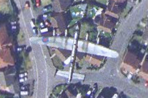
The Register
recently unearthed what is for me one of the best shots of an aircraft in flight, a genuine WWII Avro Lancaster:


and here's the kmz
TheChemist
QUOTE (dilo @ Jan 14 2006, 01:26 AM)
about Google Mars, I found this link but I do not understand what/if/when program really does... do someone has more infos?
*

I followed your link, and I am at a loss too. It is GoogleMars but it is not Google. Then it is a space exploration company ? And then it is another company who is the medium ?
And then it says register, but registration is not available yet. And then it says register at our forum. And the forum has 168 users and 16 messages total ? laugh.gif

This must be a joke .. I wonder if Google really know about it ...
jamescanvin
QUOTE (lyford @ Jan 14 2006, 06:29 AM)
THE MAC VERSION IS HERE!!!!!

Sorry, er, uh, didn't mean to shout. And just in time for the intel based macs as well.

Now if we could only get Half Life ported. blink.gif
*


Hurrah! smile.gif smile.gif smile.gif cool.gif

Thanks for the heads up!

James
ljk4-1
Google Earth v4 Released

KurzweilAI.net June 13, 2006

*************************

A new beta version of Google Earth features 3D textured buildings,
better user interface, and higher resolution images....

http://www.kurzweilai.net/email/newsRedire...ID=5628&m=25748
This is a "lo-fi" version of our main content. To view the full version with more information, formatting and images, please click here.
Invision Power Board © 2001-2024 Invision Power Services, Inc.