MARCI Images, ISIS pointers/advice/help much appreciated and desired! |

  |
MARCI Images, ISIS pointers/advice/help much appreciated and desired! |
 Aug 21 2010, 01:40 AM Aug 21 2010, 01:40 AM
Post
#16
|
|
|
Junior Member  Group: Members Posts: 50 Joined: 16-January 06 Member No.: 646 |
QUOTE (djellison @ Aug 20 2010, 05:13 PM)  Rememebr the FOV of MARCI is HUGE. The edges you're looking really out left and right from the spacecraft so whilst it's nicely map projects, you're looking through a lot more atmosphere, and I don't think that's something you can easily calibrate out and is probably what's causing the problem. What one can do, and what was done for the MOC WA images to make the nice Daily Global Maps (DGM), is to create a "flatfield" using a large number of images coadded together, say for most of a month. This produces a nice function which can remove *uniform* dust loading (i.e., longitude independent) and the opposition surge. I haven't tried it myself to remove the opposition surge or atmospheric edge effects (I try to use these edge effects to study the atmosphere), but I believe it is being done internally at MSSS to produce DGMs for internal project use. A similar effort was done using many months of images (actually more than a year of images) to provide an improvement to the ground-calibration flat fields. I read about this being applied to Clementine images, and it seemed to work well enough for the flat field improvements. |
 |
 
|
|
Aug 24 2010, 02:44 PM
Post
#17
|
||
|
Member Group: Members Posts: 293 Joined: 29-August 06 From: Columbia, MD Member No.: 1083 |
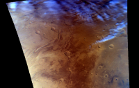
Using a MARCI swath from a later orbit (6124), I made this image of Lunae Planum. The dark albedo terrain seems to be closer to "true color" in this image vice the ones I posted last week with the blue tinge. I didn't change anything, so perhaps the MARCI team just got better with the color matching as time went along?
Attached thumbnail(s)
|
|
|
|
|
|
|
Jul 27 2012, 05:43 PM
Post
#18
|
||
|
Member Group: Members Posts: 293 Joined: 29-August 06 From: Columbia, MD Member No.: 1083 |
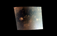
I never posted some of the other (slightly more interesting) MARCI images I did manage to produce. I abandoned this awhile ago, but am hoping to team with someone who has been paid to process MARCI imagery for more research. Anyway, here's a few more:
Attached thumbnail(s)
|
|
|
|
|
|
|
Jul 27 2012, 05:45 PM
Post
#19
|
|||
|
Member Group: Members Posts: 293 Joined: 29-August 06 From: Columbia, MD Member No.: 1083 |
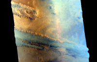
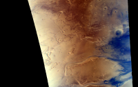
.
.
Attached thumbnail(s)
|
||
|
|
|
||
|
Jul 27 2012, 05:52 PM
Post
#20
|
|
 Senior Member Group: Moderator Posts: 3431 Joined: 11-August 04 From: USA Member No.: 98 |
Very nice. First one in that pair shows Tempe Terra and Kasei Valles; second image is just above the first one. They overlap nicely.
|
|
|
|
|
Jul 27 2012, 06:19 PM
Post
#21
|
|
|
Member Group: Members Posts: 293 Joined: 29-August 06 From: Columbia, MD Member No.: 1083 |
Yes, I split a larger image into two pieces. Combined, they represent about 1/5th (if memory serves) of a single pole-to-pole swath of the 12 MARCI takes every day.
|
|
|
|
|
Dec 26 2020, 08:35 PM
Post
#22
|
|
|
Member Group: Members Posts: 306 Joined: 4-October 14 Member No.: 7273 |
I've decided to take up working with MARCI images, given that it's a pretty sizeable dataset with a lot of goodies in it. I wanted to use it to render some overflight videos of the Martian surface, maybe one day with the goal of adding in some narration or running an ISS HDEV style stream showing the Martian surface passing underneath at real-time orbital speed. For now, here's an overflight of the North Pole / Nili Fossae / Tyrrhena Terra region on March 7, 2020 at appx. 10x real-time speed.
https://youtu.be/DcVRRpqdzeo |
|
|
|
|
Mar 6 2021, 03:47 AM
Post
#23
|
|
|
Member Group: Members Posts: 306 Joined: 4-October 14 Member No.: 7273 |
Continuing to refine my process and sharpen my skills with Blender.
This particular video simulates a view out the spacecraft window so to speak, starting over the South Pole, flying over Terra Sirenum, Daedalia Planum, and Olympus Mons. https://youtu.be/Sc5eQTorIiA Nearly impossible to derive a consistent haze profile from MARCI images, considering how small it is in the original data. So I cribbed a guesstimate from some color processings of HRSC limb scans I did a while back. Not really sure how to approach adding motion to the haze profile, and the current still-image mask seems kinda static. |
|
|
|
|
Jun 1 2021, 12:51 AM
Post
#24
|
|
|
Member Group: Members Posts: 306 Joined: 4-October 14 Member No.: 7273 |
Continuing to work with MARCI data, now rendering videos at real-time orbital speed. This orbit captures some dust storms along the southern edge of Claritas Fossae, nice albedo markings in Syria Planum, a handful of the Tharsis Montes, and the northern polar cap lit by the midnight sun.
https://www.youtube.com/watch?v=koNXF6myc5Q |
|
|
|
|
Jun 1 2021, 05:09 PM
Post
#25
|
|
 Senior Member Group: Members Posts: 1089 Joined: 19-February 05 From: Close to Meudon Observatory in France Member No.: 172 |
QUOTE (jccwrt @ Jun 1 2021, 02:51 AM) Continuing to work with MARCI data, now rendering videos at real-time orbital speed. This orbit captures some dust storms along the southern edge of Claritas Fossae, nice albedo markings in Syria Planum, a handful of the Tharsis Montes, and the northern polar cap lit by the midnight sun. This is an ASTOUNDING movie ! Thanks so much Jccwrt for sharing this work with us   |
|
|
|
|
Oct 5 2021, 03:32 PM
Post
#26
|
|
|
Member Group: Members Posts: 306 Joined: 4-October 14 Member No.: 7273 |
I rendered out a new video this weekend! This one overflies eastern Hellas, Tyrrhena Terra, Syrtis Major, and the Nili Fossae regions. As a bonus it flies over Jezero the day after Perseverance's landing.
https://youtu.be/PjwY9S0uEQc By the way, if anyone else is interested in processing MARCI images I have a shell script for use with ISIS3 that helps speed things up significantly. https://github.com/AsterAphelion/marci-parallel |
|
|
|
|
Oct 6 2021, 07:21 AM
Post
#27
|
|
|
Senior Member Group: Members Posts: 1089 Joined: 19-February 05 From: Close to Meudon Observatory in France Member No.: 172 |
QUOTE (jccwrt @ Oct 5 2021, 05:32 PM) I rendered out a new video this weekend! This one overflies eastern Hellas, Tyrrhena Terra, Syrtis Major, and the Nili Fossae regions. As a bonus it flies over Jezero the day after Perseverance's landing. By the way, if anyone else is interested in processing MARCI images I have a shell script for use with ISIS3 that helps speed things up significantly. What a nice video ! Thanks so much Jccwrt
|
|
|
|
|

|
Lo-Fi Version | Time is now: 19th October 2024 - 03:03 PM |
|
RULES AND GUIDELINES Please read the Forum Rules and Guidelines before posting. IMAGE COPYRIGHT |
OPINIONS AND MODERATION Opinions expressed on UnmannedSpaceflight.com are those of the individual posters and do not necessarily reflect the opinions of UnmannedSpaceflight.com or The Planetary Society. The all-volunteer UnmannedSpaceflight.com moderation team is wholly independent of The Planetary Society. The Planetary Society has no influence over decisions made by the UnmannedSpaceflight.com moderators. |
SUPPORT THE FORUM Unmannedspaceflight.com is funded by the Planetary Society. Please consider supporting our work and many other projects by donating to the Society or becoming a member. |
|