A Tribute to Opportunity and her Epic Journey, Flying Over Endeavour Crater |

  |
A Tribute to Opportunity and her Epic Journey, Flying Over Endeavour Crater |
 Aug 27 2011, 04:21 PM Aug 27 2011, 04:21 PM
Post
#1
|
|
|
Member  Group: Members Posts: 713 Joined: 30-March 05 Member No.: 223 |
Although this is still a work in progress, I would like to share with you a preview of a new project I'm working on:
 Flying Over Endeavour Crater - A Tribute to Opportunity and her Epic Journey Flying Over Endeavour Crater - A Tribute to Opportunity and her Epic Journey (The video is best viewed in HD resolution (720p), fullscreen and volume turned up for the background music. Click here for a (still experimental) excerpt as anaglyph (view in HD if possible) Here is some background info for the technically interested: The whole DEM consists of about 3 billions of triangles, modelling Endeavour's west rim at full HiRISE resolution of 25cm/pixel. Unlike the standard method (of draping hi-res 2D imagery over a lower-res 3D DEM), the new technique provides real 3D geometry down to the highest resolution level (i.e. 0.25 m/pixel for HiRISE). This results in a more realistic visualization because each single pixel contributes genuine 3D information - as you can see for example in the low sun images where each pixel is, in principle, capable of casting its own tiny shadow. Rendering this kind of DEMs has been a real challange, though. At 0.25 m post spacing, the models are about 16 times larger than the already huge standard HiRISE DEMs at 1 m/pixel. So together with the mosaics of several full-res CTX frames ( that I'm merging the DEMs with for context ) this results in DEMs of several billions of triangles. Unfortunately this seems to be too much to render with conventional 3D programs such as 3ds-max that are usually limited to some dozens of millions of polygons, but can't readily handle several billions. This is why I decided to write a specialized gigapixel-ready terrain visualization software with a raytracing kernel for realistic soft shadows and global illumination. As this is a rather time consuming work, it is not finished yet (still missing color support and the movie processing chain is still too slow for producing longer flyovers ... ) Hardware is another limiting factor (currently I'm running out of RAM on 24 GB  ... but the new gear (48 Gigs + 12 cores) is already on the christmas wishlist... ... but the new gear (48 Gigs + 12 cores) is already on the christmas wishlist... Nevertheless the first results look promising so I thougt I'd share some impressions with the UMSF community  |
 |
 
|
|
Aug 27 2011, 04:39 PM
Post
#2
|
|
 Senior Member Group: Moderator Posts: 3431 Joined: 11-August 04 From: USA Member No.: 98 |
Astonishing!
|
|
|
|
|
Aug 27 2011, 04:49 PM
Post
#3
|
|
 Senior Member Group: Members Posts: 3648 Joined: 1-October 05 From: Croatia Member No.: 523 |
Spectacular!
-------------------- |
|
|
|
|
Aug 27 2011, 05:13 PM
Post
#4
|
|
 Member Group: Members Posts: 399 Joined: 28-August 07 From: San Francisco Member No.: 3511 |
"Epic" indeed!
-------------------- 'She drove until the wheels fell off...'
|
|
|
|
|
Aug 27 2011, 05:13 PM
Post
#5
|
|
|
Junior Member Group: Members Posts: 24 Joined: 11-February 07 From: College Station, TX Member No.: 1709 |
Wow! That is truly awesome and inspiring!
I don't know if you're taking requests, but it would be really neat to see a model of Opportunity at some spot in her trek and do a "fly over". |
|
|
|
|
Aug 27 2011, 09:35 PM
Post
#6
|
|
|
Member Group: Members Posts: 194 Joined: 3-January 10 Member No.: 5156 |
Absolute fascinating and awesome, Nirgal!
Thanks for this views and still waiting for more of them! -------------------- Need more input ...
|
|
|
|
|
Aug 27 2011, 10:34 PM
Post
#7
|
|
 Special Cookie Group: Members Posts: 2168 Joined: 6-April 05 From: Sintra | Portugal Member No.: 228 |
in good plain portuguese...f***-**!!!
-------------------- "Ride, boldly ride," The shade replied, "If you seek for Eldorado!"
Edgar Alan Poe |
|
|
|
| Guest_Oersted_* |
Aug 27 2011, 10:50 PM
Post
#8
|
|
Guests |
Ah, I thought that would be c******! Ustrax...
- Anyway, I agree with the sentiment!- Do you plan to make a version without vertical exaggeration, Nirgal? |
|
|
|
|
Aug 27 2011, 11:18 PM
Post
#9
|
|
|
Member Group: Members Posts: 128 Joined: 10-December 06 From: Atlanta Member No.: 1472 |
Excellent job! Do you use a flat plane or a sphere (to represent Mars curvature) as the base?
|
|
|
|
|
Aug 28 2011, 03:59 AM
Post
#10
|
|
 Member Group: Members Posts: 404 Joined: 5-January 10 Member No.: 5161 |
Some of the best flyovers of Mars I've seen yet. Please keep this up.
|
|
|
|
|
Aug 28 2011, 04:01 AM
Post
#11
|
|
 Senior Member Group: Members Posts: 2228 Joined: 1-December 04 From: Marble Falls, Texas, USA Member No.: 116 |
Oh, wow! I am speechless.
-------------------- ...Tom
I'm not a Space Fan, I'm a Space Exploration Enthusiast. |
|
|
|
|
Aug 28 2011, 09:42 AM
Post
#12
|
|
|
Newbie Group: Members Posts: 8 Joined: 17-October 10 Member No.: 5494 |
Beautiful!!!
But i think the vertical scale is exeggerated -I see this on the sand dunes-end of the animation. It was made intentionally? |
|
|
|
|
Aug 28 2011, 11:34 AM
Post
#13
|
||
|
Member Group: Members Posts: 713 Joined: 30-March 05 Member No.: 223 |
Thank you very much for the nice comments on my work. glad you like it !
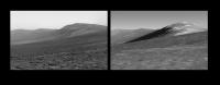
As there were questions about the vertical scale of the model I would like to point out there is no intentional vertical exaggeration of the geometry as you can see in this image comparing a "ground truth" photograph taken by the rover as of Sol 2679 on the left hand with a simulated view of the 3D model from approximately the same position and viewing angle (the shadowed slope in the right image is due to a lower simulated sun angle)
It is true that in my renderings I always try to emphasize & accentuate the topography for reasons of viewing aesthetics, but this is largely due to my using very low sun illumination angles just by simulating late-evening conditions with long shadows (this is just the same as landscape photograpers here on earth would do in order to accentuate the shape of dunes and mountains) In addition to that I tend to use settings of my simulated camera and darkroom that result in contrast enhancement and lens-induced geometric distortions (again the same as landscape phoptographers would do here on earth as well :-) That being said: although the large scale topography of the model is exactly registered to official MOLA and HRSC DEMs there remains uncertainty in the small-scale variations of the surface model as with any single-image based 3D reconstruction method namely in the presence of albedo variations. Without albedo variations (i.e. fully dust- or ice- coverd areas) I found the mean reconstruction errors in my experiments to be less than ten precent compared to ground-truth DEMs but the error can be larger in presence of large albedo variations. Fortunately, the single-image method complements nicely with stereo-based methods that are immune to albedo variations (but provide only a fraction of the resolution and have troubles in texture-less areas). Although maximum scientific accuracy has never been the main goal of my work (that is intended for porposes of visualization and aesthetics only - in the sense of "Martian Landscape Photography"  I do plan to further improve the overall accuracy of my models in the future by incorporating more stereo-derived base DEMs. I'm especially looking forward to the official Endeavour HiRISE DTM that I think will be published in the near future and that I expect to provide a very accurate base-DEM for that area I do plan to further improve the overall accuracy of my models in the future by incorporating more stereo-derived base DEMs. I'm especially looking forward to the official Endeavour HiRISE DTM that I think will be published in the near future and that I expect to provide a very accurate base-DEM for that area
|
|
|
|
|
|
|
Aug 28 2011, 01:12 PM
Post
#14
|
|
 Interplanetary Dumpster Diver Group: Admin Posts: 4404 Joined: 17-February 04 From: Powell, TN Member No.: 33 |
Simply amazing!
-------------------- |
|
|
|
|
Aug 28 2011, 02:30 PM
Post
#15
|
|
 The Poet Dude Group: Moderator Posts: 5551 Joined: 15-March 04 From: Kendal, Cumbria, UK Member No.: 60 |
Stunning, just... stunning...

-------------------- |
|
|
|
|

|
Lo-Fi Version | Time is now: 28th September 2024 - 01:45 PM |
|
RULES AND GUIDELINES Please read the Forum Rules and Guidelines before posting. IMAGE COPYRIGHT |
OPINIONS AND MODERATION Opinions expressed on UnmannedSpaceflight.com are those of the individual posters and do not necessarily reflect the opinions of UnmannedSpaceflight.com or The Planetary Society. The all-volunteer UnmannedSpaceflight.com moderation team is wholly independent of The Planetary Society. The Planetary Society has no influence over decisions made by the UnmannedSpaceflight.com moderators. |
SUPPORT THE FORUM Unmannedspaceflight.com is funded by the Planetary Society. Please consider supporting our work and many other projects by donating to the Society or becoming a member. |
|