Titan's big rainstorms |

  |
Titan's big rainstorms |
 May 6 2015, 05:59 PM May 6 2015, 05:59 PM
Post
#1
|
|
|
Senior Member  Group: Members Posts: 3516 Joined: 4-November 05 From: North Wales Member No.: 542 |
Here is an interesting-sounding paper getting into the nitty gritty of how big convective storm systems on Titan might work and look. I particularly recommend the animations of various storm scenarios in the Supporting Materials. Factor out the different vertical and horizontal scales and you might almost be standing there with your umbrella on the point of collapse - or blown inside out.
https://secure.onlinelibrary.wiley.com/secu...MePresent=false |
 |
 
|
|
May 6 2015, 10:45 PM
Post
#2
|
|
 Senior Member Group: Members Posts: 1670 Joined: 5-March 05 From: Boulder, CO Member No.: 184 |
Nice animations of the storms. I wonder how they would look using 3D volume rendering with realistic lighting.
-------------------- Steve [ my home page and planetary maps page ]
|
|
|
|
|
May 9 2015, 03:13 PM
Post
#3
|
|
|
Member Group: Members Posts: 710 Joined: 1-April 08 From: Minnesota ! Member No.: 4081 |
Very interesting paper indeed! Really BIG equatorial storms on Titan are discussed in another recent (online) paper in Nature geoscience (Nature Geoscience 8, 362–366 (2015) doi:10.1038/ngeo2406). http://www.space.com/29090-titan-methane-s...sand-dunes.html. , concluding such storms may be responsible for sculpting the apparent west to east migration of Titan’s equatorial dunes. As I understand it the storms height reach altitudes where stronger west to east winds exist producing a downdraft gust front at the surface going west to east up to 10 times the velocity of Titan’s usual east to west surface winds.
I may have missed it but I would have liked to seen the authors of these papers model other features of the really big storms like the “arrow storm” in 2010 (with its 1,200 kilometers in length east-to-west and wings that trailed off to the northwest and southwest each 1,500 kilometers long) or the April 2008 storm described in the Schaller et al paper http://www.nature.com/nature/journal/v460/...ature08193.html both of which created clouds far removed from their propagating centers (?due to Rossby wave effects?) |
|
|
|
|
May 9 2015, 07:12 PM
Post
#4
|
|
|
Senior Member Group: Members Posts: 3516 Joined: 4-November 05 From: North Wales Member No.: 542 |
I remember reading somewhere recently (though annoyingly can't find it now) that convective storms on Titan can be powerful enough to punch straight through the tropopause and into the stratosphere. This is also inplicitly stated in the dunes paper you linked to but that's not the source I'm thinking of. A storm system rising through at least three distinct layers of atmosphere each with it's own wind direction could I suppose produce a shape such as the 'arrow storm'. I would love to see altitude estimates for the different wings of that arrow but I don't know if such estimates can be teased out of the available data. I have been giving extra thought recently to the possible appearance of chaotic skyscapes following a Titan rainstorm as I hope to incorporate some hints of this in a landscape I'm working on. In the meantime here is a picture of wind gusts over Everest punching vertically into Earth's stratosphere:
http://www.google.co.uk/imgres?imgurl=http...ed=0CCAQMygAMAA |
|
|
|
|
May 9 2015, 07:44 PM
Post
#5
|
|
|
Member Group: Members Posts: 710 Joined: 1-April 08 From: Minnesota ! Member No.: 4081 |
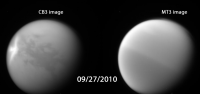
I don't know if this is telling us something real but manipulating the original 'arrow storm' CL1 CB3 and the MT3 images in Photoshop seems to suggest the northwest wing of the storm was a bit lower in altitude than the center and southwest wing and that the NS equitororial boundary was respected.
http://www.unmannedspaceflight.com/index.p...st&id=22705 |
|
|
|
|
May 9 2015, 08:22 PM
Post
#6
|
|
|
Senior Member Group: Members Posts: 3516 Joined: 4-November 05 From: North Wales Member No.: 542 |
Nice work!
I almost forgot. Arrow shapes seem to be a recurring theme. There is another smaller one dead centre here: http://www.google.co.uk/imgres?imgurl=http...ed=0CCIQMygCMAI |
|
|
|
|
May 11 2015, 06:17 PM
Post
#7
|
|||
|
Member Group: Members Posts: 710 Joined: 1-April 08 From: Minnesota ! Member No.: 4081 |
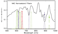
QUOTE (titanicrivers @ May 9 2015, 01:44 PM)  I don't know if this is telling us something real but manipulating the original 'arrow storm' CL1 CB3 and the MT3 images in Photoshop seems to suggest the northwest wing of the storm was a bit lower in altitude than the center and southwest wing and that the NS equitororial boundary was respected. http://www.unmannedspaceflight.com/index.p...st&id=22705 On the other hand the arrow storm wings may be of equal altitude and the seasonal NS haze particle differential obscuration of lower atmospheric and surface phenomena may well explain the fading of the NW wing of the Arrow storm. The transmission of the MT3 and CB3 filters differs substantially (see graph from http://pubs.giss.nasa.gov/docs/2004/2004_Porco_etal_1.pdf and original Cassini images) and so the Photoshop manipulation might simply be this effect.
|
||
|
|
|
||
|
Oct 13 2017, 08:19 PM
Post
#8
|
|
|
Member Group: Members Posts: 866 Joined: 15-March 05 From: Santa Cruz, CA Member No.: 196 |
interesting read on physx.org modeling suggests big apparently seasonal storms dump over a foot of 'rain' a day.. Extreme methane rainstorms appear to have a key role in shaping Titan's icy surface
|
|
|
|
|
Oct 22 2017, 05:58 PM
Post
#9
|
|
 Member Group: Members Posts: 613 Joined: 23-February 07 From: Occasionally in Columbia, MD Member No.: 1764 |
QUOTE (atomoid @ Oct 13 2017, 03:19 PM) interesting read on physx.org modeling suggests big apparently seasonal storms dump over a foot of 'rain' a day.. Extreme methane rainstorms appear to have a key role in shaping Titan's icy surface Yes, this qualitatively is quite an old suggestion (pre-Cassini) and follows simply from the moisture-capacity of the atmosphere (I like to say 'Titan is to the hydrological cycle what Venus is to the greenhouse effect - a terrestrial process taken to an instructive extreme' : as our atmosphere warms and can hold more moisture, basically like putting a larger capacitor in a relaxation oscillator circuit - we will get heavier storms separated by longer droughts) What is interesting about the new work, using a global circulation model, is that it shows differences in precipitation character at different latitudes, with the most extreme storms at midlatitudes where Cassini has observed alluvial fans. |
|
|
|
|
Mar 20 2018, 09:32 PM
Post
#10
|
|
 Senior Member Group: Members Posts: 1887 Joined: 20-November 04 From: Iowa Member No.: 110 |
|
|
|
|
|

|
Lo-Fi Version | Time is now: 19th October 2024 - 07:29 PM |
|
RULES AND GUIDELINES Please read the Forum Rules and Guidelines before posting. IMAGE COPYRIGHT |
OPINIONS AND MODERATION Opinions expressed on UnmannedSpaceflight.com are those of the individual posters and do not necessarily reflect the opinions of UnmannedSpaceflight.com or The Planetary Society. The all-volunteer UnmannedSpaceflight.com moderation team is wholly independent of The Planetary Society. The Planetary Society has no influence over decisions made by the UnmannedSpaceflight.com moderators. |
SUPPORT THE FORUM Unmannedspaceflight.com is funded by the Planetary Society. Please consider supporting our work and many other projects by donating to the Society or becoming a member. |
|