Phoenix parachute, changes in HiRISE images |

  |
Phoenix parachute, changes in HiRISE images |
 May 27 2014, 03:30 PM May 27 2014, 03:30 PM
Post
#1
|
||
|
Solar System Cartographer  Group: Members Posts: 10251 Joined: 5-April 05 From: Canada Member No.: 227 |
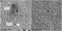
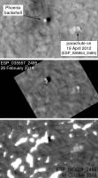
Big news from Phoenix-land.
The latest released image of the landing site shows a big change in the parachute since landing. There are lots of images of this site, so a time-series set could be very interesting. Here's a comparison - the left side is a figure from my future book, showing the parachute just after landing. the right side is the newest image taken in February 2014. The parachute has clearly moved very considerably - surely there is no other possible explanation for this? And I wonder if it didn't pull the backshell enough to tip it over, because that looks different as well. I will search back in time to try to find when this happened, but I probably can't put much time into it. Phil
-------------------- ... because the Solar System ain't gonna map itself.
Also to be found posting similar content on https://mastodon.social/@PhilStooke Maps for download (free PDF: https://upload.wikimedia.org/wikipedia/comm...Cartography.pdf NOTE: everything created by me which I post on UMSF is considered to be in the public domain (NOT CC, public domain) |
|
 |
 
|
|
|
May 27 2014, 03:41 PM
Post
#2
|
|
|
Founder Group: Chairman Posts: 14444 Joined: 8-February 04 Member No.: 1 |
NICE FIND (especially as the HiRISE team didn't use the word Phoenix in the observation title! ) As some of you know - watching parachutes in HiRISE is something of a personal obsession. Spirit's flapped around once and hasn't moved since. Still waiting for follow up images with Opportunity. But I hadn't thought to look at the Phoenix chute. Now on my to-do list!
|
|
|
|
|
May 27 2014, 07:41 PM
Post
#3
|
|
|
Solar System Cartographer Group: Members Posts: 10251 Joined: 5-April 05 From: Canada Member No.: 227 |
Right... HiRISE team did not use Phoenix in the title. If you only search on Phoenix you won't find anything like all the images. I prefer to use this site:
http://themis.asu.edu/maps - choose HiRISE, zoom in on the area of interest, get image info, and it will identify LOTS of images. When I choose one off that list I just copy the image number and paste it into the address bar on the HiRISE site to get to that specific image. Phil -------------------- ... because the Solar System ain't gonna map itself.
Also to be found posting similar content on https://mastodon.social/@PhilStooke Maps for download (free PDF: https://upload.wikimedia.org/wikipedia/comm...Cartography.pdf NOTE: everything created by me which I post on UMSF is considered to be in the public domain (NOT CC, public domain) |
|
|
|
|
May 27 2014, 08:46 PM
Post
#4
|
|
|
Solar System Cartographer Group: Members Posts: 10251 Joined: 5-April 05 From: Canada Member No.: 227 |
A quick look suggests to me that the change happened between June 2010 and April 2012.
Phil -------------------- ... because the Solar System ain't gonna map itself.
Also to be found posting similar content on https://mastodon.social/@PhilStooke Maps for download (free PDF: https://upload.wikimedia.org/wikipedia/comm...Cartography.pdf NOTE: everything created by me which I post on UMSF is considered to be in the public domain (NOT CC, public domain) |
|
|
|
|
May 27 2014, 09:03 PM
Post
#5
|
||
|
Founder Group: Chairman Posts: 14444 Joined: 8-February 04 Member No.: 1 |
Previously I'd only been able to track it during '08 when there were subtle changes ( bits folding over etc ) twice in October '08 and once between then and December.
|
|
|
|
|
|
|
May 19 2016, 06:15 AM
Post
#6
|
||
|
Solar System Cartographer Group: Members Posts: 10251 Joined: 5-April 05 From: Canada Member No.: 227 |
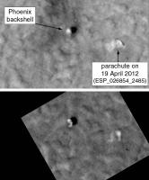
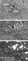
Here's a 2014 image of the Phoenix parachute, with a comparison to the 2012 appearance above it. There is a bit more movement but not a big change. This is rotated so north is at the top. If you save the file the HiRISE image number is in the filename.
Phil
-------------------- ... because the Solar System ain't gonna map itself.
Also to be found posting similar content on https://mastodon.social/@PhilStooke Maps for download (free PDF: https://upload.wikimedia.org/wikipedia/comm...Cartography.pdf NOTE: everything created by me which I post on UMSF is considered to be in the public domain (NOT CC, public domain) |
|
|
|
|
|
|
May 19 2016, 06:18 AM
Post
#7
|
||
|
Solar System Cartographer Group: Members Posts: 10251 Joined: 5-April 05 From: Canada Member No.: 227 |
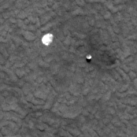
Also - though it's not the parachute, it doesn't seem useful to resurrect another old thread - here is the 2014 image of the lander, compared with its brand new appearance. I interpret it to mean that the lander body is still standing but both solar panels have broken off - they don't cast shadows.
Phil
-------------------- ... because the Solar System ain't gonna map itself.
Also to be found posting similar content on https://mastodon.social/@PhilStooke Maps for download (free PDF: https://upload.wikimedia.org/wikipedia/comm...Cartography.pdf NOTE: everything created by me which I post on UMSF is considered to be in the public domain (NOT CC, public domain) |
|
|
|
|
|
|
May 19 2016, 06:05 PM
Post
#8
|
|
 Administrator Group: Admin Posts: 5172 Joined: 4-August 05 From: Pasadena, CA, USA, Earth Member No.: 454 |
Poor Phoenix

-------------------- My website - My Patreon - @elakdawalla on Twitter - Please support unmannedspaceflight.com by donating here.
|
|
|
|
|
May 20 2016, 06:08 PM
Post
#9
|
||
|
Solar System Cartographer Group: Members Posts: 10251 Joined: 5-April 05 From: Canada Member No.: 227 |
It took a while to find Phoenix in the most recent image, but here is a composite showing the parachute only 6 months ago, with the other two images as well.
Phil
-------------------- ... because the Solar System ain't gonna map itself.
Also to be found posting similar content on https://mastodon.social/@PhilStooke Maps for download (free PDF: https://upload.wikimedia.org/wikipedia/comm...Cartography.pdf NOTE: everything created by me which I post on UMSF is considered to be in the public domain (NOT CC, public domain) |
|
|
|
|
|
|
May 20 2016, 06:17 PM
Post
#10
|
||
|
Solar System Cartographer Group: Members Posts: 10251 Joined: 5-April 05 From: Canada Member No.: 227 |
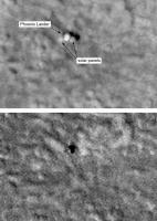
And the lander with the latest view.
Phil
-------------------- ... because the Solar System ain't gonna map itself.
Also to be found posting similar content on https://mastodon.social/@PhilStooke Maps for download (free PDF: https://upload.wikimedia.org/wikipedia/comm...Cartography.pdf NOTE: everything created by me which I post on UMSF is considered to be in the public domain (NOT CC, public domain) |
|
|
|
|
|
|
May 20 2016, 07:24 PM
Post
#11
|
|
|
Merciless Robot Group: Admin Posts: 8789 Joined: 8-December 05 From: Los Angeles Member No.: 602 |
Wow. Fascinating to watch this over the seasons. I wonder how long it will take for the hardware to become completely indistinguishable from the surroundings.
-------------------- A few will take this knowledge and use this power of a dream realized as a force for change, an impetus for further discovery to make less ancient dreams real.
|
|
|
|
|

|
Lo-Fi Version | Time is now: 19th October 2024 - 08:22 PM |
|
RULES AND GUIDELINES Please read the Forum Rules and Guidelines before posting. IMAGE COPYRIGHT |
OPINIONS AND MODERATION Opinions expressed on UnmannedSpaceflight.com are those of the individual posters and do not necessarily reflect the opinions of UnmannedSpaceflight.com or The Planetary Society. The all-volunteer UnmannedSpaceflight.com moderation team is wholly independent of The Planetary Society. The Planetary Society has no influence over decisions made by the UnmannedSpaceflight.com moderators. |
SUPPORT THE FORUM Unmannedspaceflight.com is funded by the Planetary Society. Please consider supporting our work and many other projects by donating to the Society or becoming a member. |
|