Asteroid approach, Science operations begin! |

  |
Asteroid approach, Science operations begin! |
| Guest_mcmcmc_* |
 Nov 1 2018, 04:21 PM Nov 1 2018, 04:21 PM
Post
#16
|
|
Guests |
QUOTE (mcaplinger @ Oct 31 2018, 09:44 PM)  They are files that capture the position and orientation of spacecraft and solar system bodies, used for mission planning and data analysis. https://naif.jpl.nasa.gov/naif/aboutspice.html If NASA Horizons does what you want, then by all means use it. I'm not certain how frequently it's updated, however. It's not clear to me how these data about spacecrafts are produced; are they recorded data up to current date and calculated data from now on? i.e. are they daily updated? or just calculated from mission schedules? OSIRIS data clearly show the trajectory correction maneuvers occurred during last months, but Hayabusa data show almost constant distance 7000m from Ryugu for same period, which is not true because Hayabusa actually passed from 20.000 to 20m and the other way round several times. |
 |
 
|
|
Nov 1 2018, 05:34 PM
Post
#17
|
|
|
Founder  Group: Chairman Posts: 14434 Joined: 8-February 04 Member No.: 1 |
QUOTE (mcmcmc @ Nov 1 2018, 08:21 AM) It's not clear to me how these data about spacecrafts are produced; are they recorded data up to current date and calculated data from now on? i.e. are they daily updated? or just calculated from mission schedules? Yes. All of the above. Sometimes they are reconstructed. Sometimes they are predicted. Sometimes updated very regularly. Sometimes not. Metadata is usually included to explain the source of the data used. |
|
|
|
|
Nov 2 2018, 08:07 PM
Post
#18
|
||
|
Solar System Cartographer Group: Members Posts: 10231 Joined: 5-April 05 From: Canada Member No.: 227 |
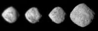
An approach GIF was just released - these are the 4 best frames, rescaled. The surface is becoming clearer.
Phil
-------------------- ... because the Solar System ain't gonna map itself.
Also to be found posting similar content on https://mastodon.social/@PhilStooke Maps for download (free PDF: https://upload.wikimedia.org/wikipedia/comm...Cartography.pdf NOTE: everything created by me which I post on UMSF is considered to be in the public domain (NOT CC, public domain) |
|
|
|
|
|
|
Nov 6 2018, 01:22 AM
Post
#19
|
|
 Senior Member Group: Members Posts: 1452 Joined: 26-July 08 Member No.: 4270 |
-------------------- -- Hungry4info (Sirius_Alpha)
|
|
|
|
|
Nov 6 2018, 03:46 AM
Post
#20
|
|
|
Senior Member Group: Members Posts: 2106 Joined: 13-February 10 From: Ontario Member No.: 5221 |
Interesting dark patches in the southern hemisphere on the right image, and what might be a crater on the far right limb?
EDIT: rotation movie out! I'll leave it to the experts.... https://www.asteroidmission.org/bennu-rotation_20181102/ |
|
|
|
|
Nov 6 2018, 09:09 PM
Post
#21
|
|
|
Senior Member Group: Members Posts: 1075 Joined: 21-September 07 From: Québec, Canada Member No.: 3908 |
|
|
|
|
|
Nov 7 2018, 12:10 AM
Post
#22
|
|
|
Solar System Cartographer Group: Members Posts: 10231 Joined: 5-April 05 From: Canada Member No.: 227 |
Beautiful! That should be enough for a preliminary shape model and map.
Phil -------------------- ... because the Solar System ain't gonna map itself.
Also to be found posting similar content on https://mastodon.social/@PhilStooke Maps for download (free PDF: https://upload.wikimedia.org/wikipedia/comm...Cartography.pdf NOTE: everything created by me which I post on UMSF is considered to be in the public domain (NOT CC, public domain) |
|
|
|
| Guest_mcmcmc_* |
Nov 7 2018, 11:13 AM
Post
#23
|
|
Guests |
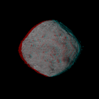
QUOTE (Phil Stooke @ Nov 7 2018, 01:10 AM) Beautiful! That should be enough for a preliminary shape model and map. Phil Shape model (just look, don't touch :-( ): https://twitter.com/3Dmattias/status/1059936642612502529 |
|
|
|
|
Nov 8 2018, 06:05 AM
Post
#24
|
||
 Member Group: Members Posts: 404 Joined: 5-January 10 Member No.: 5161 |
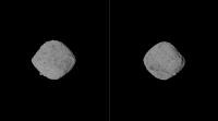
Here's a quickly rotating GIF in 3D of it, with contrast boost. Will post a slower next.
|
|
|
|
|
|
|
Nov 8 2018, 06:11 AM
Post
#25
|
||
|
Member Group: Members Posts: 404 Joined: 5-January 10 Member No.: 5161 |
This version spins much slower, at 3 second intervals, less jarring on the eyes:
|
|
|
|
|
|
|
Nov 8 2018, 07:33 AM
Post
#26
|
||
|
Solar System Cartographer Group: Members Posts: 10231 Joined: 5-April 05 From: Canada Member No.: 227 |
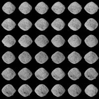
Nice! And another way of presenting the data in the animation, a set of frames. The last one is a repeat of the first one. A bit of a contrast stretch was applied.
Phil
-------------------- ... because the Solar System ain't gonna map itself.
Also to be found posting similar content on https://mastodon.social/@PhilStooke Maps for download (free PDF: https://upload.wikimedia.org/wikipedia/comm...Cartography.pdf NOTE: everything created by me which I post on UMSF is considered to be in the public domain (NOT CC, public domain) |
|
|
|
|
|
|
Nov 9 2018, 01:17 PM
Post
#27
|
|
|
Junior Member Group: Members Posts: 80 Joined: 18-October 15 From: Russia Member No.: 7822 |
Asteroid Bennu Rotation (3D animation)
 
-------------------- |
|
|
|
| Guest_mcmcmc_* |
Nov 12 2018, 09:15 PM
Post
#28
|
|
Guests |
Interactive video:
http://win98.altervista.org/space/explorat...r/rotation.html (allow several seconds until all 250 frames load). Updated monitoring page: http://win98.altervista.org/space/exploration |
|
|
|
|
Nov 23 2018, 07:53 PM
Post
#29
|
|
|
Senior Member Group: Members Posts: 1075 Joined: 21-September 07 From: Québec, Canada Member No.: 3908 |
|
|
|
|
|
Nov 24 2018, 09:07 AM
Post
#30
|
||
|
Junior Member Group: Members Posts: 22 Joined: 13-November 15 Member No.: 7840 |
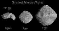
Bennu is really very small compared to Ryugu, it's as big as Itokawa ... but why doesn't Itokwa have the same shape?
|
|
|
|
|
|
|

|
Lo-Fi Version | Time is now: 28th September 2024 - 11:50 PM |
|
RULES AND GUIDELINES Please read the Forum Rules and Guidelines before posting. IMAGE COPYRIGHT |
OPINIONS AND MODERATION Opinions expressed on UnmannedSpaceflight.com are those of the individual posters and do not necessarily reflect the opinions of UnmannedSpaceflight.com or The Planetary Society. The all-volunteer UnmannedSpaceflight.com moderation team is wholly independent of The Planetary Society. The Planetary Society has no influence over decisions made by the UnmannedSpaceflight.com moderators. |
SUPPORT THE FORUM Unmannedspaceflight.com is funded by the Planetary Society. Please consider supporting our work and many other projects by donating to the Society or becoming a member. |
|