Danuri: Korea's first lunar orbiter |

  |
Danuri: Korea's first lunar orbiter |
 Jul 26 2022, 09:19 PM Jul 26 2022, 09:19 PM
Post
#1
|
|
|
Solar System Cartographer  Group: Members Posts: 10251 Joined: 5-April 05 From: Canada Member No.: 227 |
https://www.kari.re.kr/eng/sub03_07_01.do
The link is to the Korean Space Agency's page on Danuri, the nation's first lunar orbiter. It will launch from the US in early August and orbit the Moon for a year. Of particular note is he inclusion of Shadowcam, a US payload modified from the LRO NAC instrument to image in polar shadows. I think I have seen it is 200 times more sensitive that NAC. We can hope for a lot of interesting images of polar areas. Work on a followup lander is in progress but may be slow. Phil -------------------- ... because the Solar System ain't gonna map itself.
Also to be found posting similar content on https://mastodon.social/@PhilStooke Maps for download (free PDF: https://upload.wikimedia.org/wikipedia/comm...Cartography.pdf NOTE: everything created by me which I post on UMSF is considered to be in the public domain (NOT CC, public domain) |
 |
 
|
|
Jul 26 2022, 09:31 PM
Post
#2
|
|
|
Senior Member Group: Members Posts: 2547 Joined: 13-September 05 Member No.: 497 |
QUOTE (Phil Stooke @ Jul 26 2022, 01:19 PM)  I think I have seen it is 200 times more sensitive that NAC. Something like that; larger pixels (12 micron instead of 7), 32 TDI stages, and a higher QE sensor. It was a big pain to test compared to NAC because we had to use strong ND filters to image any normal scene. More info at http://shadowcam.sese.asu.edu/ -------------------- Disclaimer: This post is based on public information only. Any opinions are my own.
|
|
|
|
|
Jul 26 2022, 10:03 PM
Post
#3
|
|
|
Solar System Cartographer Group: Members Posts: 10251 Joined: 5-April 05 From: Canada Member No.: 227 |
Thanks, Mike.
Thinking about its operation... an area near a PSR but not in it will often be shadowed but sometimes illuminated. When it is illuminated NAC can see it perfectly well, but it will have very pronounced shadows which might complicate mission planning (e.g. a rover traverse into the PSR). There might be some occasions where an area like that could be imaged while in shadow, with the more diffuse reflected light softening the shadows enough to be helpful. I look forward to seeing the images. Phil -------------------- ... because the Solar System ain't gonna map itself.
Also to be found posting similar content on https://mastodon.social/@PhilStooke Maps for download (free PDF: https://upload.wikimedia.org/wikipedia/comm...Cartography.pdf NOTE: everything created by me which I post on UMSF is considered to be in the public domain (NOT CC, public domain) |
|
|
|
|
Jul 26 2022, 10:10 PM
Post
#4
|
|
|
Senior Member Group: Members Posts: 2547 Joined: 13-September 05 Member No.: 497 |
QUOTE (Phil Stooke @ Jul 26 2022, 02:03 PM) I look forward to seeing the images. As do we! Keep in mind that while the launch is just a week away, it takes KPLO quite a while to get to the Moon; mapping won't start until sometime in December, I think. See https://directory.eoportal.org/web/eoportal...missions/k/kplo -------------------- Disclaimer: This post is based on public information only. Any opinions are my own.
|
|
|
|
|
Jul 26 2022, 11:54 PM
Post
#5
|
|
|
Senior Member Group: Members Posts: 2547 Joined: 13-September 05 Member No.: 497 |
BTW, in case this has occurred to anyone -- Shadowcam is not sensitive enough to see by Earthlight, but it's too sensitive to image anything illuminated by the Sun without saturating. So it can really only image shadowed regions slightly illuminated by surrounding lit topography. We tried to make it as insensitive to stray light as we could, but mixes of shadow and sunlight may cause problems -- we'll just have to see.
-------------------- Disclaimer: This post is based on public information only. Any opinions are my own.
|
|
|
|
|
Sep 1 2022, 07:42 AM
Post
#6
|
|
|
Solar System Cartographer Group: Members Posts: 10251 Joined: 5-April 05 From: Canada Member No.: 227 |
-------------------- ... because the Solar System ain't gonna map itself.
Also to be found posting similar content on https://mastodon.social/@PhilStooke Maps for download (free PDF: https://upload.wikimedia.org/wikipedia/comm...Cartography.pdf NOTE: everything created by me which I post on UMSF is considered to be in the public domain (NOT CC, public domain) |
|
|
|
|
Sep 1 2022, 01:44 PM
Post
#7
|
||
|
Junior Member Group: Members Posts: 38 Joined: 7-October 20 Member No.: 8895 |
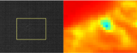
QUOTE (mcaplinger @ Jul 27 2022, 05:24 AM) BTW, in case this has occurred to anyone -- Shadowcam is not sensitive enough to see by Earthlight, but it's too sensitive to image anything illuminated by the Sun without saturating. So it can really only image shadowed regions slightly illuminated by surrounding lit topography. We tried to make it as insensitive to stray light as we could, but mixes of shadow and sunlight may cause problems -- we'll just have to see. I am waiting to see images from shadow cam as it gives us more insight into areas like these from NAC near the Shackleton (This is near the landing area of Artemis near the connecting ridge). Max temperature in Summer is around 120K so most probably it might be ice!
Attached thumbnail(s)
|
|
|
|
|
|
|
Oct 2 2022, 11:22 PM
Post
#8
|
|
|
Solar System Cartographer Group: Members Posts: 10251 Joined: 5-April 05 From: Canada Member No.: 227 |
Round about now Danuri is at its most distant from Earth, 1.55 million km, out near Sun-Earth L1. It will now begin to fall in towards Earth and encounter the Moon in December.
Phil -------------------- ... because the Solar System ain't gonna map itself.
Also to be found posting similar content on https://mastodon.social/@PhilStooke Maps for download (free PDF: https://upload.wikimedia.org/wikipedia/comm...Cartography.pdf NOTE: everything created by me which I post on UMSF is considered to be in the public domain (NOT CC, public domain) |
|
|
|
|
Nov 9 2022, 08:16 PM
Post
#9
|
||
|
Solar System Cartographer Group: Members Posts: 10251 Joined: 5-April 05 From: Canada Member No.: 227 |
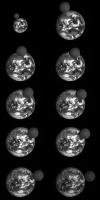
A transit (passing over Korea) on 24 September. These are frames from a video on the mission website.
Phil
-------------------- ... because the Solar System ain't gonna map itself.
Also to be found posting similar content on https://mastodon.social/@PhilStooke Maps for download (free PDF: https://upload.wikimedia.org/wikipedia/comm...Cartography.pdf NOTE: everything created by me which I post on UMSF is considered to be in the public domain (NOT CC, public domain) |
|
|
|
|
|
|
Nov 10 2022, 12:02 AM
Post
#10
|
|
 Member Group: Members Posts: 716 Joined: 3-December 04 From: Boulder, Colorado, USA Member No.: 117 |
Sweet! Do you have a link to the original source?
John |
|
|
|
|
Nov 10 2022, 06:00 AM
Post
#11
|
|
|
Solar System Cartographer Group: Members Posts: 10251 Joined: 5-April 05 From: Canada Member No.: 227 |
I thought the link I put in the first post in this thread was to that page but I see now that it is not.
Here is the Danuri website's multimedia page: https://www.kari.re.kr/kplo/multimedia And this is that specific item: https://www.kari.re.kr/kplo/danuri/multi/mu...&searchWrd= Phil -------------------- ... because the Solar System ain't gonna map itself.
Also to be found posting similar content on https://mastodon.social/@PhilStooke Maps for download (free PDF: https://upload.wikimedia.org/wikipedia/comm...Cartography.pdf NOTE: everything created by me which I post on UMSF is considered to be in the public domain (NOT CC, public domain) |
|
|
|
|
Dec 5 2022, 08:18 AM
Post
#12
|
||
|
Solar System Cartographer Group: Members Posts: 10251 Joined: 5-April 05 From: Canada Member No.: 227 |
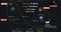
Danuri is approaching the Moon:
It will enter lunar orbit on the 17th. Phil -------------------- ... because the Solar System ain't gonna map itself.
Also to be found posting similar content on https://mastodon.social/@PhilStooke Maps for download (free PDF: https://upload.wikimedia.org/wikipedia/comm...Cartography.pdf NOTE: everything created by me which I post on UMSF is considered to be in the public domain (NOT CC, public domain) |
|
|
|
|
|
|
Dec 27 2022, 08:16 AM
Post
#13
|
|
|
Solar System Cartographer Group: Members Posts: 10251 Joined: 5-April 05 From: Canada Member No.: 227 |
Safely in orbit and getting close to its 100 km science orbit. Meanwhile, see this excellent FISO talk by Ben Bussey (now at Intuitive Machines, previously NASA).
https://fiso.spiritastro.net/telecon/Bussey_12-21-22/ Phil -------------------- ... because the Solar System ain't gonna map itself.
Also to be found posting similar content on https://mastodon.social/@PhilStooke Maps for download (free PDF: https://upload.wikimedia.org/wikipedia/comm...Cartography.pdf NOTE: everything created by me which I post on UMSF is considered to be in the public domain (NOT CC, public domain) |
|
|
|
|
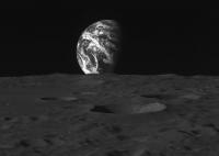
Jan 3 2023, 02:43 PM
Post
#14
|
|
 Senior Member Group: Members Posts: 1453 Joined: 26-July 08 Member No.: 4270 |
-------------------- -- Hungry4info (Sirius_Alpha)
|
|
|
|
|
Jan 3 2023, 03:10 PM
Post
#15
|
|
|
Senior Member Group: Members Posts: 2113 Joined: 13-February 10 From: Ontario Member No.: 5221 |
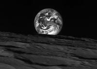
Wow! Like the old LROC Earthrise from 2014, just b/w!
|
|
|
|
|

|
Lo-Fi Version | Time is now: 19th October 2024 - 08:15 PM |
|
RULES AND GUIDELINES Please read the Forum Rules and Guidelines before posting. IMAGE COPYRIGHT |
OPINIONS AND MODERATION Opinions expressed on UnmannedSpaceflight.com are those of the individual posters and do not necessarily reflect the opinions of UnmannedSpaceflight.com or The Planetary Society. The all-volunteer UnmannedSpaceflight.com moderation team is wholly independent of The Planetary Society. The Planetary Society has no influence over decisions made by the UnmannedSpaceflight.com moderators. |
SUPPORT THE FORUM Unmannedspaceflight.com is funded by the Planetary Society. Please consider supporting our work and many other projects by donating to the Society or becoming a member. |
|