Apollo Sites from LRO |

Apollo Sites from LRO |
 Jul 17 2009, 02:52 PM Jul 17 2009, 02:52 PM
Post
#1
|
||||
|
Founder  Group: Chairman Posts: 14433 Joined: 8-February 04 Member No.: 1 |
Thought this deserved a new thread- we can't talk about EVERY LRO target in the one thread
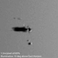
 I made a mistake in this one - I didn't include the thruster plume guards. My MER/MPF simulation for HiRISE seemed to come out about right - so fingers crossed that this will be there or there abouts as well. Still in a comissioning phase, something of a slant angle - I'd expect approx 1.5m/pixel if it's at the 120km figure mentioned earlier.
Attached thumbnail(s)
|
|||
 |
 
|
|||
 |
|
May 23 2016, 06:34 PM
Post
#2
|
|
|
Solar System Cartographer Group: Members Posts: 10197 Joined: 5-April 05 From: Canada Member No.: 227 |
I think you are right about topographic maps. We have this problem everywhere on the Moon. Consider the locations of the Ranger 4 and Lunar Orbiter impacts on the lunar far side. When they occurred we knew nothing about farside topography, so the calculations combined the best estimate of trajectory with a spherical moon to predict the impact location. Today we could re-do the analysis with LOLA topography to get a much better idea of the location. But as far as I know the re-analysis has never been done.
For Apollo 12 and other Earthside impacts, obviously they did have better topography to work with, but it was still quite uncertain compared with today's topography - they had not yet had even the late Apollo altimeters. So a re-analysis with LOLA topography would be really useful. The precision in those quotes is unwarranted. Incidentally, if you put those coordinates for Apollo 12 into Quickmap, the position is about 500 m south of the dark streaks I noted. Phil -------------------- ... because the Solar System ain't gonna map itself.
Also to be found posting similar content on https://mastodon.social/@PhilStooke Maps for download (free PD: https://upload.wikimedia.org/wikipedia/comm...Cartography.pdf NOTE: everything created by me which I post on UMSF is considered to be in the public domain (NOT CC, public domain) |
|
|
|
|
May 23 2016, 07:19 PM
Post
#3
|
|||
|
Junior Member Group: Members Posts: 62 Joined: 30-July 09 Member No.: 4887 |
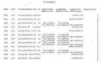
"APOLLO MISSION 12, TRAJECTORY RECONSTRUCTION AND POSTFLIGHT ANALYSIS VOLUME 1"
An excerpt: "The rev 34 (deorbit) trajectory for the LM was reconstructed from MSFN doppler data from RID (Madrid, 2-way), MIL, ACN (100 observations pre-burn and 159 observations post-burn), 5 SXT shaft angles, 2 SXT trunnion angles, 7 VHF ranging points, and the thrust profile of the deorbit burn obtained from IMU accelerometer data. The converged residual statistics for all of the observations used in the fit are as follows: No. OBS. Station Type Mean Sigma 86 RID MSFN .348 cps 1.404 cps 87 MIL MSFN .235 cps 1.416 cps 86 ACN MSFN .342 cps 1.356 cps 5 CSM SXT Shaft .001 deg .019 deg 2 CSM SXT Trunnion .033 deg .128 deg 7 CSM VHF Range -470 ft 506 ft The accumulated thrust velocities in IMU platform coordinates due to the deorbit burn are: Delta Vx = -188.57 ft/sec Delta Vy = 54.15 ft/sec Delta Vz = -6.21 ft/sec The time of impact is estimated to be 149:55:16.46 GET. The selenographic coordinates of the impact point are: LATITUDE = -3.944 deg LONGITUDE -21.196 deg RADIUS = 5697847 ft Selenographic Orbit Inclination = -14.531 deg Relative Velocity Magnitude = 5517.2 ft/sec Relative Flight Path Angle = 3.717 deg" Two images from the report offer a little more data. The one shows the above mentioned 7 VHF range data points from the CSM to the LM.
|
||
|
|
|
||
 djellison Apollo Sites from LRO Jul 17 2009, 02:52 PM
 Phil Stooke Not so much an impact, more a little bonk. If tha... Nov 6 2009, 06:34 PM Ian R <kenneth williams>
Ooooh, matron!
</k... Nov 6 2009, 06:41 PM
Phil Stooke Not so much an impact, more a little bonk. If tha... Nov 6 2009, 06:34 PM Ian R <kenneth williams>
Ooooh, matron!
</k... Nov 6 2009, 06:41 PM
 eoincampbell QUOTE (Ian R @ Nov 6 2009, 10:41 AM) ... Nov 6 2009, 08:03 PM Phil Stooke Stop messin about!
Phil Nov 6 2009, 08:37 PM Phil Stooke One thing about this observation of what almost ha... Nov 6 2009, 08:44 PM Geert QUOTE (Phil Stooke @ Nov 7 2009, 03:44 AM... Nov 7 2009, 12:56 AM nprev I wonder what the odds are of serendipitous finds ... Nov 7 2009, 01:02 AM Phil Stooke "I seem to remember some of the Ranger impact... Nov 8 2009, 08:43 PM Paolo High Noon at Tranquility Base Nov 9 2009, 10:22 PM helvick Awesome. Nov 9 2009, 11:14 PM Phil Stooke Yes, that's great. You can see the ray from W... Nov 10 2009, 12:45 AM As old as Voyager QUOTE (Phil Stooke @ Nov 10 2009, 01:45 A... Nov 10 2009, 08:42 AM Hungry4info Any signs of the flag at the Apollo 11 site? If it... Nov 10 2009, 10:16 AM PDP8E QUOTE (Hungry4info @ Nov 10 2009, 05:16 A... Nov 10 2009, 02:35 PM S_Walker QUOTE (Hungry4info @ Nov 10 2009, 05:16 A... Nov 10 2009, 02:41 PM websterling I have downloaded the raw image of the Apollo 12 s... Nov 10 2009, 02:42 PM Phil Stooke I don't have the pixel location, but it's ... Nov 10 2009, 03:11 PM websterling full inline quote removed - ADMIN
Thanks, Phil.
... Nov 10 2009, 03:30 PM kenny Regarding survival of Apollo 11 flag, it's gon... Nov 10 2009, 07:48 PM Hungry4info Well see, that's what I would have expected un... Nov 11 2009, 09:43 AM kenny Hmmm, I see what you mean, Hungry. Aldrin glanced... Nov 11 2009, 01:51 PM stevesliva The comments of the flag manufacturer were simply ... Nov 11 2009, 03:20 PM Hungry4info Interesting, about the oxygen being needed.
And n... Nov 11 2009, 03:42 PM stevesliva A little google indicates that someone had nylon o... Nov 11 2009, 06:21 PM mcaplinger QUOTE (stevesliva @ Nov 11 2009, 10:21 AM... Nov 11 2009, 06:52 PM PDP8E Here is the new low orbit Apollo 11 site, destripe... Nov 12 2009, 03:30 AM ilbasso I had a little trouble matching up the components ... Nov 12 2009, 03:52 AM Phil Stooke I was looking at those things too. I agree with y... Nov 12 2009, 04:34 AM Maquis Rocks were our preliminary conclusion as well. How... Nov 13 2009, 02:35 PM PDP8E Maquis,
Interesting chain of evidence on your li... Nov 13 2009, 02:54 PM Phil Stooke I agree with this - I was thinking of the rock at ... Nov 13 2009, 03:27 PM BUDU Am I seeing the flag?
http://img5.imageshack.us/im... Nov 14 2009, 03:13 PM Paolo The LRRR cover is visible in an amazing number of ... Nov 14 2009, 04:18 PM Maquis QUOTE (Paolo @ Nov 14 2009, 05:18 PM) It ... Nov 16 2009, 09:06 PM Stu New image of Apollo 14 landing site up on LRO site... Jan 30 2010, 08:56 AM ilbasso Nathaniel Burton-Bradford has posted these anaglyp... Apr 15 2010, 03:52 AM monty python WOW! The 3d treatment really brings out the d... Apr 15 2010, 06:54 AM kenny QUOTE (ilbasso @ Apr 15 2010, 04:52 AM) N... Apr 15 2010, 01:16 PM nprev Cool they are indeed. Is the vertical scale exagge... Apr 15 2010, 09:46 AM djellison Making anaglyphs from stereo pairs - it's almo... Apr 15 2010, 10:57 AM john_s QUOTE (djellison @ Apr 15 2010, 10:57 AM)... Apr 15 2010, 01:42 PM FordPrefect QUOTE (djellison @ Apr 15 2010, 11:57 AM)... Apr 22 2010, 07:16 PM nprev Ah. Makes sense--thanks, Doug.
I was actually wo... Apr 15 2010, 11:24 AM nprev Huh. Yeah, I just did; never noticed that before. ... Apr 15 2010, 03:28 PM Bill Harris I see that the location of the Apollo 15 LRR (Luna... Apr 16 2010, 08:01 PM dmg QUOTE (Bill Harris @ Apr 16 2010, 12:01 P... Apr 23 2010, 10:55 PM FordPrefect QUOTE (dmg @ Apr 23 2010, 11:55 PM) I... Apr 24 2010, 10:56 AM djellison If the sun were directly 'behind' the spac... Apr 16 2010, 08:06 PM Hungry4info With LRO being in a polar orbit, I don't see w... Apr 16 2010, 08:23 PM nprev The timing would still be pretty finicky; not sure... Apr 16 2010, 09:43 PM Phil Stooke It may not be a good idea to look for that reflect... Apr 16 2010, 09:50 PM ugordan They can (and do IIRC) turn LOLA off every time th... Apr 16 2010, 10:09 PM elakdawalla They'd better! LOLA would be fried if the... Apr 16 2010, 10:37 PM Bill Harris I'm thinking it could be possible-- the LRO-LR... Apr 16 2010, 11:31 PM djellison The way HiRISE DEM's are made, generally speak... Apr 22 2010, 08:08 PM Ian R Here's a 'locator' for the Apollo 15 s... Apr 23 2010, 11:33 AM dshaffer Excellent - very helpful! Apr 23 2010, 12:10 PM Ian R Here's a couple of views of the Apollo 15 land... Apr 30 2010, 08:10 PM Ian R Here's a version of the ascent mosaic that is ... Apr 30 2010, 09:42 PM JohnVV QUOTE The way HiRISE DEM's are made, generally... Apr 30 2010, 10:03 PM jasedm Not much seems to have happened in 40 years - I ca... May 1 2010, 12:49 AM ilbasso Great comparison indeed! Could one generate a... May 1 2010, 02:46 PM Phil Stooke Here's Apollo 16's stop on the rim of Nort... Jul 8 2010, 02:20 PM JohnVV every time i see this thread in my inbox i think ... Jul 8 2010, 03:15 PM Phil Stooke There's nothing else to do in London, Ontario... Jul 8 2010, 08:46 PM JohnVV London, Ontario!
i have family in blennum
h... Jul 8 2010, 09:04 PM Phil Stooke Apollo 17 Station 6, the big broken boulder 'S... Oct 8 2010, 11:27 AM FordPrefect Wow, that's a great image of Tracy's rock.... Oct 8 2010, 10:17 PM ilbasso I came across this video of LRO shots of the Apoll... Oct 23 2010, 01:45 PM ugordan Nice video, but I think the author's at times ... Oct 23 2010, 06:18 PM JohnVV QUOTE Actually, scratch that, it clearly states me... Oct 23 2010, 07:10 PM ugordan Yeah, I didn't feel it was necessary to specif... Oct 23 2010, 07:54 PM Phil Stooke The Apollo lunar Module ascent stages have been di... Mar 1 2011, 12:58 AM AndyG These must have been fairly grazing impacts. Presu... Mar 1 2011, 09:46 AM Phil Stooke Yes, it does match reasonably well, just as my ear... Mar 1 2011, 11:55 AM machi Interesting animated gifs!
Evidently I didn... May 8 2012, 11:10 PM stevesliva For what it's worth, you have to take the idea... May 10 2012, 04:52 PM Mr Valiant Good call. Many of the corrosive forces that take ... May 11 2012, 02:46 PM wildespace A very cool and informative way to view Apollo sit... Jul 25 2015, 08:11 AM Phil Stooke One of the puzzles about LRO imaging of Apollo sit... May 21 2016, 12:03 AM James Fincannon QUOTE (Phil Stooke @ May 21 2016, 01:03 A... May 23 2016, 04:44 PM nprev Newbie questions: With respect to the image orient... May 21 2016, 08:37 AM Phil Stooke You're a newbie?
The spacecraft approached fr... May 21 2016, 04:24 PM dvandorn All of the LM ascent stages were grazing impacts, ... May 21 2016, 10:55 PM stevesliva QUOTE (dvandorn @ May 21 2016, 05:55 PM) ... May 23 2016, 07:00 AM Phil Stooke "If you ran lines back along the streaks, wou... May 22 2016, 09:53 PM dvandorn QUOTE (Phil Stooke @ May 22 2016, 04:53 P... May 24 2016, 02:44 AM Phil Stooke Follow-up on the Apollo 12 - possible - Lunar Modu... Sep 12 2016, 08:07 PM john_s Nice work! It looks quite convincing to me. ... Sep 13 2016, 02:55 AM Phil Stooke Thanks, John. The shadow-cancelling method is sur... Sep 13 2016, 12:12 PM Phil Stooke Another example of the shadow-cancelling method. ... Sep 13 2016, 07:32 PM Phil Stooke Allow me to introduce to you.... the Apollo 14 LM ... Nov 2 2016, 04:46 PM Ian R Nice discovery Phil, and sad news about Ewen Whita... Nov 3 2016, 10:31 AM Phil Stooke Thanks. The book is coming along pretty well. It... Nov 3 2016, 12:18 PM Phil Stooke Another Apollo LM ascent stage? I think so. I be... Feb 21 2017, 06:23 PM James Fincannon [quote name='Phil Stooke' date='Feb 21... Feb 21 2017, 07:13 PM Phil Stooke That has to be one of the most puzzling things I h... Feb 21 2017, 08:43 PM
eoincampbell QUOTE (Ian R @ Nov 6 2009, 10:41 AM) ... Nov 6 2009, 08:03 PM Phil Stooke Stop messin about!
Phil Nov 6 2009, 08:37 PM Phil Stooke One thing about this observation of what almost ha... Nov 6 2009, 08:44 PM Geert QUOTE (Phil Stooke @ Nov 7 2009, 03:44 AM... Nov 7 2009, 12:56 AM nprev I wonder what the odds are of serendipitous finds ... Nov 7 2009, 01:02 AM Phil Stooke "I seem to remember some of the Ranger impact... Nov 8 2009, 08:43 PM Paolo High Noon at Tranquility Base Nov 9 2009, 10:22 PM helvick Awesome. Nov 9 2009, 11:14 PM Phil Stooke Yes, that's great. You can see the ray from W... Nov 10 2009, 12:45 AM As old as Voyager QUOTE (Phil Stooke @ Nov 10 2009, 01:45 A... Nov 10 2009, 08:42 AM Hungry4info Any signs of the flag at the Apollo 11 site? If it... Nov 10 2009, 10:16 AM PDP8E QUOTE (Hungry4info @ Nov 10 2009, 05:16 A... Nov 10 2009, 02:35 PM S_Walker QUOTE (Hungry4info @ Nov 10 2009, 05:16 A... Nov 10 2009, 02:41 PM websterling I have downloaded the raw image of the Apollo 12 s... Nov 10 2009, 02:42 PM Phil Stooke I don't have the pixel location, but it's ... Nov 10 2009, 03:11 PM websterling full inline quote removed - ADMIN
Thanks, Phil.
... Nov 10 2009, 03:30 PM kenny Regarding survival of Apollo 11 flag, it's gon... Nov 10 2009, 07:48 PM Hungry4info Well see, that's what I would have expected un... Nov 11 2009, 09:43 AM kenny Hmmm, I see what you mean, Hungry. Aldrin glanced... Nov 11 2009, 01:51 PM stevesliva The comments of the flag manufacturer were simply ... Nov 11 2009, 03:20 PM Hungry4info Interesting, about the oxygen being needed.
And n... Nov 11 2009, 03:42 PM stevesliva A little google indicates that someone had nylon o... Nov 11 2009, 06:21 PM mcaplinger QUOTE (stevesliva @ Nov 11 2009, 10:21 AM... Nov 11 2009, 06:52 PM PDP8E Here is the new low orbit Apollo 11 site, destripe... Nov 12 2009, 03:30 AM ilbasso I had a little trouble matching up the components ... Nov 12 2009, 03:52 AM Phil Stooke I was looking at those things too. I agree with y... Nov 12 2009, 04:34 AM Maquis Rocks were our preliminary conclusion as well. How... Nov 13 2009, 02:35 PM PDP8E Maquis,
Interesting chain of evidence on your li... Nov 13 2009, 02:54 PM Phil Stooke I agree with this - I was thinking of the rock at ... Nov 13 2009, 03:27 PM BUDU Am I seeing the flag?
http://img5.imageshack.us/im... Nov 14 2009, 03:13 PM Paolo The LRRR cover is visible in an amazing number of ... Nov 14 2009, 04:18 PM Maquis QUOTE (Paolo @ Nov 14 2009, 05:18 PM) It ... Nov 16 2009, 09:06 PM Stu New image of Apollo 14 landing site up on LRO site... Jan 30 2010, 08:56 AM ilbasso Nathaniel Burton-Bradford has posted these anaglyp... Apr 15 2010, 03:52 AM monty python WOW! The 3d treatment really brings out the d... Apr 15 2010, 06:54 AM kenny QUOTE (ilbasso @ Apr 15 2010, 04:52 AM) N... Apr 15 2010, 01:16 PM nprev Cool they are indeed. Is the vertical scale exagge... Apr 15 2010, 09:46 AM djellison Making anaglyphs from stereo pairs - it's almo... Apr 15 2010, 10:57 AM john_s QUOTE (djellison @ Apr 15 2010, 10:57 AM)... Apr 15 2010, 01:42 PM FordPrefect QUOTE (djellison @ Apr 15 2010, 11:57 AM)... Apr 22 2010, 07:16 PM nprev Ah. Makes sense--thanks, Doug.
I was actually wo... Apr 15 2010, 11:24 AM nprev Huh. Yeah, I just did; never noticed that before. ... Apr 15 2010, 03:28 PM Bill Harris I see that the location of the Apollo 15 LRR (Luna... Apr 16 2010, 08:01 PM dmg QUOTE (Bill Harris @ Apr 16 2010, 12:01 P... Apr 23 2010, 10:55 PM FordPrefect QUOTE (dmg @ Apr 23 2010, 11:55 PM) I... Apr 24 2010, 10:56 AM djellison If the sun were directly 'behind' the spac... Apr 16 2010, 08:06 PM Hungry4info With LRO being in a polar orbit, I don't see w... Apr 16 2010, 08:23 PM nprev The timing would still be pretty finicky; not sure... Apr 16 2010, 09:43 PM Phil Stooke It may not be a good idea to look for that reflect... Apr 16 2010, 09:50 PM ugordan They can (and do IIRC) turn LOLA off every time th... Apr 16 2010, 10:09 PM elakdawalla They'd better! LOLA would be fried if the... Apr 16 2010, 10:37 PM Bill Harris I'm thinking it could be possible-- the LRO-LR... Apr 16 2010, 11:31 PM djellison The way HiRISE DEM's are made, generally speak... Apr 22 2010, 08:08 PM Ian R Here's a 'locator' for the Apollo 15 s... Apr 23 2010, 11:33 AM dshaffer Excellent - very helpful! Apr 23 2010, 12:10 PM Ian R Here's a couple of views of the Apollo 15 land... Apr 30 2010, 08:10 PM Ian R Here's a version of the ascent mosaic that is ... Apr 30 2010, 09:42 PM JohnVV QUOTE The way HiRISE DEM's are made, generally... Apr 30 2010, 10:03 PM jasedm Not much seems to have happened in 40 years - I ca... May 1 2010, 12:49 AM ilbasso Great comparison indeed! Could one generate a... May 1 2010, 02:46 PM Phil Stooke Here's Apollo 16's stop on the rim of Nort... Jul 8 2010, 02:20 PM JohnVV every time i see this thread in my inbox i think ... Jul 8 2010, 03:15 PM Phil Stooke There's nothing else to do in London, Ontario... Jul 8 2010, 08:46 PM JohnVV London, Ontario!
i have family in blennum
h... Jul 8 2010, 09:04 PM Phil Stooke Apollo 17 Station 6, the big broken boulder 'S... Oct 8 2010, 11:27 AM FordPrefect Wow, that's a great image of Tracy's rock.... Oct 8 2010, 10:17 PM ilbasso I came across this video of LRO shots of the Apoll... Oct 23 2010, 01:45 PM ugordan Nice video, but I think the author's at times ... Oct 23 2010, 06:18 PM JohnVV QUOTE Actually, scratch that, it clearly states me... Oct 23 2010, 07:10 PM ugordan Yeah, I didn't feel it was necessary to specif... Oct 23 2010, 07:54 PM Phil Stooke The Apollo lunar Module ascent stages have been di... Mar 1 2011, 12:58 AM AndyG These must have been fairly grazing impacts. Presu... Mar 1 2011, 09:46 AM Phil Stooke Yes, it does match reasonably well, just as my ear... Mar 1 2011, 11:55 AM machi Interesting animated gifs!
Evidently I didn... May 8 2012, 11:10 PM stevesliva For what it's worth, you have to take the idea... May 10 2012, 04:52 PM Mr Valiant Good call. Many of the corrosive forces that take ... May 11 2012, 02:46 PM wildespace A very cool and informative way to view Apollo sit... Jul 25 2015, 08:11 AM Phil Stooke One of the puzzles about LRO imaging of Apollo sit... May 21 2016, 12:03 AM James Fincannon QUOTE (Phil Stooke @ May 21 2016, 01:03 A... May 23 2016, 04:44 PM nprev Newbie questions: With respect to the image orient... May 21 2016, 08:37 AM Phil Stooke You're a newbie?
The spacecraft approached fr... May 21 2016, 04:24 PM dvandorn All of the LM ascent stages were grazing impacts, ... May 21 2016, 10:55 PM stevesliva QUOTE (dvandorn @ May 21 2016, 05:55 PM) ... May 23 2016, 07:00 AM Phil Stooke "If you ran lines back along the streaks, wou... May 22 2016, 09:53 PM dvandorn QUOTE (Phil Stooke @ May 22 2016, 04:53 P... May 24 2016, 02:44 AM Phil Stooke Follow-up on the Apollo 12 - possible - Lunar Modu... Sep 12 2016, 08:07 PM john_s Nice work! It looks quite convincing to me. ... Sep 13 2016, 02:55 AM Phil Stooke Thanks, John. The shadow-cancelling method is sur... Sep 13 2016, 12:12 PM Phil Stooke Another example of the shadow-cancelling method. ... Sep 13 2016, 07:32 PM Phil Stooke Allow me to introduce to you.... the Apollo 14 LM ... Nov 2 2016, 04:46 PM Ian R Nice discovery Phil, and sad news about Ewen Whita... Nov 3 2016, 10:31 AM Phil Stooke Thanks. The book is coming along pretty well. It... Nov 3 2016, 12:18 PM Phil Stooke Another Apollo LM ascent stage? I think so. I be... Feb 21 2017, 06:23 PM James Fincannon [quote name='Phil Stooke' date='Feb 21... Feb 21 2017, 07:13 PM Phil Stooke That has to be one of the most puzzling things I h... Feb 21 2017, 08:43 PM |

|
Lo-Fi Version | Time is now: 24th June 2024 - 12:59 PM |
|
RULES AND GUIDELINES Please read the Forum Rules and Guidelines before posting. IMAGE COPYRIGHT |
OPINIONS AND MODERATION Opinions expressed on UnmannedSpaceflight.com are those of the individual posters and do not necessarily reflect the opinions of UnmannedSpaceflight.com or The Planetary Society. The all-volunteer UnmannedSpaceflight.com moderation team is wholly independent of The Planetary Society. The Planetary Society has no influence over decisions made by the UnmannedSpaceflight.com moderators. |
SUPPORT THE FORUM Unmannedspaceflight.com is funded by the Planetary Society. Please consider supporting our work and many other projects by donating to the Society or becoming a member. |
|