MSL at Rocknest, First scoop samples - sols 57-101 |

MSL at Rocknest, First scoop samples - sols 57-101 |
 Oct 3 2012, 12:30 AM Oct 3 2012, 12:30 AM
Post
#1
|
|
 Administrator  Group: Admin Posts: 5172 Joined: 4-August 05 From: Pasadena, CA, USA, Earth Member No.: 454 |
Curiosity has put more than 400 meters on the odometer and tosol (sol 56) she bumped up to a sand drift that we now know (via Twitter) is named Rocknest and will be the site of the first sample grab. In last week's press briefing, John Grotzinger warned that we will be here for "what seems like a very long time," 2-3 weeks. They will have to run several samples through the SA-SPaH (Sample Acquisition, Processing and Handling subsystem, pronounced "Saw-spa") and in particular CHIMRA (Collection and Handling for In situ Martian Rock Analysis, pronounced "chimera") in order to "clean" it of any remaining Earthly contamination with good Mars dirt before they deliver the first sample to SAM or Chemin. So this seems like a good place to start a new thread.
As usual, discuss stuff that happened through sol 56 in the previous thread. -------------------- My website - My Patreon - @elakdawalla on Twitter - Please support unmannedspaceflight.com by donating here.
|
 |
 
|
 |
|
Oct 7 2012, 01:43 PM
Post
#2
|
|
|
Senior Member Group: Members Posts: 3516 Joined: 4-November 05 From: North Wales Member No.: 542 |
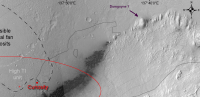
For referring to features in panoramas a few informal landmark names can be useful. We already have Rocky Point. Some of us probably have our own private names for things (or is it just me?). Here's one I'd like to share. For me there's only one possible name for the hill at the leftmost visible extremity of Mt Sharp. It's Dumgoyne: http://www.google.co.uk/imgres?imgurl=http...BA&dur=3713
|
|
|
|
|
Oct 7 2012, 02:42 PM
Post
#3
|
|||
|
Member Group: Members Posts: 252 Joined: 5-May 05 From: Mississippi (USA) Member No.: 379 |
QUOTE (ngunn @ Oct 7 2012, 08:43 AM)  For referring to features in panoramas a few informal landmark names can be useful. We already have Rocky Point....... For me there's only one possible name for the hill at the leftmost visible extremity of Mt Sharp. It's Dumgoyne: ... Until, and unless, there is an official name that sounds good to me. If this is the overhead view of Dumgoyne it should remain in view in the N.E. for some time.
I couldn't find a good 2D horizontal view of Dumgoyne so I just marked it on my crop of EdTruthan's anaglyph.
|
||
|
|
|
||
|
Oct 7 2012, 04:22 PM
Post
#4
|
|
|
Senior Member Group: Members Posts: 3516 Joined: 4-November 05 From: North Wales Member No.: 542 |
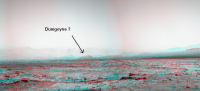
QUOTE (stewjack @ Oct 7 2012, 03:42 PM) I couldn't find a good 2D horizontal view of Dumgoyne so I just marked it on my crop of EdTruthan's anaglyph. That's the one. It shows up rather well on this crop from Stu: http://www.unmannedspaceflight.com/index.p...st&id=28283 EDIT: Here's another view of the Scottish version showing the "crater rim" beyond: http://s0.geograph.org.uk/geophotos/02/48/...38_bd117844.jpg And back to Mars: http://mars.jpl.nasa.gov/msl-raw-images/ms...0000E1_DXXX.jpg |
|
|
|
 elakdawalla MSL at Rocknest Oct 3 2012, 12:30 AM
 belleraphon1 Putting this here because assume they will discuss... Oct 3 2012, 10:59 AM charborob Sol 57 navcam anaglyph:
Oct 3 2012, 08:44 PM
belleraphon1 Putting this here because assume they will discuss... Oct 3 2012, 10:59 AM charborob Sol 57 navcam anaglyph:
Oct 3 2012, 08:44 PM
 ngunn QUOTE (charborob @ Oct 3 2012, 09:44 PM) ... Oct 3 2012, 09:58 PM ronald
Stomp! Oct 3 2012, 08:47 PM Eyesonmars QUOTE (ronald @ Oct 3 2012, 08:47 PM)
S... Oct 4 2012, 07:15 PM Joffan QUOTE (Eyesonmars @ Oct 4 2012, 01:15 PM)... Oct 5 2012, 05:29 AM renee Actually, this says a lot about the plasticity of ... Oct 3 2012, 09:48 PM ronald QUOTE (renee @ Oct 3 2012, 11:48 PM) Actu... Oct 3 2012, 10:14 PM Ant103 Navcam pan of Sol 57. Anaglyp version is fine too ... Oct 3 2012, 10:12 PM Ant103 I can recall that the martian soil is acting like ... Oct 3 2012, 10:26 PM ronald The navcam pans are really nice!
I hope it i... Oct 3 2012, 10:29 PM stewjack QUOTE (ronald @ Oct 3 2012, 05:29 PM) The... Oct 4 2012, 05:51 PM Ant103 Oh no, that's not a problem. But yes, with jpe... Oct 3 2012, 11:41 PM renee "Just looking at the images as an amateur I w... Oct 4 2012, 12:12 AM Reed QUOTE (renee @ Oct 3 2012, 05:12 PM) Thar... Oct 4 2012, 12:57 AM djellison QUOTE (renee @ Oct 3 2012, 04:12 PM) Thar... Oct 4 2012, 01:14 AM centsworth_II For comparison, here is from Spirit on sols 72 and... Oct 4 2012, 02:24 AM renee Actually, now that I see it, you're right. I j... Oct 4 2012, 05:27 AM udolein Wheel digging at rocknest on Sol 57:
click here ... Oct 4 2012, 01:57 PM udolein ... and from the MastCam:
click to enlarge the a... Oct 4 2012, 02:00 PM Doc 8gs! I guess Phoenix's poor performance du... Oct 4 2012, 06:26 PM elakdawalla Sol 58 images coming down now. I like this one:
... Oct 4 2012, 09:07 PM udolein Animation of arm movement between 1 pm and 3 pm lo... Oct 4 2012, 09:49 PM jmknapp QUOTE (udolein @ Oct 4 2012, 04:49 PM) Un... Oct 5 2012, 12:03 AM brellis Re: Emily's post #466 pic - that really looks ... Oct 4 2012, 10:11 PM elakdawalla To me it looks exactly like flour. Completely dry,... Oct 4 2012, 10:18 PM ollopa QUOTE (elakdawalla @ Oct 4 2012, 11:18 PM... Oct 5 2012, 12:44 AM dvandorn QUOTE (ollopa @ Oct 4 2012, 07:44 PM) And... Oct 5 2012, 01:59 AM ronald Really nice MAHLI images coming in - SOL 58:
I ... Oct 4 2012, 10:26 PM djellison Exacly like fine flour, cornflour, talc, exception... Oct 4 2012, 11:57 PM Doc Seeing MAHLI's images of the scuffed ripple... Oct 5 2012, 12:11 AM dvandorn QUOTE (Doc @ Oct 4 2012, 07:11 PM) Seeing... Oct 5 2012, 01:49 AM EdTruthan Horizon flattened animated anaglyph GIF of the Sol... Oct 5 2012, 12:39 AM kenny QUOTE (elakdawalla @ Oct 4 2012, 10:07 PM... Oct 5 2012, 10:08 AM paraisosdelsistemasolar Two different views of the wheel track. You can pu... Oct 5 2012, 12:47 PM EdTruthan ...makes for a nice stereo pairing too, especially... Oct 5 2012, 06:24 PM elakdawalla Sol 59 images arriving now. Just a stomp to the le... Oct 5 2012, 09:26 PM Joffan QUOTE (elakdawalla @ Oct 5 2012, 03:26 PM... Oct 5 2012, 11:01 PM EdTruthan Sol 59 Front Hazcam - looks like they've backe... Oct 5 2012, 10:11 PM Explorer1 The dune in front of MSL now is about half the hei... Oct 6 2012, 03:51 AM brellis It's like starting Chapter 2 of a really fanta... Oct 6 2012, 04:17 AM James Sorenson Dropping in with new images... Oct 6 2012, 06:51 AM udolein Lots of MAHLI activities on sol 60:
enlarged ani... Oct 6 2012, 10:28 PM udolein It's astonishing for me how fast the data are ... Oct 6 2012, 10:35 PM Ant103 It's a little late for this but :
Sol 57 mosa... Oct 6 2012, 10:56 PM Doc I like the timeline on your web Ant! Definitel... Oct 7 2012, 12:28 AM EdTruthan Damien's (Ant103) much better at seamless stit... Oct 7 2012, 12:29 AM fredk QUOTE (EdTruthan @ Oct 7 2012, 01:29 AM) ... Oct 7 2012, 01:57 AM stewjack QUOTE (EdTruthan @ Oct 6 2012, 07:29 PM) ... Oct 7 2012, 02:43 AM ngunn QUOTE (stewjack @ Oct 7 2012, 03:43 AM) T... Oct 7 2012, 08:46 AM stewjack QUOTE (ngunn @ Oct 7 2012, 03:46 AM) It w... Oct 8 2012, 02:29 AM Ondaweb QUOTE (stewjack @ Oct 6 2012, 09:43 PM) H... Oct 7 2012, 09:54 PM Doc MAHLI took a shot of the left middle and back whee... Oct 7 2012, 12:46 AM jmknapp QUOTE (Doc @ Oct 6 2012, 08:46 PM) MAHLI ... Oct 7 2012, 07:23 PM walfy QUOTE (jmknapp @ Oct 7 2012, 11:23 AM) Th... Oct 7 2012, 08:01 PM mcaplinger QUOTE (jmknapp @ Oct 7 2012, 12:23 PM) Th... Oct 7 2012, 08:10 PM ugordan QUOTE (mcaplinger @ Oct 7 2012, 10:10 PM)... Oct 7 2012, 08:16 PM mcaplinger QUOTE (ugordan @ Oct 7 2012, 01:16 PM) Ar... Oct 7 2012, 08:27 PM James Sorenson I second what Ed said, I'm sure Ant is gonna d... Oct 7 2012, 02:08 AM James Sorenson The deck on Sol-60. Oct 7 2012, 09:06 AM jvandriel Sol 59-60
The Navcam R Panoramic view.
Jan van Dr... Oct 7 2012, 09:28 AM Ant103 Better for stitching panoramic, I don't know ... Oct 7 2012, 03:30 PM Phil Stooke Beautiful! Here is a circular version of it.
... Oct 7 2012, 03:39 PM Stu If time/engineering requirements allow, now might ... Oct 7 2012, 07:22 PM elakdawalla QUOTE (mcaplinger @ Aug 16 2012, 09:09 AM... Oct 7 2012, 08:01 PM Stu First scoop..!
Oct 7 2012, 09:49 PM Stu One small scoop for a rover, but another giant lea... Oct 8 2012, 12:56 AM belleraphon1 Oh.... luv this Stu..... I remember Surveyor...
C... Oct 8 2012, 02:04 AM ngunn I was referring to the small rise in the middle of... Oct 8 2012, 07:54 AM stewjack QUOTE (ngunn @ Oct 8 2012, 02:54 AM) I wa... Oct 8 2012, 08:12 PM ngunn QUOTE (stewjack @ Oct 8 2012, 09:12 PM) I... Oct 8 2012, 08:28 PM EdTruthan QUOTE (ngunn @ Oct 8 2012, 01:28 PM) On P... Oct 8 2012, 09:56 PM ElkGroveDan QUOTE (EdTruthan @ Oct 8 2012, 01:56 PM) ... Oct 8 2012, 10:35 PM kenny Just to mention in passing, I was walking near the... Oct 8 2012, 10:39 AM jmknapp Anyone know why the mastcam images taken with the ... Oct 8 2012, 11:31 AM ronald QUOTE (jmknapp @ Oct 8 2012, 01:31 PM) An... Oct 8 2012, 11:48 AM fredk QUOTE (jmknapp @ Oct 8 2012, 12:31 PM) An... Oct 8 2012, 02:53 PM Floyd Re: Glenelg, Scotland astro event
How I would lov... Oct 8 2012, 11:43 AM kenny QUOTE (Floyd @ Oct 8 2012, 12:43 PM) Re: ... Oct 8 2012, 01:13 PM eoincampbell Kenny, wish I could be there, especially for the M... Oct 8 2012, 03:55 PM kenny Their rhythms are off-beat and somewhat alien, yet... Oct 8 2012, 05:29 PM Stu Interesting. There's a JPL YouTube film of dus... Oct 8 2012, 07:09 PM Ant103 Maybe it's a movie made on-board the rover. Bu... Oct 8 2012, 07:29 PM elakdawalla No, it's just that Malin is holding some (usua... Oct 8 2012, 07:36 PM mcaplinger QUOTE (elakdawalla @ Oct 8 2012, 12:36 PM... Oct 8 2012, 07:55 PM elakdawalla QUOTE (mcaplinger @ Oct 8 2012, 11:55 AM)... Oct 8 2012, 08:00 PM EdTruthan QUOTE (mcaplinger @ Oct 8 2012, 12:55 PM)... Oct 8 2012, 08:23 PM EdTruthan QUOTE (elakdawalla @ Oct 8 2012, 12:36 PM... Oct 8 2012, 07:58 PM fredk No obvious sign of dust being carried away by wind... Oct 8 2012, 07:49 PM ronald Nice picture of the first scoop sample. Near the b... Oct 8 2012, 09:50 PM Doc I too noticed it ronald. Here is a cropped view
... Oct 8 2012, 09:58 PM ngunn Responding to Ed Truthan: Yes I think that's i... Oct 8 2012, 10:10 PM Doc Sub frame images from the video are pouring in and... Oct 8 2012, 10:26 PM Jam Butty Shake Rattle & Roll
Sol 61 scoop shaking,
3 f... Oct 8 2012, 10:29 PM Phil Stooke Curiosity can get to places even a RAV4 can't ... Oct 8 2012, 10:37 PM Pando She already has, Phil. Oct 8 2012, 10:44 PM
ngunn QUOTE (charborob @ Oct 3 2012, 09:44 PM) ... Oct 3 2012, 09:58 PM ronald
Stomp! Oct 3 2012, 08:47 PM Eyesonmars QUOTE (ronald @ Oct 3 2012, 08:47 PM)
S... Oct 4 2012, 07:15 PM Joffan QUOTE (Eyesonmars @ Oct 4 2012, 01:15 PM)... Oct 5 2012, 05:29 AM renee Actually, this says a lot about the plasticity of ... Oct 3 2012, 09:48 PM ronald QUOTE (renee @ Oct 3 2012, 11:48 PM) Actu... Oct 3 2012, 10:14 PM Ant103 Navcam pan of Sol 57. Anaglyp version is fine too ... Oct 3 2012, 10:12 PM Ant103 I can recall that the martian soil is acting like ... Oct 3 2012, 10:26 PM ronald The navcam pans are really nice!
I hope it i... Oct 3 2012, 10:29 PM stewjack QUOTE (ronald @ Oct 3 2012, 05:29 PM) The... Oct 4 2012, 05:51 PM Ant103 Oh no, that's not a problem. But yes, with jpe... Oct 3 2012, 11:41 PM renee "Just looking at the images as an amateur I w... Oct 4 2012, 12:12 AM Reed QUOTE (renee @ Oct 3 2012, 05:12 PM) Thar... Oct 4 2012, 12:57 AM djellison QUOTE (renee @ Oct 3 2012, 04:12 PM) Thar... Oct 4 2012, 01:14 AM centsworth_II For comparison, here is from Spirit on sols 72 and... Oct 4 2012, 02:24 AM renee Actually, now that I see it, you're right. I j... Oct 4 2012, 05:27 AM udolein Wheel digging at rocknest on Sol 57:
click here ... Oct 4 2012, 01:57 PM udolein ... and from the MastCam:
click to enlarge the a... Oct 4 2012, 02:00 PM Doc 8gs! I guess Phoenix's poor performance du... Oct 4 2012, 06:26 PM elakdawalla Sol 58 images coming down now. I like this one:
... Oct 4 2012, 09:07 PM udolein Animation of arm movement between 1 pm and 3 pm lo... Oct 4 2012, 09:49 PM jmknapp QUOTE (udolein @ Oct 4 2012, 04:49 PM) Un... Oct 5 2012, 12:03 AM brellis Re: Emily's post #466 pic - that really looks ... Oct 4 2012, 10:11 PM elakdawalla To me it looks exactly like flour. Completely dry,... Oct 4 2012, 10:18 PM ollopa QUOTE (elakdawalla @ Oct 4 2012, 11:18 PM... Oct 5 2012, 12:44 AM dvandorn QUOTE (ollopa @ Oct 4 2012, 07:44 PM) And... Oct 5 2012, 01:59 AM ronald Really nice MAHLI images coming in - SOL 58:
I ... Oct 4 2012, 10:26 PM djellison Exacly like fine flour, cornflour, talc, exception... Oct 4 2012, 11:57 PM Doc Seeing MAHLI's images of the scuffed ripple... Oct 5 2012, 12:11 AM dvandorn QUOTE (Doc @ Oct 4 2012, 07:11 PM) Seeing... Oct 5 2012, 01:49 AM EdTruthan Horizon flattened animated anaglyph GIF of the Sol... Oct 5 2012, 12:39 AM kenny QUOTE (elakdawalla @ Oct 4 2012, 10:07 PM... Oct 5 2012, 10:08 AM paraisosdelsistemasolar Two different views of the wheel track. You can pu... Oct 5 2012, 12:47 PM EdTruthan ...makes for a nice stereo pairing too, especially... Oct 5 2012, 06:24 PM elakdawalla Sol 59 images arriving now. Just a stomp to the le... Oct 5 2012, 09:26 PM Joffan QUOTE (elakdawalla @ Oct 5 2012, 03:26 PM... Oct 5 2012, 11:01 PM EdTruthan Sol 59 Front Hazcam - looks like they've backe... Oct 5 2012, 10:11 PM Explorer1 The dune in front of MSL now is about half the hei... Oct 6 2012, 03:51 AM brellis It's like starting Chapter 2 of a really fanta... Oct 6 2012, 04:17 AM James Sorenson Dropping in with new images... Oct 6 2012, 06:51 AM udolein Lots of MAHLI activities on sol 60:
enlarged ani... Oct 6 2012, 10:28 PM udolein It's astonishing for me how fast the data are ... Oct 6 2012, 10:35 PM Ant103 It's a little late for this but :
Sol 57 mosa... Oct 6 2012, 10:56 PM Doc I like the timeline on your web Ant! Definitel... Oct 7 2012, 12:28 AM EdTruthan Damien's (Ant103) much better at seamless stit... Oct 7 2012, 12:29 AM fredk QUOTE (EdTruthan @ Oct 7 2012, 01:29 AM) ... Oct 7 2012, 01:57 AM stewjack QUOTE (EdTruthan @ Oct 6 2012, 07:29 PM) ... Oct 7 2012, 02:43 AM ngunn QUOTE (stewjack @ Oct 7 2012, 03:43 AM) T... Oct 7 2012, 08:46 AM stewjack QUOTE (ngunn @ Oct 7 2012, 03:46 AM) It w... Oct 8 2012, 02:29 AM Ondaweb QUOTE (stewjack @ Oct 6 2012, 09:43 PM) H... Oct 7 2012, 09:54 PM Doc MAHLI took a shot of the left middle and back whee... Oct 7 2012, 12:46 AM jmknapp QUOTE (Doc @ Oct 6 2012, 08:46 PM) MAHLI ... Oct 7 2012, 07:23 PM walfy QUOTE (jmknapp @ Oct 7 2012, 11:23 AM) Th... Oct 7 2012, 08:01 PM mcaplinger QUOTE (jmknapp @ Oct 7 2012, 12:23 PM) Th... Oct 7 2012, 08:10 PM ugordan QUOTE (mcaplinger @ Oct 7 2012, 10:10 PM)... Oct 7 2012, 08:16 PM mcaplinger QUOTE (ugordan @ Oct 7 2012, 01:16 PM) Ar... Oct 7 2012, 08:27 PM James Sorenson I second what Ed said, I'm sure Ant is gonna d... Oct 7 2012, 02:08 AM James Sorenson The deck on Sol-60. Oct 7 2012, 09:06 AM jvandriel Sol 59-60
The Navcam R Panoramic view.
Jan van Dr... Oct 7 2012, 09:28 AM Ant103 Better for stitching panoramic, I don't know ... Oct 7 2012, 03:30 PM Phil Stooke Beautiful! Here is a circular version of it.
... Oct 7 2012, 03:39 PM Stu If time/engineering requirements allow, now might ... Oct 7 2012, 07:22 PM elakdawalla QUOTE (mcaplinger @ Aug 16 2012, 09:09 AM... Oct 7 2012, 08:01 PM Stu First scoop..!
Oct 7 2012, 09:49 PM Stu One small scoop for a rover, but another giant lea... Oct 8 2012, 12:56 AM belleraphon1 Oh.... luv this Stu..... I remember Surveyor...
C... Oct 8 2012, 02:04 AM ngunn I was referring to the small rise in the middle of... Oct 8 2012, 07:54 AM stewjack QUOTE (ngunn @ Oct 8 2012, 02:54 AM) I wa... Oct 8 2012, 08:12 PM ngunn QUOTE (stewjack @ Oct 8 2012, 09:12 PM) I... Oct 8 2012, 08:28 PM EdTruthan QUOTE (ngunn @ Oct 8 2012, 01:28 PM) On P... Oct 8 2012, 09:56 PM ElkGroveDan QUOTE (EdTruthan @ Oct 8 2012, 01:56 PM) ... Oct 8 2012, 10:35 PM kenny Just to mention in passing, I was walking near the... Oct 8 2012, 10:39 AM jmknapp Anyone know why the mastcam images taken with the ... Oct 8 2012, 11:31 AM ronald QUOTE (jmknapp @ Oct 8 2012, 01:31 PM) An... Oct 8 2012, 11:48 AM fredk QUOTE (jmknapp @ Oct 8 2012, 12:31 PM) An... Oct 8 2012, 02:53 PM Floyd Re: Glenelg, Scotland astro event
How I would lov... Oct 8 2012, 11:43 AM kenny QUOTE (Floyd @ Oct 8 2012, 12:43 PM) Re: ... Oct 8 2012, 01:13 PM eoincampbell Kenny, wish I could be there, especially for the M... Oct 8 2012, 03:55 PM kenny Their rhythms are off-beat and somewhat alien, yet... Oct 8 2012, 05:29 PM Stu Interesting. There's a JPL YouTube film of dus... Oct 8 2012, 07:09 PM Ant103 Maybe it's a movie made on-board the rover. Bu... Oct 8 2012, 07:29 PM elakdawalla No, it's just that Malin is holding some (usua... Oct 8 2012, 07:36 PM mcaplinger QUOTE (elakdawalla @ Oct 8 2012, 12:36 PM... Oct 8 2012, 07:55 PM elakdawalla QUOTE (mcaplinger @ Oct 8 2012, 11:55 AM)... Oct 8 2012, 08:00 PM EdTruthan QUOTE (mcaplinger @ Oct 8 2012, 12:55 PM)... Oct 8 2012, 08:23 PM EdTruthan QUOTE (elakdawalla @ Oct 8 2012, 12:36 PM... Oct 8 2012, 07:58 PM fredk No obvious sign of dust being carried away by wind... Oct 8 2012, 07:49 PM ronald Nice picture of the first scoop sample. Near the b... Oct 8 2012, 09:50 PM Doc I too noticed it ronald. Here is a cropped view
... Oct 8 2012, 09:58 PM ngunn Responding to Ed Truthan: Yes I think that's i... Oct 8 2012, 10:10 PM Doc Sub frame images from the video are pouring in and... Oct 8 2012, 10:26 PM Jam Butty Shake Rattle & Roll
Sol 61 scoop shaking,
3 f... Oct 8 2012, 10:29 PM Phil Stooke Curiosity can get to places even a RAV4 can't ... Oct 8 2012, 10:37 PM Pando She already has, Phil. Oct 8 2012, 10:44 PM |

|
Lo-Fi Version | Time is now: 28th September 2024 - 01:40 PM |
|
RULES AND GUIDELINES Please read the Forum Rules and Guidelines before posting. IMAGE COPYRIGHT |
OPINIONS AND MODERATION Opinions expressed on UnmannedSpaceflight.com are those of the individual posters and do not necessarily reflect the opinions of UnmannedSpaceflight.com or The Planetary Society. The all-volunteer UnmannedSpaceflight.com moderation team is wholly independent of The Planetary Society. The Planetary Society has no influence over decisions made by the UnmannedSpaceflight.com moderators. |
SUPPORT THE FORUM Unmannedspaceflight.com is funded by the Planetary Society. Please consider supporting our work and many other projects by donating to the Society or becoming a member. |
|