Lunar Spacecraft Images, A place for moon panoramas, mosaics etc. |

  |
Lunar Spacecraft Images, A place for moon panoramas, mosaics etc. |
 Feb 28 2006, 10:25 PM Feb 28 2006, 10:25 PM
Post
#61
|
|
|
Solar System Cartographer  Group: Members Posts: 10231 Joined: 5-April 05 From: Canada Member No.: 227 |
My work with Surveyor pans is very tedious and time-consuming. I told myself five years ago I would make a full clean pan of every Surveyor site. Now I tell myself I will never look at another Surveyor image as long as I live.
I work in Photoshop. In the better areas I can just select small areas and lighten or darken them. In general, though, the procedure is like this: I use the polygon select tool to outline one individual frame from the pan. I copy it and paste it over itself. I use feathered selections over dark areas to brighten them, and over light areas to darken them, adjusting to equalize contrast in each area as well. This removes the vile tonal gradients across many of the frames. Then - the slowest part - I zoom in on the frame borders and clean up all the bad edges so the transition from frame to frame is invisible. Many small selections individually processed. Finally, I remove reseau marks and other defects using a comination of noise filters in tiny selections over each flaw, and (less often) cutting an adjacent good patch and placing it over a larger flaw (dust specks on Surveyor 6 mirror, for instance). Then I flatten it, back it up, and start all over again. Phil -------------------- ... because the Solar System ain't gonna map itself.
Also to be found posting similar content on https://mastodon.social/@PhilStooke Maps for download (free PDF: https://upload.wikimedia.org/wikipedia/comm...Cartography.pdf NOTE: everything created by me which I post on UMSF is considered to be in the public domain (NOT CC, public domain) |
 |
 
|
| Guest_Myran_* |
Feb 28 2006, 10:26 PM
Post
#62
|
|
Guests |
QUOTE Bob Shaw said: ....there *have* been observation made with video cameras showing meteor impacts on the Moon during well-known meteor showers. Oh yes you are right there, there was one such videofilmed one last year wasnt it? Back to the subject of this thread I guess.  Great work on that old vidcon image Phil! 
|
|
|
|
|
Feb 28 2006, 11:42 PM
Post
#63
|
|
 Senior Member Group: Members Posts: 3419 Joined: 9-February 04 From: Minneapolis, MN, USA Member No.: 15 |
QUOTE (Phil Stooke @ Feb 28 2006, 04:25 PM)  My work with Surveyor pans is very tedious and time-consuming. I told myself five years ago I would make a full clean pan of every Surveyor site. Now I tell myself I will never look at another Surveyor image as long as I live. Well, Phil, I hope knowing that your work is extremely and thoroughly appreciated by people like me makes it worthwhile for you. Though I imagine that, at the core of it, you're doing these for yourself, so you can see the Surveyor sites as they truly appeared. But, whatever the reason you are doing it -- the work is appreciated. -the other Doug -------------------- The trouble ain't that there is too many fools, but that the lightning ain't distributed right. -Mark Twain
|
|
|
|
|
Mar 1 2006, 12:39 AM
Post
#64
|
|
 Senior Member Group: Members Posts: 2492 Joined: 15-January 05 From: center Italy Member No.: 150 |
Phil, did you consider the use of a stitch program, at least for the slowest part of your work?
-------------------- I always think before posting! - Marco -
|
|
|
|
|
Mar 1 2006, 01:33 AM
Post
#65
|
|
|
Solar System Cartographer Group: Members Posts: 10231 Joined: 5-April 05 From: Canada Member No.: 227 |
Replying to two messages from Dilo -
First, the Mars atlas is off in the future. I have to finish the moon one first! But when I have some spare time at home I play with other topics like maps of the rover routes, shape modelling of Comet Borrelly, or a rather nice cylindrical projection map of Comet Tempel-1 which I'll post one day... after the sources are public! Second, a stitch program does not help me with the Surveyor pans. What I forgot to add was the source of my data - after all, you can't find Surveyor pans online. I searched the photo archives of LPI in Houston, LPL in Tucson and USGS in Flagstaff. It was a great privilege to be able to work in all those places. The material I scanned was made up of prints of the big mosaics assembled in the 1960s at JPL (the USGS mosaics were less satisfactory for this purpose) So the mosaics were stitched - by hand - using individually projected hardcopy images, and then photographed years ago. I scanned prints of the photos of already assembled mosaics. What I have to do is remove the flaws in the mosaics. But stitch software would have nothing to contribute. PS - this project is what academic tenure was created for! I've done nothing else for five years but teach and do this. Oh, and OD, I do it for me, but I'm glad you appreciate it. One day this will all be on the web. Phil -------------------- ... because the Solar System ain't gonna map itself.
Also to be found posting similar content on https://mastodon.social/@PhilStooke Maps for download (free PDF: https://upload.wikimedia.org/wikipedia/comm...Cartography.pdf NOTE: everything created by me which I post on UMSF is considered to be in the public domain (NOT CC, public domain) |
|
|
|
|
Mar 1 2006, 06:30 AM
Post
#66
|
|
|
Senior Member Group: Members Posts: 2492 Joined: 15-January 05 From: center Italy Member No.: 150 |
Thanks for details, Phil. Cannot wait for full-res, public release!
Many of us do space image processing only for personal satisfaction (and relax too, see here)...doing this for work (and be payed for this!) would by the dream of most uf us (for sure is my dream!)... so, in my opinion, you are very lucky man! 
-------------------- I always think before posting! - Marco -
|
|
|
|
|
Mar 1 2006, 02:03 PM
Post
#67
|
|
|
Solar System Cartographer Group: Members Posts: 10231 Joined: 5-April 05 From: Canada Member No.: 227 |
oh yeah - I forgot to mention I get paid to play!
Phil -------------------- ... because the Solar System ain't gonna map itself.
Also to be found posting similar content on https://mastodon.social/@PhilStooke Maps for download (free PDF: https://upload.wikimedia.org/wikipedia/comm...Cartography.pdf NOTE: everything created by me which I post on UMSF is considered to be in the public domain (NOT CC, public domain) |
|
|
|
|
Mar 1 2006, 09:27 PM
Post
#68
|
|
|
Senior Member Group: Members Posts: 2492 Joined: 15-January 05 From: center Italy Member No.: 150 |
QUOTE (dilo @ Mar 1 2006, 07:30 AM) Thanks for details, Phil. Cannot wait for full-res, public release! Many of us do space image processing only for personal satisfaction (and relax too, see here)...doing this for work (and be payed for this!) would by the dream of most uf us (for sure is my dream!)... so, in my opinion, you are very lucky man! ...damn, this was my 1000th post and I didn't noticed! 
-------------------- I always think before posting! - Marco -
|
|
|
|
|
Mar 4 2006, 11:10 PM
Post
#69
|
|
 Senior Member Group: Members Posts: 2488 Joined: 17-April 05 From: Glasgow, Scotland, UK Member No.: 239 |
Apollo 13 and SLA panels in flight - before the, er, problem!
http://www.w7ftt.net/apollo13.html The same website mentions observations of Apollo 8 at 200,000 miles... Bob Shaw -------------------- Remember: Time Flies like the wind - but Fruit Flies like bananas!
|
|
|
|
|
Mar 5 2006, 08:25 AM
Post
#70
|
|
 Dublin Correspondent Group: Admin Posts: 1799 Joined: 28-March 05 From: Celbridge, Ireland Member No.: 220 |
QUOTE (Bob Shaw @ Mar 4 2006, 11:10 PM) Apollo 13 and SLA panels in flight - before the, er, problem! Now that was one hell of a shot. Way cool. |
|
|
|
|
Mar 5 2006, 10:34 PM
Post
#71
|
|
|
Member Group: Members Posts: 235 Joined: 2-August 05 Member No.: 451 |
That is a cool shot. I had forgotten about the panels. These are all in quasi solar orbit now (right?). I assume that we didn't track them. Can we guess where they are?
|
|
|
|
|
Mar 5 2006, 10:59 PM
Post
#72
|
|
|
Senior Member Group: Members Posts: 2488 Joined: 17-April 05 From: Glasgow, Scotland, UK Member No.: 239 |
QUOTE (antoniseb @ Mar 5 2006, 10:34 PM) That is a cool shot. I had forgotten about the panels. These are all in quasi solar orbit now (right?). I assume that we didn't track them. Can we guess where they are? The website noted above mentions that the SLA panels were rather bright whenever they caught the sun just so, but quite dim apart from that - this was in the days of film photography, so they eneded up with an 'average' brightness. These days, with video, the max brightness flashes might be picked up and would look pretty far from natural, coming from objects having a rotational period of a few seconds! The Apollo 13 spacecraft was in a non-return trajectory, as we all know, so presumably the S-IVB was too - and the SLA panels too. The S-IVB struck the Moon, but would have had a targetting 'burn' using unburnt residual fuel to bring it to an impact trajectory. The SLAs obviously didn't, so they may or may not have hit the Moon. The Apollo 12 S-IVB turned up again a few years ago, so I suppose it's entirely possible that the SLAs wandered round for a bit then hit the Moon years later. Bob Shaw -------------------- Remember: Time Flies like the wind - but Fruit Flies like bananas!
|
|
|
|
|
Mar 6 2006, 08:27 AM
Post
#73
|
|
|
Senior Member Group: Members Posts: 1870 Joined: 20-February 05 Member No.: 174 |
Its likely that any panels that did a posigrade lunar flyby were flung into solar orbit, while ones that did a retrograde flyby may have lost enough velocity relative to Earth that they remained in a moon-crossing orbit (very unstable and unpredictable, long term)
|
|
|
|
|
Mar 6 2006, 05:06 PM
Post
#74
|
||
|
Solar System Cartographer Group: Members Posts: 10231 Joined: 5-April 05 From: Canada Member No.: 227 |
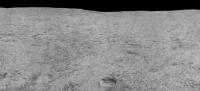
The next installment of the Surveyor 6 pan. This is just above the last one, extending to the horizon.
The pit in the foreground is a footpad imprint from the initial landing. This is from after the 'hop'. Phil
-------------------- ... because the Solar System ain't gonna map itself.
Also to be found posting similar content on https://mastodon.social/@PhilStooke Maps for download (free PDF: https://upload.wikimedia.org/wikipedia/comm...Cartography.pdf NOTE: everything created by me which I post on UMSF is considered to be in the public domain (NOT CC, public domain) |
|
|
|
|
|
|
Mar 22 2006, 08:34 PM
Post
#75
|
||
|
Solar System Cartographer Group: Members Posts: 10231 Joined: 5-April 05 From: Canada Member No.: 227 |
Here's a full resolution section from the Surveyor 6 panorama. The horizon southeast of the spacecraft.
Phil
-------------------- ... because the Solar System ain't gonna map itself.
Also to be found posting similar content on https://mastodon.social/@PhilStooke Maps for download (free PDF: https://upload.wikimedia.org/wikipedia/comm...Cartography.pdf NOTE: everything created by me which I post on UMSF is considered to be in the public domain (NOT CC, public domain) |
|
|
|
|
|
|

|
Lo-Fi Version | Time is now: 28th September 2024 - 11:36 AM |
|
RULES AND GUIDELINES Please read the Forum Rules and Guidelines before posting. IMAGE COPYRIGHT |
OPINIONS AND MODERATION Opinions expressed on UnmannedSpaceflight.com are those of the individual posters and do not necessarily reflect the opinions of UnmannedSpaceflight.com or The Planetary Society. The all-volunteer UnmannedSpaceflight.com moderation team is wholly independent of The Planetary Society. The Planetary Society has no influence over decisions made by the UnmannedSpaceflight.com moderators. |
SUPPORT THE FORUM Unmannedspaceflight.com is funded by the Planetary Society. Please consider supporting our work and many other projects by donating to the Society or becoming a member. |
|