Apollo Sites from LRO |

  |
Apollo Sites from LRO |
 Jul 18 2009, 02:14 AM Jul 18 2009, 02:14 AM
Post
#61
|
||
 Junior Member  Group: Members Posts: 55 Joined: 1-May 06 From: Cincinnati, Ohio Member No.: 758 |
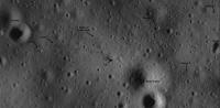
This one is a vertical view from the Eagle during rendezvous. Note the CM below and the "estimated" landing point.
Attached thumbnail(s)
|
|
 |
 
|
|
|
Jul 18 2009, 08:51 AM
Post
#62
|
|
|
Member Group: Members Posts: 233 Joined: 21-April 05 Member No.: 328 |
Belleraphon1, even before reading your posts re the Apollo 14 landing site, I was pretty sure I saw tracks wandering off to the east/north east. And this is exactly in the direction of Cone Crater! BTW, I am not as up on my Apollo history as I should be, but the edge of Cone Crater is about 1 km from the landing site. That's pretty nervy, walking that distance from the [relative] security of the LEM!
robspace54, i's a very useful diagram you've dug up, of the various camera angles etc. around the Apollo 11 landing site. |
|
|
|
|
Jul 18 2009, 12:41 PM
Post
#63
|
|
 Member Group: Members Posts: 753 Joined: 23-October 04 From: Greensboro, NC USA Member No.: 103 |
QUOTE (jekbradbury @ Jul 17 2009, 08:02 PM)  Another attempt on the A11 image, using GIMP's Destripe filter and two runs of the NEDI upscaling algorithm: Does anyone else see a black dot in the approximate location the flag was? Can't tell if it's a small crater, a processing artifact, or if something is actually casting a shadow. I know that the LMP said the flag blew over - I just think this is an interesting coincidence. -------------------- Jonathan Ward
Manning the LCC at http://www.apollolaunchcontrol.com |
|
|
|
|
Jul 18 2009, 01:26 PM
Post
#64
|
||
|
Junior Member Group: Members Posts: 55 Joined: 1-May 06 From: Cincinnati, Ohio Member No.: 758 |
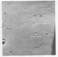
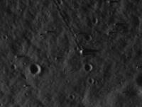
QUOTE (glennwsmith @ Jul 18 2009, 03:51 AM) Belleraphon1, even before reading your posts re the Apollo 14 landing site, I was pretty sure I saw tracks wandering off to the east/north east. And this is exactly in the direction of Cone Crater! BTW, I am not as up on my Apollo history as I should be, but the edge of Cone Crater is about 1 km from the landing site. That's pretty nervy, walking that distance from the [relative] security of the LEM! robspace54, i's a very useful diagram you've dug up, of the various camera angles etc. around the Apollo 11 landing site. As for nervy, think about where they were and what they were doing! I can also see that black dot, but based on the "map" it looks too close to the descent stage. BUT... if you look almost due south about 3 "LMs" away the EASEP seismometer is visible. It is a rectangular looking blob, long axis north-south, with a shadow to the east. I also "see" the LRRR just meters north of the seismometer. Rob
Attached thumbnail(s)
|
|
|
|
|
|
|
Jul 18 2009, 01:52 PM
Post
#65
|
||
|
Junior Member Group: Members Posts: 55 Joined: 1-May 06 From: Cincinnati, Ohio Member No.: 758 |
ADMIN EDIT
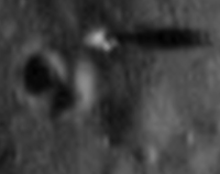
Looks like Pierre Mion got it right! Rob
Attached thumbnail(s)
|
|
|
|
|
|
|
Jul 18 2009, 04:30 PM
Post
#66
|
||
|
Member Group: Members Posts: 104 Joined: 1-June 08 Member No.: 4172 |
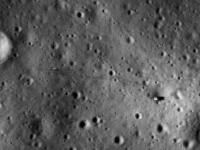
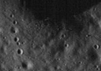
Here's the Apollo 14 landing site, with the same processing:
|
|
|
|
|
|
|
Jul 18 2009, 04:40 PM
Post
#67
|
|
|
Member Group: Members Posts: 753 Joined: 23-October 04 From: Greensboro, NC USA Member No.: 103 |
This processing technique "doubles" some of the small craters, does it? I assume it's due to the compression? Or is it just my imagination too? Both this and the A11 site look like they have rabbit or deer prints across them.
-------------------- Jonathan Ward
Manning the LCC at http://www.apollolaunchcontrol.com |
|
|
|
|
Jul 18 2009, 04:41 PM
Post
#68
|
||
|
Solar System Cartographer Group: Members Posts: 10231 Joined: 5-April 05 From: Canada Member No.: 227 |
A bit more on Apollo 14:
The tracks from Station A to Station B are very clear, even the little loop they did at Station B around a little crater. Tracks from LM to A are visible too. I can't see the return tracks from Station G around North Triplet at all. (no crater doubling here - it's all in how you deal with the stripes!) Phil -------------------- ... because the Solar System ain't gonna map itself.
Also to be found posting similar content on https://mastodon.social/@PhilStooke Maps for download (free PDF: https://upload.wikimedia.org/wikipedia/comm...Cartography.pdf NOTE: everything created by me which I post on UMSF is considered to be in the public domain (NOT CC, public domain) |
|
|
|
|
|
|
Jul 18 2009, 04:52 PM
Post
#69
|
|
|
Member Group: Members Posts: 813 Joined: 29-December 05 From: NE Oh, USA Member No.: 627 |
QUOTE (robspace54 @ Jul 18 2009, 08:26 AM) As for nervy, think about where they were and what they were doing! I can also see that black dot, but based on the "map" it looks too close to the descent stage. BUT... if you look almost due south about 3 "LMs" away the EASEP seismometer is visible. It is a rectangular looking blob, long axis north-south, with a shadow to the east. I also "see" the LRRR just meters north of the seismometer. Rob glennwsmith and robspace54.... yeah that is why Apollo 14 is one of my favorite missions. They were really extending their EVA reach, given no Rover. Any yeah, I am pretty confidant now those are the tracks going NE. They follow the mission plot pretty well. Cannot wait to see Cone Crater. Listen to the transcipts here http://history.nasa.gov/alsj/a14/a14.html |
|
|
|
|
Jul 18 2009, 05:25 PM
Post
#70
|
|
 Member Group: Members Posts: 150 Joined: 3-June 08 From: McLean, VA Member No.: 4177 |
QUOTE (Phil Stooke) The tracks from Station A to Station B are very clear, even the little loop they did at Station B around a little crater. Tracks from LM to A are visible too. I can't see the return tracks from Station G around North Triplet at all. Amazing processing! It almost seems dead certain that all of the site images will have clear EVA trails when LRO is done. Rob, you've convinced me about the '11 seismometer. (I've gotta get back to work!) |
|
|
|
|
Jul 18 2009, 06:04 PM
Post
#71
|
|
 Senior Member Group: Members Posts: 1281 Joined: 18-December 04 From: San Diego, CA Member No.: 124 |
Can't wait for Apollo 12 and the images of an actual unmanned spacecraft
 BTW, this thread is phenomenal. I am in awe at how fast board members update the imagery with the dialog- moving at the speed of thought! -------------------- Lyford Rome
"Zis is not nuts, zis is super-nuts!" Mathematician Richard Courant on viewing an Orion test |
|
|
|
|
Jul 18 2009, 08:19 PM
Post
#72
|
||
|
Solar System Cartographer Group: Members Posts: 10231 Joined: 5-April 05 From: Canada Member No.: 227 |
This is Apollo 17 station 6, the big split boulder. If you compare it with my first view of it (page 2 of this thread), this is much better. This is from the raw TIFF file, which is much better to work with than the zoomify version. Thanks, Mark Robinson, for letting us have this so soon.
Phil
PS - there's a fantastic mountaintop south of the valley at this site with a huge cluster of boulders on it. -------------------- ... because the Solar System ain't gonna map itself.
Also to be found posting similar content on https://mastodon.social/@PhilStooke Maps for download (free PDF: https://upload.wikimedia.org/wikipedia/comm...Cartography.pdf NOTE: everything created by me which I post on UMSF is considered to be in the public domain (NOT CC, public domain) |
|
|
|
|
|
|
Jul 18 2009, 09:11 PM
Post
#73
|
||
|
Solar System Cartographer Group: Members Posts: 10231 Joined: 5-April 05 From: Canada Member No.: 227 |
This is Apollo 17 station 5 on the edge of Camelot crater. It's the place where the famous images of an astronaut in a dramatic boulder field were taken. The rocks are visible along the rim, but no tracks I can make out.
Phil
-------------------- ... because the Solar System ain't gonna map itself.
Also to be found posting similar content on https://mastodon.social/@PhilStooke Maps for download (free PDF: https://upload.wikimedia.org/wikipedia/comm...Cartography.pdf NOTE: everything created by me which I post on UMSF is considered to be in the public domain (NOT CC, public domain) |
|
|
|
|
|
|
Jul 18 2009, 09:48 PM
Post
#74
|
|
 The Poet Dude Group: Moderator Posts: 5551 Joined: 15-March 04 From: Kendal, Cumbria, UK Member No.: 60 |
QUOTE (Phil Stooke @ Jul 18 2009, 10:11 PM) It's the place where the famous images of an astronaut in a dramatic boulder field were taken. This one..? http://www.lpod.org/wp-content/uploads/2007/12/Ap17-pan.jpg -------------------- |
|
|
|
|
Jul 18 2009, 09:56 PM
Post
#75
|
|
|
Solar System Cartographer Group: Members Posts: 10231 Joined: 5-April 05 From: Canada Member No.: 227 |
Yes, that one. Pretty nice, huh?
Phil -------------------- ... because the Solar System ain't gonna map itself.
Also to be found posting similar content on https://mastodon.social/@PhilStooke Maps for download (free PDF: https://upload.wikimedia.org/wikipedia/comm...Cartography.pdf NOTE: everything created by me which I post on UMSF is considered to be in the public domain (NOT CC, public domain) |
|
|
|
|

|
Lo-Fi Version | Time is now: 28th September 2024 - 06:18 PM |
|
RULES AND GUIDELINES Please read the Forum Rules and Guidelines before posting. IMAGE COPYRIGHT |
OPINIONS AND MODERATION Opinions expressed on UnmannedSpaceflight.com are those of the individual posters and do not necessarily reflect the opinions of UnmannedSpaceflight.com or The Planetary Society. The all-volunteer UnmannedSpaceflight.com moderation team is wholly independent of The Planetary Society. The Planetary Society has no influence over decisions made by the UnmannedSpaceflight.com moderators. |
SUPPORT THE FORUM Unmannedspaceflight.com is funded by the Planetary Society. Please consider supporting our work and many other projects by donating to the Society or becoming a member. |
|