My personnal MER 3d software |

  |
My personnal MER 3d software |
 May 18 2006, 07:56 AM May 18 2006, 07:56 AM
Post
#46
|
||
 Member  Group: Members Posts: 239 Joined: 20-April 05 From: Bruxelles, Belgium Member No.: 278 |
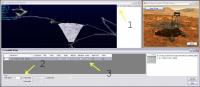
QUOTE (djellison @ May 18 2006, 08:32 AM)  What would be good is to be able to present the mobility traces without any wedges at all - I know it might seem odd, but I'd like it  Doug but you can do 
you can show/hide wedges with check boxe 1 et 3 ( view screenshot in attach ) and with zone 2 you can change offset loaded path example : you load wedge in site "60" with path offset 2 ( by default ), path of site ("58","59","60","61","62" ) are loaded, put "200" or upper, and all path are loaded ... I do not know if I am very clear, but with this, you can view all opportunity or spirit path in 3D without wedge ... i have in may plan to add a label on path for more for more clearness. -------------------- |
|
 |
 
|
|
|
May 18 2006, 08:03 AM
Post
#47
|
|
|
Founder Group: Chairman Posts: 14434 Joined: 8-February 04 Member No.: 1 |
Ahh - so Path offset is the number of site's of mobility data that are shown before and after the site or sites you've added! I was trying to think of a word to describe it - but I can't
One thing - have you tried some of the XYL's and RSL's from Sol 1? The ones that are only 256 x 256....it just crashes when attempting to add the file for me. Doug |
|
|
|
|
May 18 2006, 08:21 AM
Post
#48
|
|
|
Member Group: Members Posts: 239 Joined: 20-April 05 From: Bruxelles, Belgium Member No.: 278 |
QUOTE (djellison @ May 18 2006, 10:03 AM) Ahh - so Path offset is the number of site's of mobility data that are shown before and after the site or sites you've added! I was trying to think of a word to describe it - but I can't One thing - have you tried some of the XYL's and RSL's from Sol 1? The ones that are only 256 x 256....it just crashes when attempting to add the file for me. Doug have you the filename of XYL who causes the crash ? -------------------- |
|
|
|
|
May 18 2006, 08:32 AM
Post
#49
|
|
|
Senior Member Group: Moderator Posts: 4279 Joined: 19-April 05 From: .br at .es Member No.: 253 |
QUOTE (CosmicRocker @ May 18 2006, 05:38 AM) As proof, here is a screen shot from an Opportunity site. [attachment=5671:attachment] Mmm, site 62TO? Navcams taken mid-drive on sol 617 just approaching what we called the "Four Lane". |
|
|
|
|
May 18 2006, 02:39 PM
Post
#50
|
|
 Senior Member Group: Members Posts: 2228 Joined: 1-December 04 From: Marble Falls, Texas, USA Member No.: 116 |
Tesheiner: I don't remember the site ID, but it was from sol 617. The fact that you recognized it in that unlabeled image simply blows my mind.

-------------------- ...Tom
I'm not a Space Fan, I'm a Space Exploration Enthusiast. |
|
|
|
|
May 18 2006, 03:02 PM
Post
#51
|
|
|
Senior Member Group: Moderator Posts: 4279 Joined: 19-April 05 From: .br at .es Member No.: 253 |
Don't call it unlabelled image; the rover's path was superimposed on the picture and the left part of it reminded me of the "northwest detour" (sols 619-631), so the actual site would have to be nearby.
|
|
|
|
|
May 18 2006, 07:29 PM
Post
#52
|
||||
|
Member Group: Members Posts: 239 Joined: 20-April 05 From: Bruxelles, Belgium Member No.: 278 |
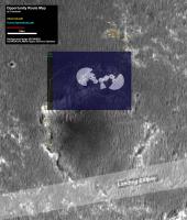
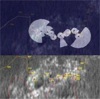
My first attempt to match satelite and ground view
opportunity on site 62 ( sol 582 - 617 ) Generated with my software and XYL/RSL data
superimposed on satellite view
and references marks
and video ( but it's not very good by this way )  http://www.youtube.com/watch?v=nov3QSYsH5c -------------------- |
|||
|
|
|
|||
|
May 18 2006, 07:43 PM
Post
#53
|
|
|
Solar System Cartographer Group: Members Posts: 10231 Joined: 5-April 05 From: Canada Member No.: 227 |
Amazing stuff. Thanks for this great contribution!
Phil -------------------- ... because the Solar System ain't gonna map itself.
Also to be found posting similar content on https://mastodon.social/@PhilStooke Maps for download (free PDF: https://upload.wikimedia.org/wikipedia/comm...Cartography.pdf NOTE: everything created by me which I post on UMSF is considered to be in the public domain (NOT CC, public domain) |
|
|
|
|
May 18 2006, 07:46 PM
Post
#54
|
|
|
Founder Group: Chairman Posts: 14434 Joined: 8-February 04 Member No.: 1 |
Utterly brilliant stuff.
I scrolled my way around the mobility data for all of Opportunity (I still don't understand how they got back from Pan Pos 2 to Karatepe before going in ) - and actually, it's not too bad, a few 'burps' in the dataNot sure if it would be any use, but there is new data from OSU that puts each site and drive into an accurate global frame... http://anserver1.eprsl.wustl.edu/anteam/merb/merb.htm I'm off to bribe my ISP so I can download thousands of XYLs Doug |
|
|
|
|
May 18 2006, 07:51 PM
Post
#55
|
|
 Senior Member Group: Members Posts: 2492 Joined: 15-January 05 From: center Italy Member No.: 150 |
Indian, this strongly recall the work I did with Pov-Ray re-projected images during approach to Erebus!
 Obviously, your work is more rigorous both in terms of path/coordinates both in terms of DEM (I worked with flat terrain!). I suggest you to increase the contrast of the projected terrain in order to better distinguish/compare these features. What about more recent data? (I guess official coordinates and DEMs aren't yet available, correct?) -------------------- I always think before posting! - Marco -
|
|
|
|
|
May 19 2006, 01:44 AM
Post
#56
|
||
|
Member Group: Members Posts: 204 Joined: 29-June 05 Member No.: 421 |
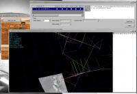
Partial success: by copying the ICSharpCode dll from the earlier zip file I get the R3 version to run and display something of images. But the whole wedges won't show at once; in fact only columns of pixels which are partly in the window and partly offscreen seem to show. Odd.
|
|
|
|
|
|
|
May 19 2006, 04:30 AM
Post
#57
|
||
|
Member Group: Members Posts: 239 Joined: 20-April 05 From: Bruxelles, Belgium Member No.: 278 |
QUOTE (tfisher @ May 19 2006, 03:44 AM) Partial success: by copying the ICSharpCode dll from the earlier zip file I get the R3 version to run and display something of images. But the whole wedges won't show at once; in fact only columns of pixels which are partly in the window and partly offscreen seem to show. Odd.
and with R2 you have the same probleme. try with more xyl ... -------------------- |
|
|
|
|
|
|
May 19 2006, 06:06 AM
Post
#58
|
|
|
Member Group: Members Posts: 239 Joined: 20-April 05 From: Bruxelles, Belgium Member No.: 278 |
QUOTE (djellison @ May 18 2006, 09:46 PM) Not sure if it would be any use, but there is new data from OSU that puts each site and drive into an accurate global frame... Doug yes I am entraint to look at if both are in phase -------------------- |
|
|
|
|
May 19 2006, 06:22 AM
Post
#59
|
|
|
Member Group: Members Posts: 239 Joined: 20-April 05 From: Bruxelles, Belgium Member No.: 278 |
QUOTE (dilo @ May 18 2006, 09:51 PM) Indian, this strongly recall the work I did with Pov-Ray re-projected images during approach to Erebus! Obviously, your work is more rigorous both in terms of path/coordinates both in terms of DEM (I worked with flat terrain!). I suggest you to increase the contrast of the projected terrain in order to better distinguish/compare these features. What about more recent data? (I guess official coordinates and DEMs aren't yet available, correct?) I think that there are only DEM for Eagle and Endurance, but if somebody has the DEM for Columbia Hill, I am very interest i can take some screenshoot with a better resolution, if you want ... -------------------- |
|
|
|
|
May 19 2006, 07:05 AM
Post
#60
|
|
|
Founder Group: Chairman Posts: 14434 Joined: 8-February 04 Member No.: 1 |
|
|
|
|
|

|
Lo-Fi Version | Time is now: 28th September 2024 - 11:36 AM |
|
RULES AND GUIDELINES Please read the Forum Rules and Guidelines before posting. IMAGE COPYRIGHT |
OPINIONS AND MODERATION Opinions expressed on UnmannedSpaceflight.com are those of the individual posters and do not necessarily reflect the opinions of UnmannedSpaceflight.com or The Planetary Society. The all-volunteer UnmannedSpaceflight.com moderation team is wholly independent of The Planetary Society. The Planetary Society has no influence over decisions made by the UnmannedSpaceflight.com moderators. |
SUPPORT THE FORUM Unmannedspaceflight.com is funded by the Planetary Society. Please consider supporting our work and many other projects by donating to the Society or becoming a member. |
|