The West Valley Route |

  |
The West Valley Route |
 Mar 27 2009, 01:11 AM Mar 27 2009, 01:11 AM
Post
#91
|
|
 Senior Member  Group: Members Posts: 1619 Joined: 12-February 06 From: Bergerac - FR Member No.: 678 |
Hé hé hé Climber
 My version of the West Valley route in color of the Sol 1851  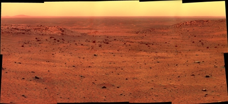
-------------------- |
 |
 
|
|
Mar 27 2009, 05:42 AM
Post
#92
|
|
|
Member Group: Admin Posts: 976 Joined: 29-September 06 From: Pasadena, CA - USA Member No.: 1200 |
QUOTE (climber @ Mar 26 2009, 01:03 PM)  IIRC, one of the reason for not using the West Valley Route was because we didn't have enough visual informations as compared to crossing HP or using the East route. Not mentioning the laters were shorter, etc... Once again, looking at Eduardo's map, I'd said that I guess we have very good coverage (even from to of HP) around Gibson then again around Tartarus; this leads to sol 1363 drive that will join sol 1350 way point. Either I missunderstood or this is not enough to call the route "known enough" for a Rover Driver standard. Anyway, even if we can use the pictures we have down to sol 1350 way point or so, this will cover half the distance to Von Braun.  Of all the routes to VB/G the west valley route was the one that had most coverage which indicated some narrow passages (meaning good driving terrain in some areas might be narrow). Aerial imagery seem to indicate that the terrain N and NW of VB can be difficult to traverse. Unfortunately there is no way to get surface imaging before the rover actually gets there. ;-) And then you know that rover drivers don't ever have enough data about traversability. Not even after driving on it. ;-) Paolo -------------------- Disclaimer: all opinions, ideas and information included here are my own,and should not be intended to represent opinion or policy of my employer.
|
|
|
|
|
Mar 28 2009, 08:09 PM
Post
#93
|
||
|
Senior Member Group: Members Posts: 2922 Joined: 14-February 06 From: Very close to the Pyrénées Mountains (France) Member No.: 682 |
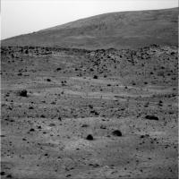
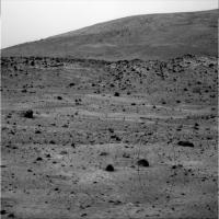
I think I've found sol 743 weels tracks
Visible for a few meters before and after these two black rocks in the first 1/4 from the back of the picture a little bit on the right from the center. Agree?
-------------------- |
|
|
|
|
|
|
Mar 28 2009, 09:30 PM
Post
#94
|
||
|
Senior Member Group: Moderator Posts: 4279 Joined: 19-April 05 From: .br at .es Member No.: 253 |
Good catch, climber!
Really, really difficult to see but they are actually there.
http://qt.exploratorium.edu/mars/spirit/pa...LTP2355R2M1.JPG |
|
|
|
|
|
|
Mar 28 2009, 10:09 PM
Post
#95
|
|
 Senior Member Group: Members Posts: 1887 Joined: 20-November 04 From: Iowa Member No.: 110 |
QUOTE (jamescanvin @ Mar 26 2009, 10:26 AM) Might also be a good time to repost the full Gibson Pan: Posted 26/02/2006 - 37 months ago. Back when Spirit was young a sprightly and able to climb HP here. And the colour anaglyph James, did you do a color 3D version of the West Valley Pan, sols 1366-1369? |
|
|
|
|
Mar 29 2009, 10:02 AM
Post
#96
|
|
|
Senior Member Group: Moderator Posts: 4279 Joined: 19-April 05 From: .br at .es Member No.: 253 |
Today was driving sol and I just checked the pancam web to find out that Spirit did another 20+ meters move, definitely entering the West Valley.
Looking forward the pictures to confirm it. Meanwhile, I'll make a preliminary route map update... Done. |
|
|
|
|
Mar 29 2009, 02:02 PM
Post
#97
|
|
|
Member Group: Members Posts: 915 Joined: 4-September 06 From: Boston Member No.: 1102 |
The Images are down and look at this White Trench.
[Temp residence: Old Swan Hotel, Harrogate, North Yorkshire] -------------------- |
|
|
|
|
Mar 29 2009, 03:31 PM
Post
#98
|
|
 Senior Member Group: Members Posts: 4252 Joined: 17-January 05 Member No.: 152 |
QUOTE (climber @ Mar 28 2009, 09:09 PM) I think I've found sol 743 weels tracks Nice job spotting the tracks, climber! I think what helps their visibility here is that we're looking straight "up" the tracks, so they are heavily foreshortened, so a long stretch of tracks is compressed into a short span of the image. The exposed white stuff shows nicely again how we completely missed this material during our previous pass through here in the mid sol 700's with six good wheels. Given their interest in the white stuff we exposed on the north side of HP, I wonder if we'll be pausing for a bit to take a closer look here? |
|
|
|
|
Mar 29 2009, 04:03 PM
Post
#99
|
|
|
Junior Member Group: Members Posts: 90 Joined: 23-February 09 From: Edmonton, Alberta Member No.: 4611 |
" look at this White Trench. "
that's an amazing shot... what is that... 15-20 meters. wow Given how valuable the broken wheel has turned out to be wonder if the MSL team has decided to add another piece of equipment ... the DATT (Drive Actuated Trenching Tool) (actually I'm serious.. a stick that drags while driving would seem to be a really good idea) |
|
|
|
|
Mar 29 2009, 04:13 PM
Post
#100
|
|
 Member Group: Members Posts: 276 Joined: 11-December 07 From: Dar es Salaam, Tanzania Member No.: 3978 |
It seems the distribution of the white material is more widespread than originally thought (maybe it surrounds all of HP). It would be interesting to see if Goddard is also surrounded by the material if indeed it is a volcanic feature.
-------------------- |
|
|
|
|
Mar 29 2009, 07:59 PM
Post
#101
|
|
|
Solar System Cartographer Group: Members Posts: 10197 Joined: 5-April 05 From: Canada Member No.: 227 |
I'm responding to Alan's route map, but like a good UMSFer I'm posting it here to keep chat out of the map thread.
Alan, your map is especially useful, I think, for its view of the slopes ahead of us. It looks as if a drive on the WEST side of von Braun would drop the rover too much, so it might have trouble coming back up on the south side (not to mention, the south side would be bad for sun until deep summer). The best route might be to get around Home Plate and then try to get into the valley between VB and Goddard. I've always thought that the stratigraphy at the SW corner of Home Plate might be the most complete section - it appears to be the highest part of the edge. If it's not too blanketed with debris we might see layering better there than at the NW corner. Of course, we need the overhead map as well... an oblique view like this loses too many places behind the topography. EDIT: fredk (next post) was of course right - WEST side of VB. I corrected it above. I was looking in the wrong direction... duh... Phil -------------------- ... because the Solar System ain't gonna map itself.
Also to be found posting similar content on https://mastodon.social/@PhilStooke Maps for download (free PD: https://upload.wikimedia.org/wikipedia/comm...Cartography.pdf NOTE: everything created by me which I post on UMSF is considered to be in the public domain (NOT CC, public domain) |
|
|
|
|
Mar 29 2009, 09:08 PM
Post
#102
|
|
|
Senior Member Group: Members Posts: 4252 Joined: 17-January 05 Member No.: 152 |
QUOTE (Phil Stooke @ Mar 29 2009, 08:59 PM) It looks as if a drive on the east side of von Braun would drop the rover too much Just to be clear, I assume you mean a drive on the west side would drop the rover too much. It sounds like a good strategy. Basically, since we can presumably always travel downslope, it makes sense to keep as high as you can for as long as you can (as Tesheiner mentioned regarding the drive through West Valley). That way we always can head downslope once we're done with the higher regions. I don't recall hearing it at the time, but this would've been another advantage of the "over HP" route - we would've ended up quite high. Of course that route turned out to be not doable. |
|
|
|
| Guest_Oersted_* |
Mar 29 2009, 09:34 PM
Post
#103
|
|
Guests |
QUOTE (JayB @ Mar 29 2009, 06:03 PM) (actually I'm serious.. a stick that drags while driving would seem to be a really good idea) They will be able to just put the brakes on one wheel I hope, and will use MSL trenching, I hope, if, sorry, WHEN she lands safely on Mars. That is indeed an amazing white trench Spirit just dug there. I guess it will be visible with HiRise! Hope they'll sniff it. |
|
|
|
|
Mar 29 2009, 10:42 PM
Post
#104
|
|
 Senior Member Group: Moderator Posts: 3431 Joined: 11-August 04 From: USA Member No.: 98 |
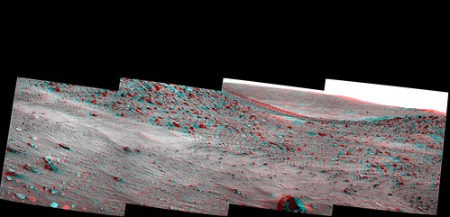 Pancam anaglyph view south, Spirit sol 1861 |
|
|
|
|
Mar 29 2009, 11:14 PM
Post
#105
|
|
 Senior Member Group: Admin Posts: 3108 Joined: 21-December 05 From: Canberra, Australia Member No.: 615 |
In the anaglyph it looks like that on either side of the potential drive path there are some small hollows.
Tartarus Warning!!!!  Maybe not, but this is going to present some interesting times for the MER Precision Driving Team. Maybe not, but this is going to present some interesting times for the MER Precision Driving Team.
|
|
|
|
|

|
Lo-Fi Version | Time is now: 27th June 2024 - 05:02 PM |
|
RULES AND GUIDELINES Please read the Forum Rules and Guidelines before posting. IMAGE COPYRIGHT |
OPINIONS AND MODERATION Opinions expressed on UnmannedSpaceflight.com are those of the individual posters and do not necessarily reflect the opinions of UnmannedSpaceflight.com or The Planetary Society. The all-volunteer UnmannedSpaceflight.com moderation team is wholly independent of The Planetary Society. The Planetary Society has no influence over decisions made by the UnmannedSpaceflight.com moderators. |
SUPPORT THE FORUM Unmannedspaceflight.com is funded by the Planetary Society. Please consider supporting our work and many other projects by donating to the Society or becoming a member. |
|