China to the Moon - Chang'e 1 and 2, Chinese unmanned lunar orbiters |

  |
China to the Moon - Chang'e 1 and 2, Chinese unmanned lunar orbiters |
 Nov 23 2007, 03:00 PM Nov 23 2007, 03:00 PM
Post
#46
|
|
|
Senior Member  Group: Members Posts: 1074 Joined: 21-September 07 From: Québec, Canada Member No.: 3908 |
China to publish first picture of the Moon in 3 days.
http://news.xinhuanet.com/english/2007-11/...ent_7133451.htm |
 |
 
|
|
Nov 26 2007, 03:04 AM
Post
#47
|
|
|
Solar System Cartographer Group: Members Posts: 10197 Joined: 5-April 05 From: Canada Member No.: 227 |
-------------------- ... because the Solar System ain't gonna map itself.
Also to be found posting similar content on https://mastodon.social/@PhilStooke Maps for download (free PD: https://upload.wikimedia.org/wikipedia/comm...Cartography.pdf NOTE: everything created by me which I post on UMSF is considered to be in the public domain (NOT CC, public domain) |
|
|
|
|
Nov 26 2007, 09:59 AM
Post
#48
|
|
|
Senior Member Group: Members Posts: 3516 Joined: 4-November 05 From: North Wales Member No.: 542 |
I'm having no luck getting that picture. Anybody else managed it?
|
|
|
|
|
Nov 26 2007, 10:17 AM
Post
#49
|
|
|
Founder Group: Chairman Posts: 14433 Joined: 8-February 04 Member No.: 1 |
The direct link ( http://www.cnsa.gov.cn/n615709/n620682/n63...ges/1798638.jpg ) is slightly more reliable - but still exceptionally slow - first one to get it in full, attach it to a post here
Doug |
|
|
|
|
Nov 26 2007, 10:55 AM
Post
#50
|
||
|
Merciless Robot Group: Admin Posts: 8784 Joined: 8-December 05 From: Los Angeles Member No.: 602 |
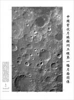
Got it. Now if I could only read the caption...

Attached thumbnail(s)
-------------------- A few will take this knowledge and use this power of a dream realized as a force for change, an impetus for further discovery to make less ancient dreams real.
|
|
|
|
|
|
|
Nov 26 2007, 01:51 PM
Post
#51
|
|
|
Solar System Cartographer Group: Members Posts: 10197 Joined: 5-April 05 From: Canada Member No.: 227 |
From http://news.xinhuanet.com/english/2007-11/...ent_7145873.htm
" The area covered by the picture, about 460 kilometers in length and 280 km in width, was located within a 54 to 70 degrees south latitude and 57 to 83 degrees east longitude, according to the BACC. The area pictured was part of the moon's highland and was mainly composed of plagioclase, a common rock-forming element. On the surface were craters of different sizes, shapes, structures and ages, the BACC sources said. "The dark patch in the picture's upper right side shows the surface blanketed by basalt, a hard and dense volcanic rock," the sources said. Sun Laiyan, chief of the China National Space Administration, said the picture was very clear and of very good quality. "It shows that the camera and the ground control and application systems are all working normally," said Sun at a press conference on Monday afternoon. The picture was pieced together by 19 images, each covering a width of 60 kilometers on the moon's surface. The far right of the picture was the first area to be captured by the CCD camera aboardChang'e-1. All the image data was collected on Nov. 20 and Nov. 21 and processed into a three-dimensional picture in several days after being transmitted back to Earth. " Phil -------------------- ... because the Solar System ain't gonna map itself.
Also to be found posting similar content on https://mastodon.social/@PhilStooke Maps for download (free PD: https://upload.wikimedia.org/wikipedia/comm...Cartography.pdf NOTE: everything created by me which I post on UMSF is considered to be in the public domain (NOT CC, public domain) |
|
|
|
|
Nov 27 2007, 04:07 PM
Post
#52
|
|
|
Junior Member Group: Members Posts: 86 Joined: 12-October 05 From: Beijing Member No.: 526 |
QUOTE (nprev @ Nov 26 2007, 06:55 PM)  Got it. Now if I could only read the caption... The text on the right reads "中国首次月球探测工程第一幅月面图像" (Literally: China's first-time lunar exploration project first lunar surface picture) The text on the bottom-left is too small, but some characters are still readable, google search the characters that readable reveal the full text: "中国首次月球探测工程第一幅月面图像是由嫦娥一号卫星上的CCD立体相机获得的。CCD相机采用线阵推扫的方式获取图像,轨道高度约200km,每一轨的月面幅宽60km,像元分辨率120m。中国第一幅月面图像共由19轨图像制作而成,位于月表东经83度到东经57度,南纬70度到南纬54度,图幅宽约280km,长约460km。图中右侧60公里宽的条带,是CCD相机开机获得的第一轨图像。" (Translation: China's first-time lunar exploration project first lunar surface picture was captured by the CCD stereo camera of the Chang'e 1 satellite. CCD camera uses the method "xiàn zhèn tuī sǎo" (literally: "linear, matrix, push, scan", not sure how to translate :-( ) to capture images, the orbit altitude was about 200 km, each orbit lunar surface width was 60 km, per pixel resolution was 120 m. China's first lunar surface picture was made up from 19-orbit's image, located at longitude 83 to 57 degrees east, latitude 70 to 54 degrees south, the mosaic image's width is 280 km, height is 460 km. The 60 km wide square-shape bar on the right of the picture was the first image that captured after the CCD was turned on.) |
|
|
|
|
Nov 27 2007, 04:14 PM
Post
#53
|
|
|
Junior Member Group: Members Posts: 86 Joined: 12-October 05 From: Beijing Member No.: 526 |
This is a comparison between Chang'e 1's image and Google Moon:
http://bbs1.people.com.cn/postDetail.do?id...5&boardId=1 Here is a bigger version of the image: http://news.sina.com.cn/pc/2007-11-26/326/419.html |
|
|
|
|
Nov 27 2007, 04:40 PM
Post
#54
|
|
|
Founder Group: Chairman Posts: 14433 Joined: 8-February 04 Member No.: 1 |
QUOTE (yaohua2000 @ Nov 27 2007, 04:07 PM) (literally: "linear, matrix, push, scan", not sure how to translate :-( ) I assume they mean Pushbroom like MOC, HRSC, HiRIS etc. Doug |
|
|
|
|
Nov 27 2007, 06:35 PM
Post
#55
|
|
 Administrator Group: Admin Posts: 5172 Joined: 4-August 05 From: Pasadena, CA, USA, Earth Member No.: 454 |
yaohua2000, thank you so much for the link to the full-resolution image and the translation of the text!
Here's a question: the full-resolution image is a color JPEG. Is the image actually a color image or a grayscale one? I'm pretty sure it's grayscale, but thought I'd check with wiser image processors...comparing the channels, there seems to be no more than 3-4 DN variation between them, but I know that the Moon is a gray place and am wondering if such small variations in DN could be an artifact of the JPEG compression. --Emily -------------------- My website - My Patreon - @elakdawalla on Twitter - Please support unmannedspaceflight.com by donating here.
|
|
|
|
| Guest_PhilCo126_* |
Nov 27 2007, 06:38 PM
Post
#56
|
|
Guests |
Does that photo show the Biela crater and surroundings?
|
|
|
|
|
Nov 27 2007, 06:45 PM
Post
#57
|
|
|
Administrator Group: Admin Posts: 5172 Joined: 4-August 05 From: Pasadena, CA, USA, Earth Member No.: 454 |
I'm just tracking that down now. With comparisons to the Lunar Orbiter atlas, I find:
The 66-kilometer-diameter crater Gill is just to the lower right of center in this image. Cut off at the upper left side is 91-kilometer Pontecoulant. At the bottom edge is 94-kilometer Helmholtz. See http://www.lpi.usra.edu/resources/lunar_or...n/info.shtml?86 and http://www.lpi.usra.edu/resources/lunar_or.../info.shtml?524 --Emily -------------------- My website - My Patreon - @elakdawalla on Twitter - Please support unmannedspaceflight.com by donating here.
|
|
|
|
|
Nov 27 2007, 09:24 PM
Post
#58
|
|
 Interplanetary Dumpster Diver Group: Admin Posts: 4404 Joined: 17-February 04 From: Powell, TN Member No.: 33 |
I am not sure, but I think it is colorized. However, it also may be a color image balanced around an arbitrary neutral point and with most variation in color beyond the limits of discernment. The color variations don't seem to recognize the dark mare material boundaries (or any morphological features), which leads me to say it is colorized. However, it could be that it is truly a color image of a relatively colorless scene, in which case the variations are due to instrument noise.
-------------------- |
|
|
|
|
Dec 3 2007, 03:05 PM
Post
#59
|
|
|
Senior Member Group: Members Posts: 1074 Joined: 21-September 07 From: Québec, Canada Member No.: 3908 |
Here's an interesting piece of news from Xinhua (http://news.xinhuanet.com/english/2007-12/02/content_7187500.htm)
Data from Chinese lunar orbiter available to all SHANGHAI, Dec. 2 (Xinhua) -- Scientists and astronomy enthusiasts all over the country all have access to data sent back from China's first lunar orbiter Chang'e-I, a leading scientist in the program said here Sunday. Ouyang Ziyuan, academician of the Chinese Academy of Sciences (CAS) and chief scientist of the lunar exploration program, said at present the scientific instruments on board Chang'e-1 have all gone into operation and the satellite is sending back 3 trillion of data per second. The total data volume will reach 28 T (1 T is equivalent to 1,000 G) next year. "The money used for the Chang'e project comes from the taxpayers and, therefore, the data should also be made public. Any scientist or astronomy lover can apply to the state in accordance with certain procedures to obtain data he needs," Ouyang said. It seems that you need to be a Chinese citizen to have access to the data. The article doesn't mention what are the "certain procedures" to follow in order to obtain the data. Any Chinese UMSF member care to look into this? |
|
|
|
|
Dec 3 2007, 05:05 PM
Post
#60
|
|
 Member Group: Members Posts: 124 Joined: 23-March 06 Member No.: 723 |
QUOTE (Toma B @ Oct 24 2007, 09:52 AM) Latest News: I see that a lot of news agencies today seem to be running with the story that China's lunar photo is a fake. The news report is based on internet rumors which say its a copy of a photo taken in 2005 by NASA |
|
|
|
|

|
Lo-Fi Version | Time is now: 26th June 2024 - 10:03 PM |
|
RULES AND GUIDELINES Please read the Forum Rules and Guidelines before posting. IMAGE COPYRIGHT |
OPINIONS AND MODERATION Opinions expressed on UnmannedSpaceflight.com are those of the individual posters and do not necessarily reflect the opinions of UnmannedSpaceflight.com or The Planetary Society. The all-volunteer UnmannedSpaceflight.com moderation team is wholly independent of The Planetary Society. The Planetary Society has no influence over decisions made by the UnmannedSpaceflight.com moderators. |
SUPPORT THE FORUM Unmannedspaceflight.com is funded by the Planetary Society. Please consider supporting our work and many other projects by donating to the Society or becoming a member. |
|